Fact Sheet 2006–3098
Upper Midwest Environmental Sciences Center, La Crosse, Wisconsin
Your doctor would not base decisions for your health care today on one physical examination when you were age three! You would reasonably expect decisions to be based on records from over your lifetime. Likewise, those responsible for monitoring the health of the Upper Mississippi River System want a more comprehensive way to diagnose problems and find treatment options. To begin developing a comprehensive view of the river, the five neighboring states of the Upper Mississippi River System and several Federal agencies formed a partnership in 1986 to monitor river conditions and long-term trends in the Upper Mississippi and Illinois Rivers.
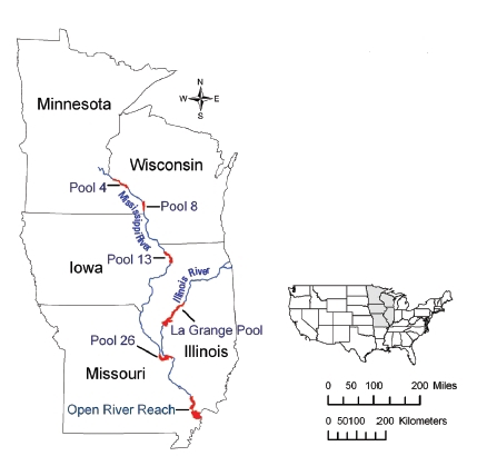
| Monitoring sites: Researchers chose six areas to represent conditions and habitats on the Upper Mississippi River System. |
Six monitoring targets
The overall health of a river is reflected in the health of its biota, such as (1) fish, (2) invertebrates (e.g., insects, worms, and clams), and (3) aquatic plants. The biota are affected by (4) water quality and (5) sedimentation, which are often influenced by surrounding (6) land use and land cover. All are linked. The Long Term Resource Monitoring Program (LTRMP) for the Upper Mississippi River System is the Nation’s first large‑scale effort to determine the status and trends of these natural components of a large river. The mission of the LTRMP is to provide decision-makers with information to help them balance the multiple uses of the Mississippi River. We all benefit from commercial shipping, flood control, recreation, and other ecological services (e.g., biodiversity, water supply, biogeochemical and hydrological cycling) provided by the river. Our goal is to provide the information managers need to create a healthy large river ecosystem.
Accomplishments
This monitoring program is at the forefront of collecting, sharing, and using scientifically-based information to understand how large rivers function and to improve river management. Other countries have taken notice. China, for example, has asked for help in learning how to monitor its Yangtze River.
A sample of what we've learned
The following pages introduce you to some of the findings from the monitoring program over the past 20 years. For full reports and graphic browsers, go to the LTRMP Web page at http://www.umesc.usgs.gov/ltrmp.html—perhaps the world’s best source of ecological data on large rivers.
Fish - good news and bad
The good news is that almost all fish species collected from the Upper Mississippi River System over the past 100 years still exist in the river today. That is more than a quarter of all freshwater species in North America. The bad news is that exotic species, primarily common carp (Cyprinus carpio), make up about half of all the fish by weight.
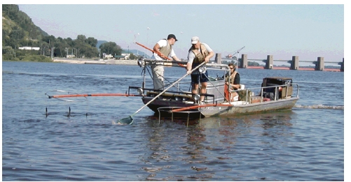
| Researchers annually sample fish (shown here below Lock and Dam 7 at La Crosse, Wisconsin) to help analyze the status of fish populations and detect trends reflecting the overall health of the river. |
Endangered Species: Since 1993, we found 39 rare, endangered, or threatened fish species. This provides state conservation officials with critical information to help recovery efforts for these fishes.
Exotic Species: We are tracking 11 exotic species, including a recent invader, Asian carp (Hypopthalmichthys spp.). The greatest numbers of Asian carp are presently south of Pool 13, but are moving upriver and expanding their range.
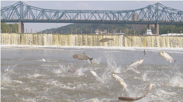
| Silver carp (Hypopthalmichthys molitrix) is only 1 of 11 exotic species researchers are tracking as these fish invade the Upper Mississippi River System. Silver carp are a concern because of their potential detrimental affect on fish habitats and the danger they are to boaters and others on the river when they leap out of the water when the water is disturbed. Photographed below Peoria Lock and Dam, September 2005, by Melissa Smith, Illinois River Biological Station-Illinois Natural History Survey. |
Where the Fish Live: As anglers know, certain fish are found in certain habitats. Where the river has the greatest variety of habitats, including backwaters and side and main channels, is where the greatest variety of fish species will be.The Mississippi River north of the Open River Reach has more backwaters and side channels—and more sport fish—than farther south. We also found that water clarity, current velocity, and aquatic vegetation dictate differences in fish abundance.
Flood Benefits: During the extended flood of 1993 many fish produced more offspring than in a typical year. For some species, however, that does not always lead to more adult fish. Young fish cannot always find the conditions needed to survive to adulthood, especially in southern study reaches (Pool 26, Open River Reach, and La Grange Pool).
Not the Same River: The Illinois River rarely flows as it did historically because of impoundments and changes to its watershed. Today, young native fish are more abundant in years when the water flow is closest to historical conditions. This suggests that returning this river to a more natural state would benefit native fish.

| An abundance of mayflies and fingernail clams is a sign of healthy river habitats. |
Insects, snails, worms, and clams—to name a few—seldom receive publicity, but they are an important food source for almost all animal life in the river.
Water Quality Connection: Mayflies (Hexagenia spp.) and fingernail clams (Sphaeriidae) are important foods for birds and fish. We learned that fewer fingernail clams can live in waters with high suspended sediments. This suggests that management to reduce suspended sediments could increase fingernail clam levels.
One Pool Increase: We detected a slight increase in fingernail clams in Pool 8 from 1993 to 2004 as suspended sediments in the pool decreased. Other areas did not show an increase in the fingernail clams.
Stable Populations: Numbers of mayflies, fingernail clams, and midges measured by our monitoring are similar to numbers reported on the river between 1952 and 1990.
Northern Bounty: The northern study reaches (Pools 4, 8, and 13) have more mayflies, fingernail clams, and midges than do the southern study reaches (Pool 26, Open River Reach, and La Grange Pool).
Submersed aquatic plants serve wild river residents twice. Waterfowl and fish dine on some of the greens. Also, many fish hide their eggs amid the plants, their offspring use plants as shelter to hide from predators, and they feed on invertebrates that live on the plants.
| Submersed aquatic plants, according to our studies, are more abundant in the shallow, protected backwaters in the northern reaches of the Mississippi River. |
Where the Plants Grow: The abundance of submersed aquatic plants in different areas of the Upper Mississippi River System depends mainly on the water clarity, current velocity, and variability of water levels at that location.
Greener North: In general, aquatic plants decrease as one moves southward. Our studies show this is linked to the reduction in shallow, protected areas from north to south along the river.
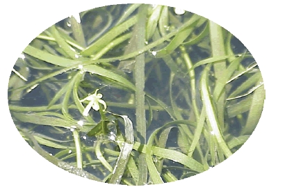
| Water stargrass (Heteranthera dubia) provides food for some waterbirds and homes for aquatic invertebrates consumed by a variety of fish species. |
Rehabilitation Pays Off: After building islands and reducing water levels during summer in Pool 8, we saw a greater growth of aquatic plants in 2001 through 2005. The rehabilitation work created new habitats and improved existing ones where plants could more easily grow and multiply.
Water Quality Connection: Above Lake Pepin (in Pool 4), the abundance of submersed aquatic plants decreased from 1998 to 2001 and has remained low through 2005. We are unsure why, but we suspect the pool’s high amount of suspended sediments is a factor.
Exotic species: We found the exotic aquatic plants Eurasian watermilfoil (Myriophyllum spicatum), curly pondweed (Potamogeton crispus), and brittle water nymph (Najas minor), but they have not yet dominated the native aquatic plants.
Clean water helps fish, invertebrates, and plants, as well as migrating waterfowl to flourish in any river system. But we found that water quality changes substantially from north to south along the Upper Mississippi River System (Pool 4 to Open River Reach).
Decline in Quality: Our studies show that total suspended sediments, turbidity, and concentrations of nitrogen, phosphorous, and chlorophyll are generally much higher in the southern study reaches (Pool 26, Open River Reach, and La Grange Pool).
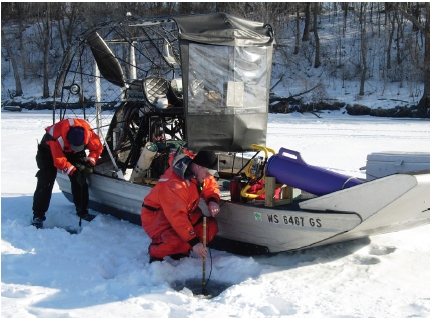
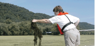
| The Long Term Resource Monitoring Program is year-round work as demonstrated by this crew checking water quality under the ice. |
Inputs off the land: Above Lake Pepin (in Pool 4), suspended sediments and phosphorus concentrations are high due mainly to inputs from the surrounding watershed and the Minnesota River. We found that Lake Pepin acts as a settling basin, greatly reducing these components and sending cleaner waters southward.
Algae Blooms: Summer and fall are periods of relatively low nitrogen and high phosphorus concentrations, conditions favoring growth of nuisance blooms of blue‑green algae.
Channels versus Backwaters: Water quality often differs greatly between the main channel and backwaters. For example, nitrate concentrations are usually higher in the main channel, and algae is often more abundant in backwaters.
Changing with the Seasons: Water quality can vary among years and seasons. For example, main channel nitrate concentrations are often highest in spring, but total concentration varies among wet and dry years due to different flow levels.
Out of Oxygen: Fish cannot live in waters with low dissolved oxygen concentrations. Such low concentrations occur most commonly during summer and winter in backwaters of Pools 4, 8, and 13, and in the main channel of La Grange Pool in summer. We found that low concentrations of dissolved oxygen are rare in other seasons and locations.
Sediment is a natural feature of large rivers, but how it moves has been altered by human activities. Soil erosion from converting prairies and forests to agriculture and urban areas has increased sediment flow in the river. Impoundments such as dams then slow the flow and, often, more silt and sand accumulate than can be moved by the river, causing many problems. Local habitat for plants, invertebrates, and fish may be lost, water quality degraded, and boating endangered.
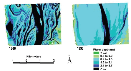
| Elevation data collected before the locks and dams were created can be compared to present day bathymetric (water depth) data to identify areas where sedimentation and erosion have occurred. |
Filling in the Contours: Wind-generated waves sweeping across the open impoundments (lake-like areas on the river) have eroded islands and shallow areas. In deep areas of the impounded waters that have low current velocity, suspended sediment can deposit. The combination of shallower areas getting deeper and deeper areas getting shallower has resulted in more uniform depths in the impounded areas. With less variation in water depth and the loss of islands, fewer kinds of plants and animals can use these areas.
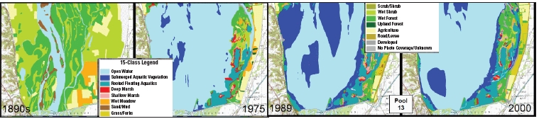
| A century of changes in land cover can be traced with these maps at what is now Pool 13 on the Upper Mississippi River. Before the locks and dams and increased population, forests filled much of the flood plain (left). Now there is more open water, less forest, and more submerged aquatic plants. |
Carrying Silt Southward: From lower Pool 4 through Pool 13, sedimentation increases. We suspect this pattern is due to increasing amounts of suspended sediment being carried downstream, additions from tributary rivers, and differences in backwater size, depth, and shape influencing the way sediment is transported.
Changing Year to Year: In wet years, more water flows faster through the river, carrying more sediment while eroding previous deposits and moving all downriver. In dry years, the river does not have the energy to carry as much sediment. Silt and sand will settle out of the water, accumulating locally.
From north to south, the dominant use and appearance of the Upper Mississippi River System changes considerably.
The upper portion , from the Twin Cities, Minnesota, to Clinton, Iowa (Pools 1–13), is mainly open water (40%) and floodplain forest (21%) with a variety of other habitat types and relatively little agriculture (5%).
In the middle portion , from Clinton, Iowa, to St. Louis, Missouri (Pools 14–26), agriculture becomes more common (48%), while open water (22%) and floodplain forests (17%) decrease.
The lower portion , including the Open River Reach from St. Louis, Missouri, to Cairo, Illinois, and the Illinois River pools, is mainly agricultural (51%) with many levees, extensive channelization, and little variety in habitat. Open water (16%) and floodplain forest (16%) continue to decrease.
Flood Victims in Nature: The large floods in 1993, 1997, and 2001 swept away shallow‑rooted plant species such as arrowhead (Sagittaria), water lily (Nymphaea) and lotus (Nelumbo), and killed trees by drowning their roots. Since 2001, we have found a regrowth of aquatic plants in the northern pools.
Open Water Replaces Marshes: Among habitat types, open water has increased the most in the northern pools since 1989. This change has come at the expense primarily of deep marshes that once contained important plants such as arrowhead, lotus, water lily, and submersed vegetation. Habitat enhancement projects are helping to restore these plants in many sections of the river.
Shrinking Forests: Before European settlement, forests covered much of the floodplain. Now only remnants remain and they continue to shrink. Recent decreases may be due to the 1993 flood and inadequate growth of new trees as the mature trees die. Invasive nonforest species such as reed canary grass are also inhibiting reforestation.
U.S. Geological Survey
Upper Midwest Environmental Sciences Centerkids2enjo
Phone: (608) 783-6451
U.S. Army Corps of Engineers
Phone: (309) 794-5857
U.S. Fish and Wildlife Service
Phone: (612) 713-5178
Illinois Department of Natural Resources
Phone: (217) 785-8264
Iowa Department of Natural Resources
Phone: (515) 281-6976
Minnesota Department of Natural Resources
Phone: (507) 280-5058
Missouri Department of Conservation
Phone: (573) 522-4115
Wisconsin Department of Natural Resources
Phone: (608) 785-9000
U.S. Environmental Protection Agency
Phone: (312) 886-6872
For more information, contact:
Linda Leake or Barry Johnson
U.S. Geological Survey| AccessibilityFOIAPrivacyPolicies and Notices | |
 |
|