Fact Sheet 2006–3125
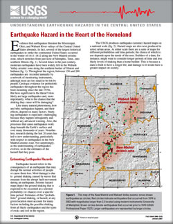
Evidence that earthquakes threaten the Mississippi, Ohio, and Wabash River valleys of the Central United States abounds. In fact, several of the largest historical earthquakes to strike the continental United States occurred in the winter of 1811–1812 along the New Madrid seismic zone, which stretches from just west of Memphis, Tenn., into southern Illinois. Several times in the past century, moderate earthquakes have been widely felt in the Wabash Valley seismic zone along the southern border of Illinois and Indiana. Throughout the region, between 150 and 200 earthquakes are recorded annually by a network of monitoring instruments, although most are too small to be felt by people. Geologic evidence for prehistoric earthquakes throughout the region has been mounting since the late 1970s. But how significant is the threat? How likely are large earthquakes and, more importantly, what is the chance that the shaking they cause will be damaging? |
First posted January 2007 For additional information contact: Part or all of this report is presented in Portable Document Format (PDF); the latest version of Adobe Reader or similar software is required to view it. Download the latest version of Adobe Reader, free of charge. |

![]() U.S. Department of the Interior |
U.S. Geological Survey
U.S. Department of the Interior |
U.S. Geological Survey
URL: http://pubsdata.usgs.gov/pubs/fs/2006/3125/index.html
Page Contact Information: GS Pubs Web Contact
Page Last Modified: Tuesday, 29-Nov-2016 17:24:09 EST
