Fact Sheet 2007-3029
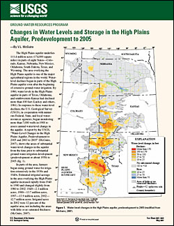
AbstractThe High Plains aquifer underlies 111.4 million acres (174,000 square miles) in parts of eight States-Colorado, Kansas, Nebraska, New Mexico, Oklahoma, South Dakota, Texas, and Wyoming. The area overlying the High Plains aquifer is one of the major agricultural regions in the world. Water-level declines began in parts of the High Plains aquifer soon after the beginning of extensive ground-water irrigation. By 1980, water levels in the High Plains aquifer in parts of Texas, Oklahoma, and southwestern Kansas had declined more than 100 feet (Luckey and others, 1981). In response to these water-level declines, the U.S. Geological Survey (USGS), in cooperation with numerous Federal, State, and local water-resources agencies, began monitoring more than 7,000 wells in 1988 to assess annual water-level change in the aquifer. A report by the USGS, "Water-Level Changes in the High Plains Aquifer, Predevelopment to 2005 and 2003 to 2005" (McGuire, 2007), shows the areas of substantial water-level changes in the aquifer from the time prior to substantial ground-water irrigation development (predevelopment or about 1950) to 2005 (fig. 1). In parts of the area, farmers began using ground water for irrigation extensively in the 1930s and 1940s. Estimated irrigated acreage in the area overlying the High Plains aquifer increased rapidly from 1940 to 1980 and changed slightly from 1980 to 2002: 1949-2.1 million acres, 1980-13.7 million acres, 1997-13.9 million acres, 2002-12.7 million acres. Irrigated acres in 2002 were 12 percent of the aquifer area, not including the areas with little or no saturated thickness (McGuire, 2007). Ground-water withdrawals for irrigation and other uses are compiled and reported by the USGS and agencies in each State about every 5 years. Ground-water withdrawals from the High Plains aquifer for irrigation increased from 4 to 19 million acre-feet from 1949 to 1974. Ground-water withdrawals for irrigation in 1980, 1985, 1990, and 1995 were from 4 to 18 percent less than withdrawals for irrigation in 1974. Ground-water withdrawals from the aquifer for irrigation in 2000 were 21 million acre-feet (McGuire, 2007). Water-level changes in the aquifer result from an imbalance between discharge and recharge. Discharge is primarily ground-water withdrawals for irrigation. Discharge also includes evapotranspiration, where the water table is near the land surface, and seepage to streams and springs, where the water table intersects with the land surface. Recharge is primarily from precipitation. Other sources of recharge are irrigation return flow and seepage from streams, canals, and reservoirs. Water-level declines may result in increased costs for ground-water withdrawals because of increased pumping lift and decreased well yields (Taylor and Alley, 2001). Water-level declines also can affect ground-water availability, surface-water flow, and near-stream (riparian) habitat areas (Alley and others, 1999). Report CitationMcGuire, V.L., 2007, Changes in water level and storage in the High Plains aquifer, predevelopment to 2005: U.S. Geological Survey Fact Sheet 2007-3029, 2 p. |
Posted May 2007 Download report (887 kB) |

![]() U.S. Department of the Interior | U.S. Geological Survey
U.S. Department of the Interior | U.S. Geological Survey
URL: http://pubsdata.usgs.gov/pubs/fs/2007/3029/index.html
Questions or Assistance: Contact USGS
Last modified: Tuesday, 29-Nov-2016 18:05:09 EST
