Fact Sheet 2007–3031
U.S. GEOLOGICAL SURVEY
Fact Sheet 2007–3031
By A.M. Campbell
The Water Resources Division of the U.S. Geological Survey, in cooperation with Federal, State, and local water agencies, collects a large amount of data each year pertaining to the ground-water resources of Idaho. These data constitute a valuable database for developing an improved understanding of the water resources of the State. Beginning with the 1985 water year and continuing through 2005, data were published in a report series entitled, "Water Resources Data for Idaho, Ground-Water Data." Prior to the introduction of that series, historical ground-water information was published in U.S. Geological Survey Water-Supply Papers.
In 2006, the ground-water data reporting requirement was discontinued. However, data continue to be available in our databases. This fact sheet serves as an index to ground-water data for 2006.
Because the geography and geology of Idaho are complex, ground-water conditions are difficult to summarize. Ground-water levels fluctuate in response to various stresses and changes in stress. Recharge and discharge are affected by short- and long-term climatic conditions and by ground-water withdrawals.
Water levels are measured in many types of wells under varying conditions, but the methods and equipment are standardized to ensure that these measurements are accurate and reliable. All water levels in the Idaho database are given in feet with reference to land-surface datum.
Ground-water samples were collected from wells or springs as part of statewide monitoring or selected area research programs. Samples were analyzed for inorganic, organic, radiochemical, or biological constituents. Most of these analyses were completed by the USGS National Water Quality Laboratory (NWQL) in Denver, Colorado, or by other USGS-certified laboratories.
Some samples were collected to establish baseline water-quality conditions in areas with little historical data. Most of the samples were collected to document current conditions for long-term water-quality monitoring programs. Samples were collected annually from most of the sites, or as often as monthly from a few sites.
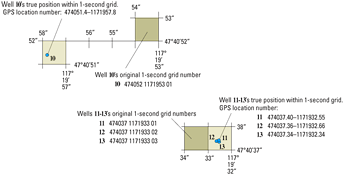
The USGS well- and miscellaneous system is based on latitude and longitude. A unique 15-digit number is assigned for each site: the first six digits denote degrees, minutes, and seconds of latitude; the next seven digits denote degrees, minutes, and seconds of longitude; and the last two digits (assigned sequentially) identify the wells within a 1-second grid (fig. 1). Datums are either the North American Datum of 1927 or the North American Datum of 1983, depending on when the site was established; recently assigned site-identification numbers use the North American Datum of 1983. Although the USGS site identification number was established from geographic coordinates, it should not be used to locate a site because the unique site number is permanent and does not change if a more accurate location is determined at a later time.
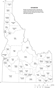
Figure 2 shows the number of wells in Idaho (by county) for which water-level and water-quality data are available for water year 2006. The USGS provides ground-water data online at: http://waterdata.usgs.gov/id/nwis/. In addition, data can be provided in machine-readable formats on various media. Contact us for types and availability of data or products, and user charges:
This report is available online in Portable Document Format (PDF). If you do not have the Adobe Acrobat PDF Reader, it is available for free download from Adobe Systems Incorporated.
Document Accessibility: Adobe Systems Incorporated has information about PDFs and the visually impaired. This information provides tools to help make PDF files accessible. These tools convert Adobe PDF documents into HTML or ASCII text, which then can be read by a number of common screen-reading programs that synthesize text as audible speech. In addition, an accessible version of Acrobat Reader 7.0 for Windows (English only), which contains support for screen readers, is available. These tools and the accessible reader may be obtained free from Adobe at Adobe Access.

![]() U.S. Department of the Interior |
U.S. Geological Survey
U.S. Department of the Interior |
U.S. Geological Survey
Persistent URL: https://pubs.water.usgs.gov/fs20073031
Page Contact Information: Publications Team
Page Last Modified: Tuesday, 29-Nov-2016 18:04:41 EST
