Fact Sheet 2007-3103
Prepared in cooperation with Deschutes County and the Oregon Department of Environmental Quality
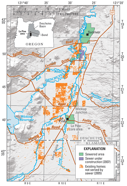
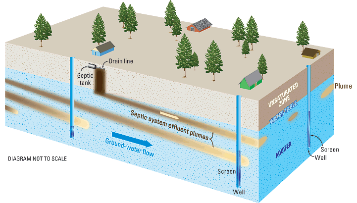
The population of rural residential areas near La Pine in southern Deschutes County and northern Klamath County, Oregon, has grown rapidly since the 1960s. Most of these areas lie within a tract adjacent to the Deschutes and Little Deschutes Rivers that extends roughly 25 miles south of Sunriver (fig. 1). Existing and future homes on more than 9,300 residential lots in the area now use or will use individual, on-site septic systems for wastewater disposal and shallow wells for water supply. At least 50 percent of these wells draw ground water from the upper 50 feet of the shallow aquifer that underlies the area (Morgan and others, 2007).
Vulnerability of the shallow aquifer to contamination has led to concern by residents, County planners and resource managers, and State regulators that wastewater from septic systems may pose a threat to the primary drinking water supply if residential development continues at planned densities using conventional septic systems. Another concern is the quality of local streams (Hinkle, Morgan, and others, 2007). The Deschutes and Little Deschutes Rivers, which flow through the developed areas near La Pine, already have excessive algae in some reaches, possibly due to nutrient (nitrogen and phosphorus) contributions from ground water (Anderson, 2000; Jones, 2003).

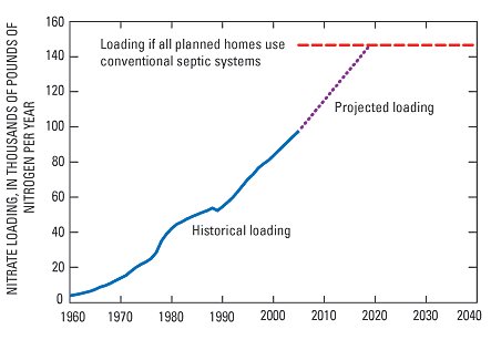
Conventional residential septic systems are the principal source of nitrogen to the shallow aquifer in the La Pine area (Century West Engineering, 1982; Oregon Department of Environmental Quality, 1994; Hinkle, Böhlke, and others, 2007), and the nitrate contribution (loading) to the aquifer from these septic systems has increased rapidly as a result of ongoing residential development (fig. 2). Conventional septic systems, including sand filter and pressure distribution systems, are not designed to remove nitrogen from wastewater. Nitrate is a human health concern because it can cause methemoglobinemia (Blue-Baby Syndrome) in infants (http://www.atsdr.cdc.gov/HEC/CSEM/nitrate/). The U.S. Environmental Protection Agency has established 10 parts per million (ppm) of nitrogen as the maximum allowable nitrate concentration in drinking water for public water supply systems. Oregon law sets a nitrate concentration of 7 ppm as the level at which regulatory action must be taken to control water-quality degradation.
The city of La Pine was the location of the first concentrated development within the area. The first building permits, recorded in what was then called the core area, date from 1910. In 2006, the core area was incorporated as the City of La Pine. The Oregon Department of Environmental Quality (ODEQ) issued an administrative rule requiring community sewage treatment for the core area after studies in 1979 and 1982 documented nitrate contamination in drinking water wells (Century West Engineering, 1982; Cole, 2006).
Surveys of wells outside of the core area by ODEQ between 1993 and 1995 found unnaturally elevated nitrate concentrations in several of the most densely developed parts of the region (R.J. Weick, ODEQ, written commun., 1998; Cole, 2006). The high concentrations were attributed to contamination by effluent from septic systems.
In 1999, Deschutes County and ODEQ identified the need for a better understanding of the processes that affect the movement and chemistry of nitrogen in the aquifer underlying the La Pine area in order to develop strategies for managing ground-water quality. In response, the USGS, in cooperation with Deschutes County and ODEQ, began a study in 1999 to examine the hydrologic and chemical processes that affect the movement and fate (chemical transformation) of nitrogen within the aquifer (Hinkle, Böhlke, and others, 2007; Morgan and others, 2007). A primary objective was to provide tools for evaluating the effects of existing and future residential development on water quality. The study has provided area residents and local and State agencies the information and tools needed to make informed decisions about the future of development in the La Pine area. Results from the study have been published in several reports (see References Cited). This fact sheet summarizes the results that relate to the effects of septic systems on water quality in the area.
Yes, several factors contribute to the vulnerability:
Ground water moves slowly through the shallow aquifer. Because ground water moves slowly, it takes a long time for nitrate to appear in well water.
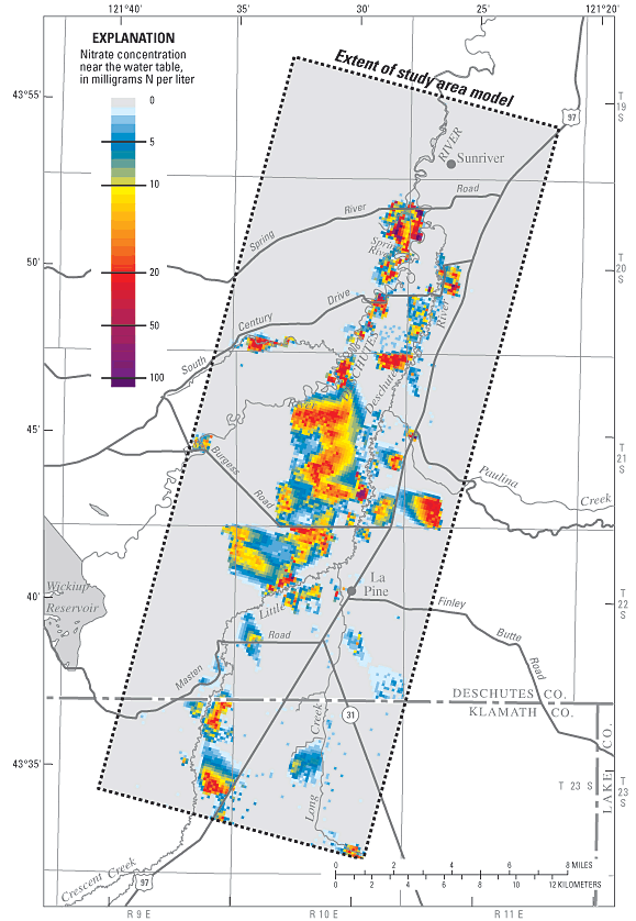
For example, the severity of nitrate contamination in the La Pine core area did not become evident until 1979, nearly 70 years after development of that area began. Away from the core area, most wells currently provide drinking water that percolated to the water table decades ago, when there were very few homes and septic systems. Nitrate plumes, however, are beginning to affect a significant number of drinking-water wells. Of nearly 200 well samples collected by ODEQ in 2000, over 10 percent had nitrate concentrations above 4 ppm, indicating contamination from septic systems.
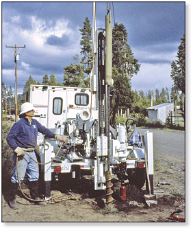
Much of the nitrate in the aquifer currently is confined to plumes less than about 30 feet below the water table, so not all supply wells are drawing water from affected areas of the aquifer (fig. 3). As development proceeds and the nitrate plumes expand and move deeper into the aquifer, more wells will be affected. Age dating of ground water in the La Pine area provides additional insight into this process. USGS scientists determined the age of ground water by sampling special monitoring wells and analyzing the water for tracers called chlorofluorocarbons (common refrigerant gases found in the atmosphere). These tracers indicate that nitrate from septic systems is moving downward into deeper parts of the aquifer where more wells will be affected in the future (Hinkle, Böhlke, and others, 2007; Morgan and others, 2007).
Probably not. Several lines of evidence point to septic systems as the main source of the nitrate (Hinkle, Böhlke, and others, 2007):
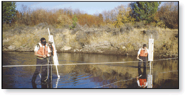 These scientists are measuring the flow of ground water into the Little Deschutes River through the streambed. |
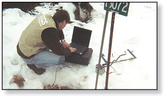 The USGS measured water levels in the aquifer under the La Pine area to determine the direction of ground-water flow. |
Large areas of the shallow aquifer will have nitrate concentrations above 10 ppm, and more nitrate will be carried into streams by ground water.
If residential development proceeds as planned and no efforts are made to reduce the rates of nitrate loading from septic systems, loading is projected to increase 52 percent above 2005 rates (fig. 2). Computer model simulations of this future scenario show that:
The computer model integrates the current understanding of nitrogen geochemistry, hydrology, and geology of the aquifer underlying the La Pine area. The model was tested by simulating past ground-water levels, ground-water travel times, ground-water discharge to streams, and ground-water-quality conditions and then comparing the model results with measurements made in the study area. The simulated conditions, including past ground-water nitrate concentrations, matched measured conditions within acceptable limits. These results indicate that the model has sufficient accuracy to be a valid tool for evaluating the potential effects of septic systems on future ground-water quality.
The computer model is a tool that can be used to help answer this question.
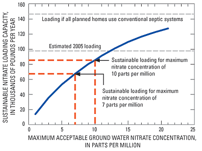
The capacity of the aquifer to receive nitrate varies throughout the area and depends on factors related to geology, climate, chemistry, and nearby development. These factors are accounted for by the model, allowing it to compute the maximum sustainable nitrate loading capacity in each of 95 subareas ranging in size from 160 to 640 acres. The maximum sustainable loading capacity also depends on the water-quality protection goals for the aquifer. Model users set the values of water-quality goals, which can be the maximum acceptable nitrate concentration in ground water, the maximum acceptable discharge of nitrate to streams, or both. Goals that are more protective, such as limiting nitrate concentrations in ground water to 7 ppm instead of 10 ppm, reduce the sustainable loading capacity of the aquifer (fig. 5). The model can be used to examine the trade-offs between more stringent water-quality goals and the costs of limiting nitrate loading. Planners and resource managers also can use the model to identify areas where loading from planned or existing development exceeds the sustainable nitrate loading capacity of the aquifer and devise appropriate strategies for reducing loading.
Anderson, C.W., 2000, Framework for regional, coordinated monitoring in the middle and upper Deschutes River basins, Oregon: U.S. Geological Survey Open-File Report 00-386, 81 p.
Century West Engineering, 1982, La Pine aquifer management plan: Bend, Oregon, Century West Engineering, 597 p.
Cole, D.L., 2006, Groundwater quality report for the Deschutes basin, Oregon: Oregon Department of Environmental Quality Laboratory and Water Quality Division, 54 p.; also available online at http://www.deq.state.or.us/lab/techrpts/groundwater/dbgroundwater/dbgwreport.pdf, last accessed November 9, 2007.
Hinkle, S.R., Böhlke, J.K., Duff, J.H., Morgan, D.S., and Weick, R.J., 2007, Aquifer scale controls on the distribution of nitrate and ammonium in ground water near La Pine, Oregon, USA: Journal of Hydrology, v. 333, p. 486503.
Hinkle, S.R., Morgan, D.S., Orzol, L.L., and Polette, D.J., 2007, Ground water redox zonation near La Pine, OregonRelation to river position within the aquiferriparian zone continuum: U.S. Geological Survey Scientific Investigations Report 20075239, 28 p.; last accessed November 9, 2007, at https://pubs.usgs.gov/sir/2007/5239/.
Jones, Lesley, 2003, Characterization of select water quality parameters within the upper Deschutes and Little Deschutes study areas: Upper Deschutes Watershed Council Bend, Oregon: 2003, 127 p.
Morgan, D.S., Hinkle, S.R., and Weick, R.J., 2007, Evaluation of approaches for managing nitrate loading from on-site wastewater systems near La Pine, Oregon: U.S. Geological Survey Scientific Investigations Report 20075237, 64 p.; also available online at https://pubs.usgs.gov/sir/2007/5237/, last accessed November 9, 2007.
Oregon Department of Environmental Quality, 1994, Statewide groundwater monitoring program, La Pine area groundwater investigation, Deschutes County, Oregon: Portland, Oregon Department of Environmental Quality, v. II, variously paginated.
Base Credits for figures 1 and 4.
Base modified from U.S. Geological Survey
1:500,000 state base map, 1982 with digital data from U.S. Bureau of the Census,
TIGER/Line (R), 1990 and U.S. Geological Survey Digital Line Graphs published at 1:100,000
Publication projection is Lambert Conformal Conic, Standard parallels 42º20 and 44º40,
central meridian -120º30. Datum is NAD83
John S. Williams, David S. Morgan, and Stephen R. Hinkle
Illustrations by Jacqueline Olson and Robert Crist
Editing by Debra Grillo
Graphic Design by Bill Gibbs
For more information, contact:
U.S. Geological Survey
Oregon Water Science Center
601 SW 2nd Ave, Suite 1950, Portland, Oregon 97204
GS-W-OR_Inquiries@usgs.gov
This report is available online in Portable Document Format (PDF). If you do not have the Adobe Acrobat PDF Reader, it is available for free download from Adobe Systems Incorporated.
Document Accessibility: Adobe Systems Incorporated has information about PDFs and the visually impaired. This information provides tools to help make PDF files accessible. These tools convert Adobe PDF documents into HTML or ASCII text, which then can be read by a number of common screen-reading programs that synthesize text as audible speech. In addition, an accessible version of Adobe Reader 8.0 for Windows (English only), which contains support for screen readers, is available. These tools and the accessible reader may be obtained free from Adobe at Adobe Access.

![]() U.S. Department of the Interior | U.S. Geological Survey
U.S. Department of the Interior | U.S. Geological Survey
URL: https://pubs.usgs.gov/fs/2007/3103
Page Contact Information: Publications Team
Page Last Modified:
Wednesday, 17-Sep-2025 14:23:50 EDT
