Fact Sheet 20083005
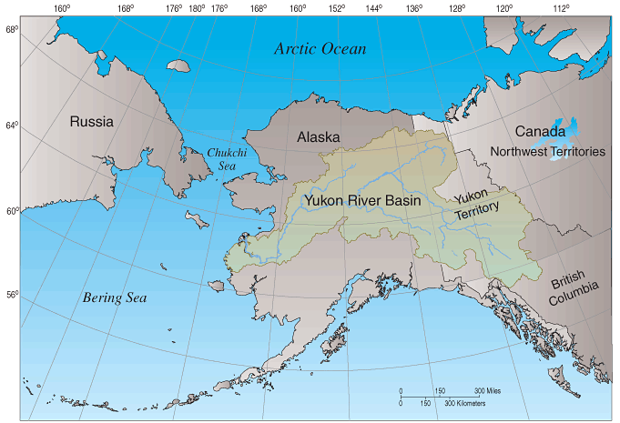
In 2001, the U.S. Geological Survey (USGS) began a water-quality study of the Yukon River. The Yukon River Basin (YRB), which encompasses 330,000 square miles in northwestern Canada and central Alaska (fig. 1), is one of the largest and most diverse ecosystems in North America. The Yukon River is more than 1,800 miles long and is one of the last great uncontrolled rivers in the world, and is essential to the eastern Bering Sea and Chukchi Sea ecosystems, providing freshwater runoff, sediments, and nutrients (Brabets and others, 2000). Despite its remoteness, recent studies (Hinzman and others, 2005; Walvoord and Striegl, 2007) indicate the YRB is changing. These changes likely are in response to a warming trend in air temperature of 1.7°C from 1951 to 2001 (Hartmann and Wendler, 2005). As a result of this warming trend, permafrost is thawing in the YRB, ice breakup occurs earlier on the main stem of the Yukon River and its tributaries, and timing of streamflow and movement of carbon and sediment through the basin is changing (Hinzman and others, 2005; Walvoord and Striegl, 2007).
One of the most striking characteristics in the YRB is its seasonality. In the YRB, more than 75 percent of the annual streamflow runoff occurs during a five month period, May through September. This is important because streamflow determines when, where, and how much of a particular constituent will be transported. As an example, more than 95 percent of all sediment transported during an average year also occurs during this period (Brabets and others, 2000). During the other 7 months, streamflow, concentrations of sediment and other water-quality constituents are low and little or no sediment transport occurs in the Yukon River and its tributaries.
Streamflow and water-quality data have been collected at more than 50 sites in the YRB (Dornblaser and Halm, 2006; Halm and Dornblaser, 2007). Five sites have been sampled more than 30 times and others have been sampled twice during peak- and low-flow conditions as part of synoptic sampling campaigns. Although the synoptic data do not provide a complete picture of water quality of a particular river through the year, the data do provide a snapshot of water-quality conditions at a particular time of year.
Two constituents of interest are suspended sediment and dissolved organic carbon (DOC). Suspended sediment is important because elevated concentrations can adversely affect aquatic life by obstructing fish gills, covering fish spawning sites, and altering habitat of benthic organisms. Metals and organic contaminants also tend to adsorb onto fine-grained sediment. Permafrost thawing has major implications for the carbon cycle. It is critical to understand the processes related to the transport of DOC to surface waters and how long-term climatic changes may alter these processes (Schuster and others, 2004).
The following description of the suspended sediment, DOC, and streamflow characteristics of the YRB starts near the headwaters of the Yukon River at Whitehorse, Yukon Territory, Canada (fig. 2), about 1,800 miles from the mouth of the Yukon River. Suspended sediment, DOC, and streamflow data collected since 2001, and historical streamflow and water-quality data, were used to explain these characteristics.
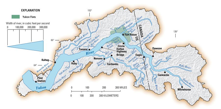
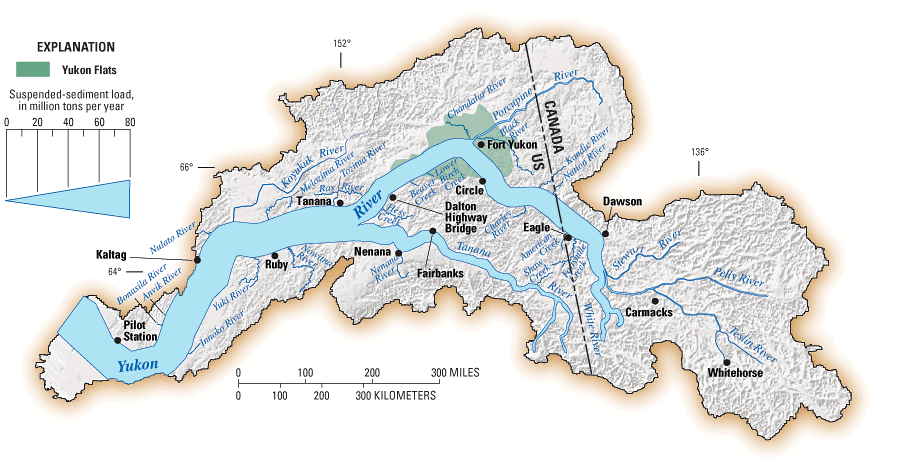
Yukon River at Whitehorse, Yukon Territory, CanadaAt Whitehorse (fig. 2), the Yukon River drains less than 4 percent of the basin and streamflow averages 8,600 cubic feet per second (ft3/s). Streamflow primarily is through large headwater lakes that trap much of the sediment before it enters the Yukon River. Suspended sediment concentrations generally are less than 15 milligrams per liter (mg/L) and the annual suspended sediment load is about 0.1 percent (62,000 tons) of the total annual load at Pilot Station, Alaska (fig. 3). DOC concentrations generally are low in the Yukon River because this part of the YRB contains only sporadic masses of permafrost and only a few wetland areas.
Yukon River at Dawson, Yukon Territory, CanadaAt Dawson (fig. 2), about 1,300 miles from the mouth, the Yukon River drains almost one-third of the basin and streamflow averages 78,000 ft3/s. The major tributaries between Whitehorse and Dawson are the Teslin, Pelly, White, and Stewart Rivers. The White River, the smallest of these basins, is glacier-fed and has the greatest average streamflow (20,000 ft3/s) (fig. 2). Glacier-fed rivers such as the White River transport higher amounts of suspended sediment than non-glacier-fed rivers. The White River transports 19 million tons of suspended sediment per year in the upper part of its basin (fig. 3). In comparison, non-glacier-fed rivers, such as the Pelly and Stewart Rivers transport 2.5 and 2.0 million tons of suspended sediment per year, respectively (fig. 3). Downstream of the confluence of the White and Yukon Rivers, the clarity of the Yukon River changes dramatically, remaining sediment laden for its entire reach to the Bering Sea. Synoptic samples from the Teslin, Pelly, White, and Stewart Rivers, and other small tributaries showed DOC concentrations at about 5 mg/L in this reach of the Yukon River. However, DOC was not measured during the snowmelt peak, usually the time of largest DOC concentrations.
Yukon River at Eagle, AlaskaAbout 100 miles downstream of Dawson, Yukon Territory, the Yukon River flows past the town of Eagle, Alaska. From Whitehorse to Eagle, the average streamflow of the Yukon River increases about 1 order of magnitude to 84,000 ft3/s, representing about 37 percent of the total annual average YRB streamflow (fig. 2). Suspended sediment loads increase to nearly 70 percent of the total annual average from the YRB (about 45 million tons per year), one order of magnitude greater than the Yukon River upstream of the White River (fig. 3). This is the first location on the Yukon River where annual DOC loads can be calculated: 450,000 tons per year, representing about 25 percent of the total annual DOC load from the YRB (Striegl and others, 2007). DOC concentrations were smallest during winter months (less than 2 mg/L) and highest during mid-May (8.514 mg/L), the beginning of snowmelt. Relatively large DOC concentrations (about 20 mg/L in June 2004 and about 16 mg/L in August 2004) were measured in the Fortymile River between Dawson and Eagle, possibly indicating a significant source of DOC from this tributary.
Yukon River at Circle, AlaskaBetween Eagle and Circle the Yukon River flows through a somewhat narrow stretch of the basin. The major tributariesNation, Kandik, and Charley Riversare relatively clear streams in small watersheds, and add little suspended sediment to the Yukon River. However, DOC concentrations greater than 10 mg/L during June 2003 were measured in these tributaries, perhaps indicating the presence of wetlands or initial thawing of the permafrost in these basins. About 1,100 miles from the mouth of the Yukon River, the town of Circle, Alaska, marks the beginning of the Yukon Flats, an extensive wetland about the size of Connecticut.
Yukon River at Fort Yukon, AlaskaAbout 1,000 miles from the mouth of the Yukon River, this is the mid-point of the Yukon Flats. No major tributaries to the Yukon River are between Circle and Fort Yukon. The Porcupine River, the largest tributary basin in the YRB (45,000 mi2) enters the Yukon River at Fort Yukon and has an average streamflow of 17,100 ft3/s. The Porcupine River basin is underlain mostly by permafrost and is a major source of DOC into the Yukon River. Although DOC concentrations are less than 2.0 mg/L during the winter, large DOC concentrations (28 mg/L) were measured during peak discharge from spring snowmelt. Measured suspended-sediment concentrations have been about 200 mg/L during spring snowmelt, about one-fifth of the concentrations measured in the White River. The Porcupine Rivers average annual suspended-sediment load (4 million tons per year) is less than one-tenth that of the Yukon River at Eagle (fig. 3). However, the annual DOC load for the Porcupine River is 139,000 tons per year, which increases the DOC load from the Yukon River at Eagle by 25 percent, suggesting that the Porcupine River is the first major source of DOC to the Yukon River.
Yukon River at Dalton Highway Bridge, AlaskaThe Yukon River exits the Yukon Flats at the Dalton Highway Bridge, about 800 miles from its mouth. Here, the Yukon River drains about 60 percent of the YRB with an average streamflow of 119,000 ft3/s, representing about one-half the total annual average discharge from the YRB (fig. 2). Major tributaries between the Yukon River at Fort Yukon and the Dalton Highway Bridge are the Chandalar River, Beaver Creek, and Lower Birch Creek. Concentrations of DOC for these tributaries were greater than 10 mg/L, reflecting extensive wetlands, organic-rich soils, and possibly thawing permafrost of the Yukon Flats region. At the Dalton Highway Bridge, suspended sediment loads decrease from a combined annual average of 49 million tons at Eagle and at the mouth of the Porcupine River to 41 million tons per year (fig. 3). Although suspended sediment loads are highly variable, this decrease suggests that the Yukon Flats may act as a sediment sink. DOC loads, however, are about double that from Eagle at 860,000 tons per year, suggesting that tributaries such as the Porcupine River that enter the Yukon River between Eagle and the Dalton Highway Bridge are major sources of DOC to the Yukon River.
Yukon River at Ruby, AlaskaAt Ruby, about 600 miles from its mouth, the Yukon River drains about 73 percent of the Yukon Basin (259,000 mi2) and has an average streamflow of 167,000 ft3/s, representing nearly 75 percent of the streamflow from the YRB (fig. 2). The Tanana River, a glacier-fed river, is the second largest tributary basin (44,300 mi2) and flows into the Yukon River about 100 miles upstream of Ruby. Between the Dalton Highway Bridge and Ruby, streamflow in the Yukon River increases about 37 percent, mostly due to the Tanana River (average streamflow 41,400 ft3/s) (fig. 2). Other major tributaries are Hess Creek, and the Tozitna, Nowitna, and Melozitna Rivers. DOC concentrations measured at these sites were greater than 10 mg/L, indicating this part of the Yukon River may be a significant source of DOC. The annual suspended sediment load of the Tanana River is about 37 million tons, about one-half the annual average sediment load from the entire YRB, indicating that the Tanana River is a significant source of suspended sediment to the Yukon River (fig. 3). The annual DOC load of the Tanana River at Nenana is 88,000 tons, much less than the DOC load from the Porcupine River, and only about 5 percent of the annual average DOC load from the YRB, indicating that this large glacier-fed river does not provide a large amount of DOC to the Yukon River.
Yukon River at Kaltag, AlaskaAt Kaltag, about 450 miles from its mouth, the Yukon River drains nearly 90 percent of the YRB (296,000 mi2) and the average annual streamflow represents 95 percent of the total from the YRB (216,500 ft3/s) (fig. 2). A major tributary to the Yukon River in this area is the Koyukuk River, the third largest drainage in the YRB (31,400 mi2). Other major tributaries are the Yuki and Nulato Rivers. Average streamflow of the Koyukuk River is about 10 percent of the Yukon Rivers streamflow at Kaltag (fig. 2). Annual sediment load is 2 million tons per year (fig. 3). The Koyukuk River also may be a significant source of DOC to the Yukon River. The Koyukuk River is similar to the Porcupine River; both basins are underlain by continuous permafrost. During spring snowmelt, DOC concentrations were greater than 10 mg/L at streamflows greater than 100,000 ft3/s (June 2003), similar to the Porcupine River, and provided a large amount of DOC to the Yukon River.
Yukon River at Pilot Station, AlaskaThe lower reach of the Yukon River between Kaltag and Pilot Station is in a narrow part of the basin and the drainage is increased by only 25,000 mi2 to a total of 321,000 mi2. Major tributaries between these two villages are the Anvik, Bonasila, and Innoko Rivers. The Innoko River drains a large wetland area (14,000 mi2) and measured concentrations of DOC were 15 mg/L near peak snowmelt discharge in June 2003, indicating this basin may be a significant source of DOC to the Yukon River. The Yukon River at Pilot Station, about 120 miles from its mouth, is considered the lowest reach of the river where streamflow is not affected by the Bering Sea. Here, the Yukon River is considered the outflow point for the entire YRB. Average streamflow is 227,500 ft3/s at the Yukon River at Pilot Station. Suspended-sediment load averages 74 million tons per year and DOC loads average 1.7 million tons per year.
The Yukon River provides a daily average of about 228,000 ft3/s of water to the Bering Sea. This large North American river also transports an average of 74 million tons of suspended sediment and 1.7 million tons of DOC each year (based on a 5-year record, 200105). Downstream of the confluence of the White River and the Yukon River, the clarity of the Yukon River changes markedly, remaining sediment laden for its entire reach to the Bering Sea. The White and Tanana Rivers, the two largest glacier-fed rivers in the basin, supply most of the suspended sediment to the Yukon River. A number of tributaries are characterized by concentrations of DOC greater than 10 mg/L, possibly indicating that these streams and rivers may provide significant amounts of DOC to the Yukon River. The Porcupine River basin underlain by continuous permafrost, contributes about 50 percent more DOC than the Tanana River, a basin of similar size underlain by discontinuous permafrost. Basins dominated by permafrost or wetlands may be the largest contributors of DOC to the Yukon River.
Brabets, T.P., Wang, B., and Meade, R.H., 2000, Environmental and hydrologic overview of the Yukon River Basin, Alaska and Canada: U.S. Geological Survey Water-Resources Investigations Report 994204, 106 p.
Dornblaser, M.M., and Halm, D.R., 2006, Water and sediment quality of the Yukon River and its tributaries from Eagle to St. Marys, Alaska, 20022003: U.S. Geological Survey Open-File Report 20061228, 213 p.
Halm, D.R., and Dornblaser, M.M., 2007, Water and sediment quality in the Yukon River and its tributaries between Atlin, British Columbia, Canada, and Eagle, Alaska, 2004: U.S. Geological Survey Open-File Report 20071197, 120 p.
Hartmann, B., and Wendler, G., 2005, The significance of the 1976 Pacific climate shift in the climatology of Alaska: Climate, v. 18, p. 48244839.
Hinzman, L.D., and others, 2005, Evidence and implications of recent climate change in northern Alaska and other Arctic Regions: Climatic Change, v. 72, p. 251298.
Schuster, P.F., Reddy, M.M., Aiken, G.R., and Shanley, J.B., 2004, What effect does permafrost have on dissolved organic carbon transport to streams during snowmelt? in Wanty, R.B., and Seal, R.R. III, eds., Water-rock interaction: Eleventh International Symposium on Water-Rock Interaction, WRI-11, Saratoga Springs, New York, June 27July 2, 2004, [Proceedings], p. 1385-1389.
Striegl, R.G., Dornblaser, M.M., Aiken, G.R., Wickland, K.P., and Raymond, P.A., 2007, Carbon export and cycling by the Yukon, Tanana, and Porcupine Rivers, Alaska, 2001-2005: Water Resources Research, v. 43, W02411, doi:10.1029/2006WR005201, 9 p.
Walvoord, M.A., and Striegl, R.G., 2007, Increased groundwater to stream discharge from permafrost thawing in the Yukon River BasinPotential impacts on lateral export of carbon and nitrogen: Geophysical Research Letters, v. 34, L12402, doi:10:1029/2007/GL030216.
Authors: Timothy P. Brabets and Paul F. Schuster
Design by: Bill Gibbs
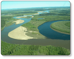
Yukon Flats near Ft. Yukon - Photograph courtesy of Paul Schuster, USGS
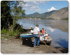
USGS personnel at Eagle, Alaska - Photograph courtesy of Paul Schuster, USGS
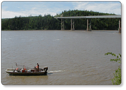
USGS personnel at Dalton Highway Bridge - Photograph courtesy of Mark Dornblaser, USGS
For more information:
USGS Alaska Science Center
4230 University Dr., Suite 201
Anchorage, AK 99508-4650
(907)786-7000
http://alaska.usgs.gov
This report is available online in Portable Document Format (PDF). If you do not have the Adobe Reader, it is available for free download from Adobe Systems Incorporated.
Document Accessibility: Adobe Systems Incorporated has information about PDFs and the visually impaired. This information provides tools to help make PDF files accessible. These tools convert Adobe PDF documents into HTML or ASCII text, which then can be read by a number of common screen-reading programs that synthesize text as audible speech. In addition, an accessible version of Adobe Reader 8.0 for Windows (English only), which contains support for screen readers, is available. These tools and the accessible reader may be obtained free from Adobe at Adobe Access.

![]() U.S. Department of the Interior |
U.S. Geological Survey
U.S. Department of the Interior |
U.S. Geological Survey
URL: https://pubs.usgs.gov/fs/2008/3005
Page Contact Information: Publications Team
Page Last Modified: Tuesday, 29-Nov-2016 18:18:54 EST
