Fact Sheet 2008-3014
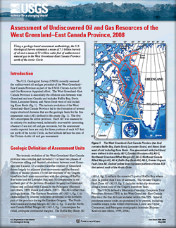 
The U.S. Geological Survey (USGS) recently assessed the undiscovered oil and gas potential of the West Greenland–East Canada Province as part of the USGS Circum-Arctic Oil and Gas Resource Appraisal effort. The West Greenland–East Canada Province is essentially the offshore area between west Greenland and east Canada and includes Baffin Bay, Davis Strait, Lancaster Sound, and Nares Strait west of and including Kane Basin. The tectonic evolution of the West Greenland–East Canada Province led to the formation of several major structural domains that are the geologic basis for the five assessment units (AU) defined in this study. The five AUs encompass the entire province. Each AU was assessed in its entirety for undiscovered, technically recoverable (assuming absence of sea ice) oil and gas resources, but the assessment results reported here are only for those portions of each AU that are north of the Arctic Circle, as that latitude defines the area of the Circum-Arctic oil and gas assessment. |
Version 1.0 Posted May 2008 |
Schenk, C.J., Bird, K.J., Brown, P.J., Charpentier, R.R., Gautier, D.L., Houseknecht, D.W., Klett, T.R., Pawlewicz, M.J., Shah, A., and Tennyson, M.E., 2008, Assessment of undiscovered oil and gas resources of the West Greenland–East Canada Province, 2008: U.S. Geological Survey Fact Sheet 2008–3014, 2 p.
| Document Accessibility: Part or all of this report is presented in Portable Document Format (PDF); the latest version of Adobe Acrobat Reader or similar software is required to view it. Download the latest version of Acrobat Reader, free of charge or go to access.adobe.com for free tools that allow visually impaired users to read PDF files. |
