Fact Sheet 2008–3018
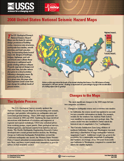 
The U.S. Geological Survey recently updated the National Seismic Hazard Maps by incorporating new seismic, geologic, and geodetic information on earthquake rates and associated ground shaking. The 2008 versions supersede those released in 1996 and 2002. These maps are the basis for seismic design provisions of building codes, insurance rate structures, earthquake loss studies, retrofit priorities, and land-use planning. Their use in design of buildings, bridges, highways, and critical infrastructure allows structures to better withstand earthquake shaking, saving lives and reducing disruption to critical activities following a damaging event. The maps also help engineers avoid costs from over-design for unlikely levels of ground motion. |
Version 1.0 Posted April 2008 |
Petersen, M.D., and others, 2008, 2008 United States National Seismic Hazard Maps: U.S. Geological Survey Fact Sheet 2008–3018, 2 p.

![]() U.S. Department of the Interior | U.S. Geological Survey
U.S. Department of the Interior | U.S. Geological Survey
URL: http://pubsdata.usgs.gov/pubs/fs/2008/3018/index.html
Questions or Assistance: Contact USGS
Last modified: Tuesday, 29-Nov-2016 18:19:34 EST
