Fact Sheet 2008–3031
|
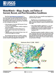
IntroductionWaterWatch (http://water.usgs.gov/waterwatch/) is a U.S. Geological Survey (USGS) World Wide Web site that displays maps, graphs, and tables describing real-time, recent, and past streamflow conditions for the United States. The real-time information generally is updated on an hourly basis. WaterWatch provides streamgage-based maps that show the location of more than 3,000 long-term (30 years or more) USGS streamgages; use colors to represent streamflow conditions compared to historical streamflow; feature a point-and-click interface allowing users to retrieve graphs of stream stage (water elevation) and flow; and highlight locations where extreme hydrologic events, such as floods and droughts, are occurring. The streamgage-based maps show streamflow conditions for real-time, average daily, and 7-day average streamflow. The real-time streamflow maps highlight flood and high flow conditions. The 7-day average streamflow maps highlight below-normal and drought conditions. WaterWatch also provides hydrologic unit code (HUC) maps. HUC-based maps are derived from the streamgage-based maps and illustrate streamflow conditions in hydrologic regions. These maps show average streamflow conditions for 1-, 7-, 14-, and 28-day periods, and for monthly average streamflow; highlight regions of low flow or hydrologic drought; and provide historical runoff and streamflow conditions beginning in 1901. WaterWatch summarizes streamflow conditions in a region (state or hydrologic unit) in terms of the long-term typical condition at streamgages in the region. Summary tables are provided along with time-series plots that depict variations through time. WaterWatch also includes tables of current streamflow information and locations of flooding. For more information concerning the fact sheet, please contact Harry Lins. |
This document is available online only in Portable Document Format (PDF); the latest version of Adobe Acrobat® Reader or similar software is required to view it. Download the latest version of Acrobat® Reader, free of charge or go to access.adobe.com for free tools that allow visually impaired users to read PDF files.

![]() U.S. Department of the Interior |
U.S. Geological Survey
U.S. Department of the Interior |
U.S. Geological Survey
URL: http://pubsdata.usgs.gov/pubs/fs/2008/3031/index.html
Page Contact Information: Web team
Page Last Modified: Wednesday, 09-Jan-2013 20:02:44 EST