Fact Sheet 2008–3059
 Contents | Citation | More Information
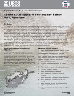
IntroductionA majority of the Afghan population lacks adequate and safe supplies of water because of contamination, lack of water-resources management regulation, and lack of basic infrastructure, compounded by periods of drought and seasonal flooding. Characteristics of historical streamflows are needed to assist with efforts to quantify the water resources of the Helmand Basin. The Helmand Basin is the largest river basin in Afghanistan. It comprises the southern half of the country, draining waters from the Sia Koh Mountains in Herat Province to the eastern mountains in Gardez Province (currently known as the Paktia Province) and the Parwan Mountains northwest of Kabul, and finally draining into the unique Sistan depression between Iran and Afghanistan (Favre and Kamal, 2004). The Helmand Basin is a desert environment with rivers fed by melting snow from the high mountains and infrequent storms. Great fluctuations in streamflow, from flood to drought, can occur annually. Knowledge of the magnitude and time distribution of streamflow is needed to quantify water resources and for water management and environmental planning. Agencies responsible for the development and management of Afghanistan’s surface-water resources can use this knowledge for making safe, economical, and environmentally sound water-resource planning decisions. To provide the Afghan managers with necessary streamflow information, the U.S. Geological Survey (USGS), in cooperation with the U.S. Agency for International Development (USAID), computed streamflow statistics for data collected at historical gaging stations within the Helmand Basin. The historical gaging stations used are shown in figure 1 and listed in table 1. |
Posted July 2008
Download report (1.3 MB pdf) |
Introduction
History of the Streamflow-Gaging Program in Afghanistan
Explanation of Station Summaries
Data Considerations
Report and Data Retrieval
References Cited
Williams-Sether, Tara, 2008, Streamflow characteristics of streams in the Helmand Basin, Afghanistan: U.S. Geological Survey Fact Sheet 2008–3059, 4 p.

![]() U.S. Department of the Interior | U.S. Geological Survey
U.S. Department of the Interior | U.S. Geological Survey
URL: http://pubsdata.usgs.gov/pubs/fs/2008/3059/index.html
Questions or Assistance: Contact USGS
Last modified: Tuesday, 29-Nov-2016 18:21:14 EST
