USGS Fact Sheet 2008-3072
![]() This report is available online in pdf format (1 MB): USGS FS 2008-3072 (
This report is available online in pdf format (1 MB): USGS FS 2008-3072 (![]() ).
).
Report available online only.
U.S. Geological Survey Fact Sheet 2008-3072, 2 pages (Published August 2008)
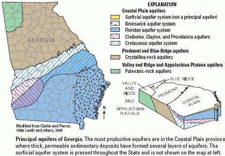 Ground water is an abundant resource in Georgia, providing 1.45 billion gallons per day, or 22 percent, of the total freshwater used (including thermoelectric) in the State (Fanning, 2003). Contrasting geologic features and landforms of the physiographic provinces of Georgia affect the quantity and quality of ground water throughout the State. Most ground-water withdrawals are in the Coastal Plain in the southern one-half of the State, where aquifers are highly productive. For a more complete discussion of the States ground-water resources, see Leeth and others (2005).
Ground-water-level and ground-water-quality data are essential for water-resource assessment and management. Water-level measurements from observation wells are the principal source of information about the hydrologic stresses on aquifers and how these stresses affect ground-water recharge, storage, and discharge. Long-term, systematic measurements of water levels provide essential data needed to evaluate changes in the resource over time; develop ground-water models and forecast trends; and design, implement, and monitor the effectiveness of ground-water management and protection programs (Taylor and Alley, 2001). Ground-water-quality data are necessary to ensure that public water supplies meet health standards; deterioration of ground-water quality may be virtually irreversible, and treatment of contaminated ground water can be expensive (Alley, 1993).
The U.S. Geological Survey (USGS) ground-water network for Georgia currently consists of 175 wells in which ground-water levels are continuously monitored. Most of the wells are located in the Coastal Plain in the southern part of the State where ground-water pumping stress is high. In particular, there are large concentrations of wells in coastal and southwestern Georgia areas, where there are issues related to ground-water pumping saltwater intrusion along the coast, and diminished streamflow in southwestern Georgia due to irrigation pumping. Three coastal wells monitor specific conductance in real time to track position of the chloride plume at Brunswick, Georgia.
Ground-Water Resources
Ground-Water Monitoring Network
Ground-Water Levels
Outlook
References Cited
![]() This report is available online in pdf format (1 MB): USGS FS 2008-3072 (
This report is available online in pdf format (1 MB): USGS FS 2008-3072 (![]() )
)
To view the PDF document, you need the Adobe Acrobat® Reader installed on your computer. (A free copy of the Acrobat® Reader may be downloaded from Adobe Systems Incorporated.)
Recent USGS publications on Georgia or Georgia Water-Resources Information
For more information, please contact webmaster-ga@usgs.gov.

![]() U.S. Department of the Interior |
U.S. Geological Survey
U.S. Department of the Interior |
U.S. Geological Survey
URL: https://pubsdata.usgs.gov/pubs/fs/2008/3072/index.html
Page Contact Information: Publications Team
Page Last Modified: Tuesday, 29-Nov-2016 18:21:40 EST