Skip Links

USGS - science for a changing world

Fact Sheet 2008-3079

CHIPS: Monitoring Colonias Along the United States-Mexico Border in Texas

By Jean W. Parcher

Thumbnail of and link to report PDF (1 MB)

Colonias, which are unincorporated border settlements in
the United States, have emerged in rural areas without the governance and services normally provided by local government. The expansion of colonias in the United States-Mexico border region can be traced to the rapid growth associated with the Mexican Border Industrial Program during the 1960s. This rapid population growth created a lack of affordable housing, causing new migrants in the United States to purchase rural homestead lots through a contract-for-deed program from land developers. Because of the need to keep prices affordable and the absence of effective land-use controls, these homesteads expanded into rural subdivisions, commonly called colonias, without proper infrastructure. Colonias have been identified in the four U.S. border states, with Texas having designated the majority, which numbered over 1,400 colonias in 2001. Because the region is binationally interconnected economically, politically, and socially, the phenomenon of colonias in the United States is a transborder issue.

Version 1.0

Posted October 2008

For additional information contact:

Jean Parcher, jwparcher@usgs.gov
U.S. Geological Survey
8027 Exchange Drive
Austin, Texas 78754-4733

Part or all of this report is presented in Portable Document Format (PDF); the latest version of Adobe Reader or similar software is required to view it. Download the latest version of Adobe Reader, free of charge.


Suggested citation:

Parcher, J.W., 2008, CHIPS: Monitoring Colonias Along the United States-Mexico Border in Texas: U.S. Geological Survey Fact Sheet 2008–3079, 4 p.


Contents

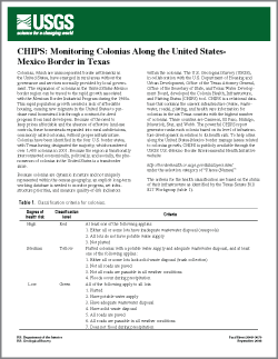
Table 1.  Classification criteria for colonias.


Figure 1.  Distribution of colonias by color classification associated with health risk for the six counties contained in the Colonia Health, Infrastructure, and Platting Status (CHIPS) tool.


Figure 2.  Distribution of green, yellow, and red colonias within Cameron County.


Accessibility FOIA Privacy Policies and Notices

Take Pride in America logo USA.gov logo U.S. Department of the Interior | U.S. Geological Survey
URL: https://pubs.usgs.gov/preview/of/EPNpubTemplate/indexTemplate.html
Page Contact Information: Contact USGS
Page Last Modified: Wednesday, September 24 2008, 03:35:35 PM