Fact Sheet 2008-3098
 |
Select an option: |
|
CONTENTS Overview New Borehole Geophysical Logging Capabilities in Florida FISC Hydrologic Investigations Employing Borehole Geophysical Logging Techniques Hydrogeologic Framework Studies Aquifer Flow-Zone Characterization Freshwater-Saltwater Interface Delineation References Cited
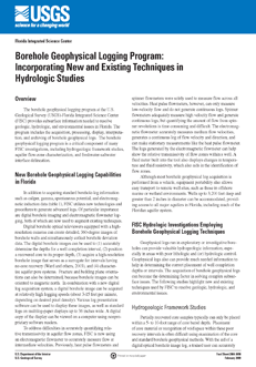
Figure 1. Temporal change in borehole temperature caused by the migration of a tracer
within a touching-vug flow zone at a depth of 41 feet below land surface in an
observation well (modified from Renken and others, 2008). Tracer injection occurred
at 0930 hours. Fluid temperature log at 1252 hours was not completed because the
top of the logging tool was lodged against the casing bottom. |
The borehole geophysical logging program at the U.S. Geological Survey (USGS)-Florida Integrated Science Center (FISC) provides subsurface information needed to resolve geologic, hydrologic, and environmental issues in Florida. The program includes the acquisition, processing, display, interpretation, and archiving of borehole geophysical logs. The borehole geophysical logging program is a critical component of many FISC investigations, including hydrogeologic framework studies, aquifer flow-zone characterization, and freshwater-saltwater interface delineation.
Wacker, M.A., and Cunningham, K.J., 2008, Borehole Geophysical Logging Program: Incorporating New and Existing Techniques in Hydrologic Studies: U.S. Geological Survey Fact Sheet 2008-3098, 4 p.
U.S. Geological Survey
Florida Integrated Science Center
3110 SW 9th Avenue
Ft. Lauderdale, FL 33315
954-377-5900
Michael Wacker at mwacker@usgs.gov or
Kevin Cunningham at kcunning@usgs.gov
| Accessibility FOIA Privacy Policies and Notices | U.S. Department of the Interior, U.S. Geological Survey
Persistent URL: https://pubs.usgs.gov/fs/2008/3098 Page Contact Information: USGS Publishing Service Center Page Last Modified: Tuesday, 29-Nov-2016 18:23:23 EST |
 |