Fact Sheet 2009–3057
Competition for water resources is growing throughout California, particularly in the Central Valley. Since 1980, the Central Valley’s population has nearly doubled to 3.8 million people. It is expected to increase to 6 million by 2020. Statewide population growth, anticipated reductions in Colorado River water deliveries, drought, and the ecological crisis in the Sacramento–San Joaquin Delta have created an intense demand for water. Tools and information can be used to help manage the Central Valley aquifer system, an important State and national resource.The U.S. Geological Survey (USGS) has released results from a study on the largest water reservoir in the State of California, the Central Valley groundwater system. The findings show continued loss of stored groundwater in the southern part of the valley (see figure below). Since about 1960, groundwater has been depleted by almost 60 million acre-feet, which is, on average, enough to supply every resident of California with water for 8 years. 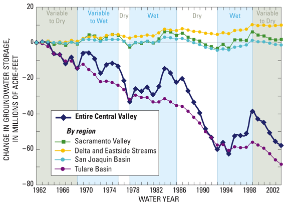 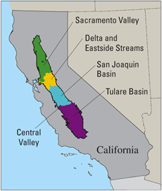
The USGS Groundwater Resources Program funded this study, one of 30 regional aquifer studies the USGS is conducting to assess the Nation’s groundwater availability. Intense competition for groundwater resources in California was an important factor in choosing the Central Valley as one of the first studies undertaken and completed. In order to complete the study, the USGS developed an extensive, detailed three-dimensional (3D) computer model of the hydrologic system of the Central Valley (Faunt, 2009). The Central Valley Hydrologic Model (CVHM) simultaneously accounts for changing water supply and demand across the landscape, and simulates surface water and groundwater flow across the entire Central Valley. This new hydrologic modeling tool can be used by water managers to understand how water moves through the aquifer system, predict water-supply scenarios, and address issues related to water competition in California and the Central Valley including:
The Central Valley Hydrologic ModelThe CVHM is built on knowledge from USGS and other Federal, State, and local studies. The CVHM was constrained by comparing simulated and historically observed groundwater levels, streamflows, and subsidence. The detail and breadth of this hydrologic modeling tool provides a better understanding of valley-wide hydrologic processes. This tool also provides realistic boundary conditions so that finely gridded models of smaller areas can be easily developed.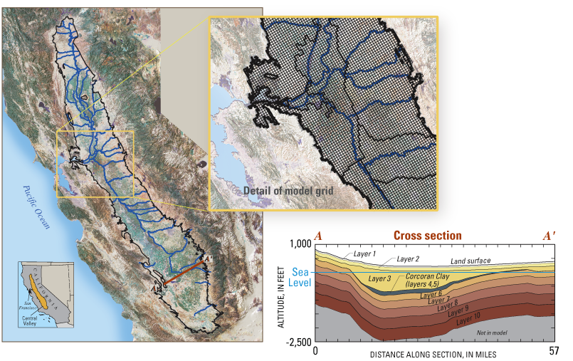
To create enough detail to be practical for water-management decisions, the aquifer was divided spatially into 20,000 model cells of 1 square mile each, and vertically into ten layers ranging in thickness from 50 to 750 feet. Model Features
Farm ProcessThe complex hydrologic system of the Central Valley is simulated by using the USGS hydrologic model, MODFLOW. Combined with the Farm Process, MODFLOW provides a tool to simulate natural and human-induced water movement and consumption over the landscape. Groundwater and surface-water flow are fully coupled. The model accounts for supply-constrained and demand-driven conjunctive use of water in agricultural, urban, and natural settings. In the Central Valley, the tool simulates unmetered historical pumpage and the delivery of surface water for 21 water-balance regions for water years 1962 to 2003. 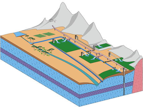
Geospatial DatabaseA comprehensive geospatial database was developed using a Geographic Information System (GIS). The GIS was used to compile, manage, store, and analyze the large quantities of data needed to run the model, and to understand and visualize the data output. Because the 3D groundwater flow model of the heterogeneous Central Valley aquifer system includes complex surface-water management processes, the GIS is extremely useful for recognizing and understanding spatial relations within and among data sets. 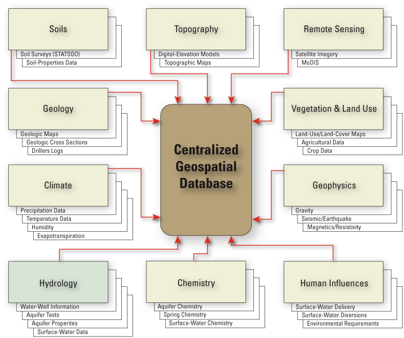
Many different types of data are managed within the Central Valley Hydrologic Model’s extensive Geospatial database. Texture ModelA geologic texture model was developed to characterize the coarseness of valley-fill materials that make up the aquifer system. Lithologic data from approximately 8,500 drillers’ logs of boreholes ranging in depth from 12 to 3,000 feet below land surface, along with other information, were compiled and analyzed. The resulting geologic model was then used to estimate hydraulic properties for every cell in the model. The texture model is key to understanding how water moves through the Central Valley groundwater system. 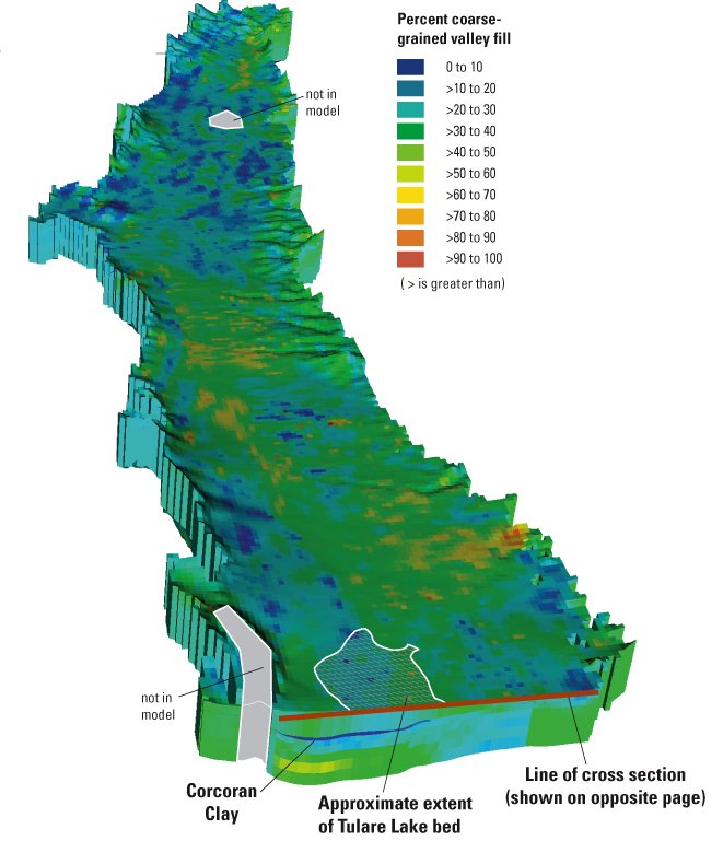 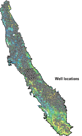
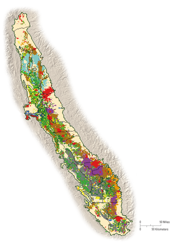
Information from 8,500 drillers’ logs helped scientists create a 3D model of the geologic characteristics of the aquifer system. ResultsStudy results show that human activities such as surface-water deliveries and associated groundwater pumping have a dramatic influence on the present-day Central Valley hydrology. These human activities have increased flow through the groundwater system by roughly a factor of six compared to the pre-development period. Regional differences throughout the hydrologic system can be seen in variations in water availability and land use, and in water-delivery systems. These human activities are often in response to spatial and temporal climate variability. Land Use 2000
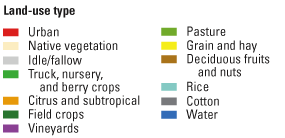
The Central Valley includes urban, native, and agricultural land uses. Because both surface-water and groundwater needs vary by location and land use, the land use affects groundwater availability. 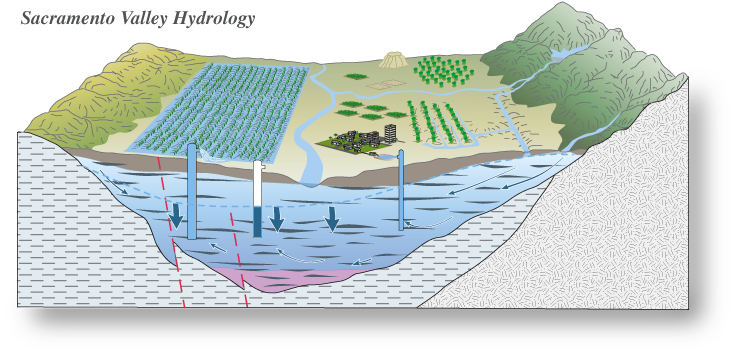
The surface-water delivery system developed for the Central Valley redistributes a significant portion of the water from north to south. The abundance of surface water in the Sacramento Valley results in less pumping, so the Sacramento Valley and the Delta generally have experienced relatively mimimal groundwater-storage depletion. 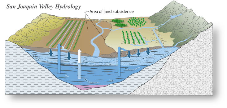
The San Joaquin Valley, which includes the San Joaquin and Tulare Basins, has experienced large changes in groundwater storage. In the early 1960s, groundwater pumping caused water levels to decline to historic lows on the west side of the San Joaquin Valley, which resulted in large amounts of surface subsidence. In the late 1960s, the surface-water delivery system began to route water from the wetter Sacramento Valley and Delta regions to the drier, more heavily pumped San Joaquin Valley. The surface-water delivery system was fully functional by the early 1970s, resulting in groundwater-level recovery in the northern and western parts of the San Joaquin Valley. Overall, the Tulare Basin portion of the San Joaquin Valley, the hottest and driest part of the Central Valley, is still showing declines in groundwater levels and accompanying depletion of groundwater storage. Reference:Faunt, C.C. ed., 2009, Groundwater Availability of the Central Valley Aquifer: U.S. Geological Survey Professional Paper 1766, 225 p. Available at https://pubs.usgs.gov/pp/1766/ —Claudia C. Faunt, Randall T. Hanson, Kenneth Belitz, and Laurel Rogers |
For additional information contact: Part or all of this report is presented in Portable Document Format (PDF); the latest version of Adobe Reader or similar software is required to view it. Download the latest version of Adobe Reader, free of charge. |

![]() U.S. Department of the Interior |
U.S. Geological Survey
U.S. Department of the Interior |
U.S. Geological Survey
URL: http://
pubsdata.usgs.gov
/pubs/fs/2009/3057/index.html
Page Contact Information: GS Pubs Web Contact
Page Last Modified: Tuesday, 29-Nov-2016 17:33:57 EST