Fact Sheet 2009–3087
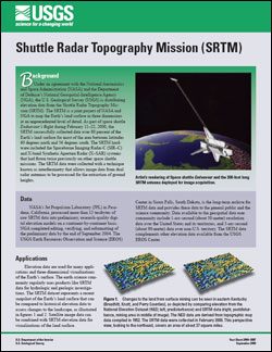
BackgroundUnder an agreement with the National Aeronautics and Space Administration (NASA) and the Department of Defense’s National Geospatial-Intelligence Agency (NGA), the U.S. Geological Survey (USGS) is distributing elevation data from the Shuttle Radar Topography Mission (SRTM). The SRTM is a joint project of NASA and NGA to map the Earth’s land surface in three dimensions at an unprecedented level of detail. As part of space shuttle Endeavour's flight during February 11–22, 2000, the SRTM successfully collected data over 80 percent of the Earth’s land surface for most of the area between latitudes 60 degrees north and 56 degrees south. The SRTM hardware included the Spaceborne Imaging Radar-C (SIR–C) and X-band Synthetic Aperture Radar (X–SAR) systems that had flown twice previously on other space shuttle missions. The SRTM data were collected with a technique known as interferometry that allows image data from dual radar antennas to be processed for the extraction of ground heights. |
Posted September 16, 2009 For additional information contact: Part or all of this report is presented in Portable Document Format (PDF); the latest version of Adobe Reader or similar software is required to view it. Download the latest version of Adobe Reader, free of charge. |
U.S. Geological Survey, 2009, Shuttle Radar Topography Mission (SRTM): U.S. Geological Survey Fact Sheet 2009–3087, 2 p.

![]() U.S. Department of the Interior |
U.S. Geological Survey
U.S. Department of the Interior |
U.S. Geological Survey
URL: http://pubsdata.usgs.gov/pubs/fs/2009/3087/index.html
Page Contact Information: GS Pubs Web Contact
Page Last Modified: Tuesday, 29-Nov-2016 17:35:13 EST
