Fact Sheet 2010–3030
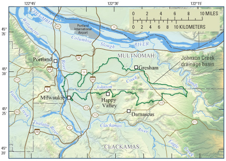 Figure 1. The Johnson Creek basin, Oregon.  Johnson Creek drains diverse landscapes. Top to bottom: Rural upper basin stream, upper basin nursery, commercial/industrial area near the mouth at the Portland–Milwaukie city boundary. (Photographs by Karl Lee, U.S. Geological Survey, August 29, 2003 [top and middle] and January 17, 2007 [bottom].) Johnson Creek forms a wildlife and recreational corridor through densely populated areas of the Portland, Oregon, metropolitan area and through rural and agricultural land in unincorporated Multnomah and Clackamas Counties. Johnson Creek has had a history of persistent flooding and water-quality problems. The U.S. Geological Survey (USGS) has conducted streamflow monitoring and other hydrologic studies in the basin since 1941. Basin DescriptionJohnson Creek is about 26 miles long and drains an area of about 54 square miles (fig. 1). The headwaters as well as the several tributaries on the southern side of the basin originate in volcanic hills. Johnson Creek arises in unincorporated agricultural areas and flows westward through the cities of Gresham, Portland, and Milwaukie, where it enters the Willamette River. The largest tributary is Kelley Creek, which enters Johnson Creek from the south in midbasin (fig. 2). Few tributaries flow into Johnson Creek from the relatively flat area north of the stream because water percolates into the permeable deposits left by massive glacial outburst floods that coursed through the Columbia River basin during the last ice age. The primary northern tributary is Crystal Springs Creek, which enters Johnson Creek about a mile from the mouth. The Johnson Creek basin has a temperate marine climate, with wet winters and dry summers. About two-thirds of the annual precipitation, nearly all rain, falls from November through March. Annual precipitation in the basin decreases with elevation, from more than 60 inches in the uplands of the upper basin to about 40 inches at the mouth of the creek, near sea level. Land cover in the Johnson Creek basin generally follows a gradient from forested, agricultural, and rural-residential areas in the headwaters to urban and industrial development in the lower basin (fig. 2). About three-quarters of the basin is rural and open space; the rest is residential, commercial, and industrial. Urban development in recent years has resulted in the widespread conversion of agricultural lands to residential use. Land cover in the southern part of the basin includes forest, nurseries, row crops, and light to dense urban development. Future expansion of the cities of Gresham, Damascus, Happy Valley, and Portland, and possibly new urban centers, likely will result in conversion of current agricultural and light-residential development to a densely urban land use, if current trends continue. The northern part of the basin that is within the Portland metropolitan area is already densely populated. HydrologyStreamflow in Johnson Creek is derived from precipitation runoff and groundwater discharge. Groundwater discharge is particularly important in maintaining summer flows. In some areas of the Johnson Creek basin, particularly along the northern boundary, the direction of groundwater flow is not toward Johnson Creek or its tributaries but out of the drainage basin toward the lower-elevation Sandy, Columbia, or Willamette Rivers. As a result, recharge to the groundwater system within some areas of the basin does not discharge to Johnson Creek but instead flows out of the basin. The result is lower streamflows in Johnson Creek than might be expected for the amount of precipitation that falls on the basin. Streamflow characteristics in an undeveloped drainage basin are shaped by topography, geology, and land cover. In the upper Johnson Creek basin, prior to human development, most of the precipitation ran off to streams from the steep and relatively impermeable volcanic soils, resulting in a rapid rise and fall in streamflow after storms. In the lower basin, most of the precipitation percolated into the ground and then discharged to streams through the generally flat-lying, permeable flood deposits, resulting in a more muted response to storms than in the upper basin. 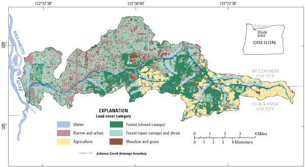 Figure 2. The Johnson Creek basin has a mix of land covers, which grade from forest and agricultural land in the upper basin to urban and industrial development in the lower basin. Modification of the landscape in the Johnson Creek basin has altered its natural hydrology. Delivery of stormwater to the stream in the upper basin is now expedited by agricultural drains and runoff from ditches, roads, and other impermeable surfaces, resulting in a more rapid streamflow increase in response to precipitation than likely occurred before development. In the lower, mostly urban basin, some of the runoff that might otherwise flow to streams across the land surface and in small drainages is directed to the subsurface through infiltration sumps (also known as “drywells”) and to sewer systems that discharge outside the basin. Channel simplification, rock lining of the stream channel, establishment of a network of storm drains, and paving of once-permeable areas also likely have affected runoff volume and response to precipitation. Nonetheless, analysis of streamflow data collected from 1941 to 2006 in the Johnson Creek basin did not detect increases in peak flows and flooding that typically are associated with urban development. This lack of change could be because much of the infrastructure that affects runoff from residential and urban development, such as roads, ditches, drywells, and sewer systems, was in place prior to collection of hydrologic data in the basin. Streamflows are minimal in the Johnson Creek basin during the summer owing to a near lack of precipitation. Summer low flows of Johnson Creek vary from year to year with fluctuations in groundwater discharge to the creek, which are related to annual fluctuations in the amount of recharge from precipitation. Seepage measurements during low-flow periods from 1988 to 2006 indicated small contributions of groundwater to streamflow upstream of river mile 5.5 (about one-half mile west of Interstate Highway 205 [fig. 1]) and relatively large contributions downstream of that point owing to the differences in topography and aquifer characteristics between the upper and middle basins and the lower basin. 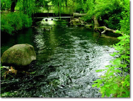 Crystal Springs Creek, shown here near its confluence with Johnson Creek, is one of the largest tributaries to Johnson Creek. (Photograph by Karl Lee, October 1, 2008.) Crystal Springs Creek (fig. 2) is the largest northern tributary to Johnson Creek. Nearly all of Crystal Springs Creek’s flow is supplied by springs and seepage from groundwater discharge that is derived either locally or from the middle or lower basin. Variations in streamflow of the creek over time can be explained by long-term trends in groundwater recharge and subsequent discharge to the creek. Flow increased following record precipitation in 1996 and 1997, and this increase persisted for about 4 years. In 2005, flow was the lowest since measurements began in 1987. A relation was developed during a recent study that provides an estimate of the flow of Crystal Springs Creek based on water level in a nearby well. This information can be used to anticipate both high and low streamflow, for protection of people, property, and wildlife. “Holgate Lake” (as it is known locally) in Southeast Portland appears intermittently, sometimes inundating nearby residences. The lake forms when the water table rises above land surface. The water-surface elevation of Holgate Lake closely follows the elevation of the water table in a nearby observation well equipped with a continuous data recorder. Antecedent water-table elevations, coupled with fall and winter precipitation totals, have been used to predict the lake’s emergence. Water QualitySummer temperatures of Johnson Creek and tributary streams are affected by groundwater discharge, air temperature, and solar radiation. Measurements of the temporal and spatial distribution of groundwater discharge to streams, coupled with comparisons of stream temperature to air temperature, suggest that groundwater discharge cools the stream in some reaches, and that significant warming occurs in stream reaches with shallow, unshaded ponds, such as those in Crystal Springs Creek. High flow in Johnson Creek typically mobilizes sediment and sediment-borne contaminants, including organochlorine pesticides. Upper-basin characteristics, such as more rainfall and runoff, greater slopes, a network of roads and ditches associated with agricultural and rural-residential land uses, and a relative abundance of sources of sediment and sediment-borne contaminants, make management of runoff in the upper part of the basin important to the ecological health of the entire basin. 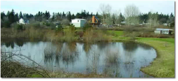 Holgate Lake appears intermittently, during periods when the water table is particularly high. (Photograph by Karl Lee, March 13, 2006.) Organochlorine pesticides were detected in unfiltered samples from Johnson Creek that were collected during a storm in March 2002. Concentrations and loads of the pesticides were largest at the most upstream sampling site, suggesting that agricultural activities were the primary source. Concentrations and loads were smaller at downstream locations, and there were only a few detections from storm drains. Total DDT (the sum of DDT and its metabolites) concentrations potentially exceeded Oregon chronic, freshwater criteria at all stream-sampling sites. The total DDT criterion was also potentially exceeded at an urban storm drain. The use of DDT was banned by the U.S. Environmental Protection Agency in 1972. Concentrations of DDT in water samples from Johnson Creek have decreased by an order of magnitude since previous sampling in 1989–1990. This decrease was probably due to the movement of residual, soil-bound DDT out of the basin and to degradation processes.  High flows in the upper basin mobilize large amounts of sediment. (Photograph by Karl Lee, April 10, 2006.) Selected ReferencesJohnson Creek Watershed Council, 2003, Meet Johnson Creek: accessed March 15, 2010, at http://www.jcwc.org/johnsonCreek/creek.htm. Lee, K.K., and Snyder, D.T., 2009, Hydrology of the Johnson Creek basin, Oregon: U.S. Geological Survey Scientific Investigations Report 2009–5123, 56 p. (Also available at https://pubs.usgs.gov/sir/2009/5123/.) Tanner, D.Q., and Lee, K.K., 2004, Organochlorine pesticides in the Johnson Creek basin, Oregon, 1988–2002: U.S. Geological Survey Scientific Investigations Report 2004–5061, 36 p. (Also available at https://pubs.usgs.gov/sir/2004/5061/.) 
|
For additional information contact: Part or all of this report is presented in Portable Document Format (PDF); the latest version of Adobe Reader or similar software is required to view it. Download the latest version of Adobe Reader, free of charge. |
Williams, J.S., Lee, K.K., and Snyder, D.T., 2010, Hydrology of Johnson Creek basin, a mixed-use drainage basin in the Portland, Oregon, metropolitan area: U.S. Geological Survey Fact Sheet 2010-3030, 4 p.

![]() U.S. Department of the Interior |
U.S. Geological Survey
U.S. Department of the Interior |
U.S. Geological Survey
URL: http://pubsdata.usgs.gov/pubs/fs/2010/3030/index.html
Page Contact Information: GS Pubs Web Contact
Page Last Modified: Tuesday, 29-Nov-2016 17:39:17 EST
