Fact Sheet 2010–3061
Summary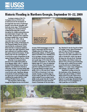
A primary mission of the U.S. Geological Survey (USGS) is the measurement and documentation of the magnitude and extent of hydrologic hazards, such as floods, droughts, and hurricane storm surge. USGS personnel were deployed to document historic, widespread flooding that occurred throughout the Atlanta metropolitan area and northwestern Georgia in the early fall of 2009. The floods were created by prolonged rainfall that occurred during September 16–22, 2009, with an especially intense period of rainfall during the late evening of September 20. The National Weather Service (NWS) reported that the southeastern United States had above-normal precipitation from August into early September, resulting in saturated soil conditions making the region extremely flood prone. Precipitation totals were the sixth highest on record for the month of September for the region (National Weather Service, 2010). Lessons learned from this flood include the need for more effective communication of the latest river information by Federal agencies with flood-threatened communities. Communicating the flood threat in an easy, accessible manner would have helped emergency managers and the public greatly during this flood. In response, the USGS developed WaterAlert (http://water.usgs.gov/wateralert/) to send notifications of flood events by way of text and e-mail. Also in development are real-time flood-inundation maps to give the hydrograph spatial context by way of a map-based product. |
First posted August 4, 2010 For additional information contact: Part or all of this report is presented in Portable Document Format (PDF); the latest version of Adobe Reader or similar software is required to view it. Download the latest version of Adobe Reader, free of charge. |
McCallum, B.E., and Gotvald, A.J., 2010, Historic flooding in northern Georgia, September 16–22, 2009: U.S. Geological Survey Fact Sheet 2010–3061, 4 p.

![]() U.S. Department of the Interior |
U.S. Geological Survey
U.S. Department of the Interior |
U.S. Geological Survey
URL: http://
pubsdata.usgs.gov
/pubs/fs/2010/3061/index.html
Page Contact Information: USGS Publications Team
Page Last Modified: Tuesday, 29-Nov-2016 17:40:32 EST
