Skip Links

USGS - science for a changing world

Fact Sheet 2011–3078
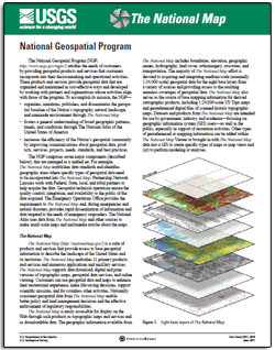
National Geospatial Program

By William J. Carswell, Jr.

Thumbnail of and link to report PDF (371 kB)

Introduction

The National Geospatial Program (NGP; http://www.usgs.gov/ngpo/) satisfies the needs of customers by providing geospatial products and services that customers incorporate into their decisionmaking and operational activities. These products and services provide geospatial data that are organized and maintained in cost-effective ways and developed by working with partners and organizations whose activities align with those of the program. To accomplish its mission, the NGP—

  • organizes, maintains, publishes, and disseminates the geospatial baseline of the Nation's topography, natural landscape, and manmade environment through The National Map
  • fosters a general understanding of broad geographic patterns, trends, and conditions through The National Atlas of the United States of America
  • increases the efficiency of the Nation's geospatial community by improving communications about geospatial data, products, services, projects, needs, standards, and best practices.
The NGP comprises seven major components (described below), that are managed as a unified set. For example, The National Map establishes data standards and identifies geographic areas where specific types of geospatial data need to be incorporated into The National Map. Partnership Network Liaisons work with Federal, State, local, and tribal partners to help acquire the data. Geospatial technical operations ensure the quality control, integration, and availability to the public of the data acquired. The Emergency Operations Office provides the requirements to The National Map and, during emergencies and natural disasters, provides rapid dissemination of information and data targeted to the needs of emergency responders. The National Atlas uses data from The National Map and other sources to make small-scale maps and multimedia articles about the maps.

Revised January 11, 2012

First Posted July 2011

For additional information contact:
Jeff Dietterle
U.S. Geological Survey
511 National Center
Reston, VA 20192
Telephone: (703) 648–5639
E-mail: jdietterle@usgs.gov
Internet: http://nationalmap.gov/

Part or all of this report is presented in Portable Document Format (PDF); the latest version of Adobe Reader or similar software is required to view it. Download the latest version of Adobe Reader, free of charge.


Suggested citation:

Carswell, W.J., Jr., 2011, National Geospatial Program: U.S. Geological Survey Fact Sheet 2011-3078, 2 p., available at https://pubs.usgs.gov/fs/2011/3078/.


Accessibility FOIA Privacy Policies and Notices

Take Pride in America logo USA.gov logo U.S. Department of the Interior | U.S. Geological Survey
URL: http://pubsdata.usgs.gov/pubs/fs/2011/3078/index.html
Page Contact Information: GS Pubs Web Contact
Page Last Modified: Tuesday, 29-Nov-2016 17:45:51 EST