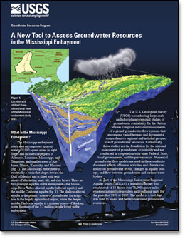
 What is the Mississippi Embayment? What is the Mississippi Embayment?
The Mississippi embayment study area encompasses approximately 78,000 square miles in eight States and includes large parts of Arkansas, Louisiana, Mississippi, and Tennessee, and smaller areas of Alabama, Illinois, Kentucky, and Missouri (fig. 1). The Mississippi embayment is essentially a basin that slopes toward the Gulf of Mexico and is filled with sediments of alternating sand, silt, and clay layers. There are two principal aquifers in the embayment—the Mississippi River Valley alluvial aquifer (alluvial aquifer) and the middle Claiborne aquifer (fig. 1). The shallow alluvial aquifer is the primary source of groundwater for irrigation in the largely agricultural region, while the deeper middle Claiborne aquifer is a primary source of drinking water for many of the 5.2 million people living in the embayment.
The U.S. Geological Survey (USGS) is conducting large-scale multidisciplinary regional studies of groundwater availability for the Nation. Studies comprise individual assessments of regional groundwater-flow systems that encompass varied terrains and document a
comprehensive regional and national perspective of groundwater resources. Collectively, these studies are the foundation for the national assessment of groundwater availability and are conducted in cooperation with other Federal, State, local governments, and the private sector. Numerical groundwater-flow models are used in these studies to document effects of human activities and climate variability on groundwater levels, changes in aquifer storage, and flow between groundwater and surface-water bodies.
As part of the Mississippi Embayment Regional Aquifer Study (MERAS), a numerical model was constructed of 13 layers over 78,000 square miles representing multiple aquifers and confining units for the period of 1870 to 2007. The model is a tool that was used to assess and better understand groundwater resources.
|
First posted November 30, 2011
Part or all of this report is presented in Portable Document Format (PDF); the latest version of Adobe Reader or similar software is required to view it. Download the latest version of Adobe Reader, free of charge. |

