Skip Links

USGS - science for a changing world

Fact Sheet 2012–3005

Watershed Modeling Applications in South Texas

By Diana E. Pedraza and Darwin J. Ockerman

Thumbnail of and link to report PDF (2.49 MB)Abstract

Watershed models can be used to simulate natural and human-altered processes including the flow of water and associated transport of sediment, chemicals, nutrients, and microbial organisms within a watershed. Simulation of these processes is useful for addressing a wide range of water-resource challenges, such as quantifying changes in water availability over time, understanding the effects of development and land-use changes on water resources, quantifying changes in constituent loads and yields over time, and quantifying aquifer recharge temporally and spatially throughout a watershed.

The U.S. Geological Survey (USGS), in cooperation with State and Federal agency partners, developed simulation models for several watersheds in south Texas. These models provide the capability to simulate scenarios of possible future conditions and management alternatives to help water-resource professionals with planning decisions. The program used for creating these Texas watershed models is the Hydrological Simulation Program—FORTRAN (HSPF). HSPF is one of the most comprehensive watershed modeling programs because it can simulate a variety of stream and watershed conditions with reasonable accuracy and enables flexibility in adjusting the model to simulate alternative conditions or scenarios. The HSPF model provides time-series data simulating water movement (runoff from land surfaces, infiltration of water through soil layers, flow in stream channels) and water-quality parameter values and constituent concentrations associated with the water movement at any selected location in the watershed. Time-series outputs from an HSPF simulation are continuous (for example, hourly or daily). Continuous models provide the advantage of simulating watershed processes for a full range of streamflow conditions. Continuous models can illustrate how processes that appreciably affect water-quality conditions during low flows might have relatively minor effects on water-quality conditions during high flows.

This fact sheet presents an overview of six selected watershed modeling studies by the USGS and partners that address a variety of water-resource issues in south Texas. These studies provide examples of modeling applications and demonstrate the usefulness and versatility of watershed models in aiding the understanding of hydrologic systems.

First posted January 10, 2012

For additional information contact:
Director, Texas Water Science Center
U.S. Geological Survey
1505 Ferguson Lane
Austin, Texas 78754-4501
http://tx.usgs.gov/

Part or all of this report is presented in Portable Document Format (PDF); the latest version of Adobe Reader or similar software is required to view it. Download the latest version of Adobe Reader, free of charge.


Suggested citation:

Pedraza, D.E., and Ockerman, D.J., 2012, Watershed modeling applications in south Texas: U.S. Geological Survey Fact Sheet 2012–3005, 4 p.
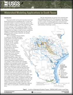

Contents

Introduction

Simulating the Effects of Recharge-Enhancement Structures—Cibolo Creek

A River System Water-Budget Analysis—Lower San Antonio River

A Contaminant-Loading Model for an Urban Stream—Leon Creek

Modeling Suspended-Sediment Loads to Bays and Estuaries—Lower Nueces River

A Total Daily Maximum Load (TMDL) Model—Arroyo Colorado

Modeling Recharge to the Edwards Aquifer—Hondo Creek, Verde Creek, San Geronimo Creek

References Cited

Accessibility FOIA Privacy Policies and Notices

Take Pride in America logo USA.gov logo U.S. Department of the Interior | U.S. Geological Survey
URL: http://pubsdata.usgs.gov/pubs/fs/2012/3005/index.html
Page Contact Information: GS Pubs Web Contact
Page Last Modified: Tuesday, 29-Nov-2016 18:28:16 EST