Skip Links

USGS - science for a changing world

Fact Sheet 2013–3024

Prepared in cooperation with the Middle Pecos Groundwater Conservation District, Pecos County, City of Fort Stockton, Brewster County, and Pecos County Water Control and Improvement District No. 1

A Conceptual Hydrogeologic Model for the Hydrogeologic Framework, Geochemistry, and Groundwater-Flow System of the Edwards-Trinity and Related Aquifers in the Pecos County Region, Texas

By Jonathan V. Thomas, Gregory P. Stanton, Johnathan R. Bumgarner, Daniel K. Pearson, Andrew P. Teeple, Natalie A. Houston, Jason D. Payne, and MaryLynn Musgrove

Thumbnail of and link to report PDF (8.60 MB)

The Edwards-Trinity aquifer is a vital groundwater resource for agricultural, industrial, and municipal uses in the Trans-Pecos region of west Texas. A conceptual model of the hydrogeologic framework, geochemistry, and groundwater-flow system in the 4,700 square-mile study area was developed by the U.S. Geological Survey (USGS) in cooperation with the Middle Pecos Groundwater Conservation District, Pecos County, City of Fort Stockton, Brewster County, and Pecos County Water Control and Improvement District No. 1. The model was developed to gain a better understanding of the groundwater system and to establish a scientific foundation for resource-management decisions. Data and information were collected or obtained from various sources to develop the model. Lithologic information obtained from well reports and geophysical data were used to describe the hydrostratigraphy and structural features of the groundwater system, and aquifer-test data were used to estimate aquifer hydraulic properties. Groundwater-quality data were used to evaluate groundwater-flow paths, water and rock interaction, aquifer interaction, and the mixing of water from different sources. Groundwater-level data also were used to evaluate aquifer interaction as well as to develop a potentiometric-surface map, delineate regional groundwater divides, and describe regional groundwater-flow paths.

Several previous studies have been done to compile or collect physical and chemical data, describe the hydrogeologic processes, and develop conceptual and numerical groundwater-flow models of the Edwards-Trinity aquifer in the Trans-Pecos region. Documented methods were used to compile and collect groundwater, surface-water, geochemical, geophysical, and geologic information that subsequently were used to develop this conceptual model.

First posted May 28, 2013

For additional information contact:
Director, Texas Water Science Center
U.S. Geological Survey
1505 Ferguson Lane
Austin, Texas 78754
http://tx.usgs.gov/

Part or all of this report is presented in Portable Document Format (PDF); the latest version of Adobe Reader or similar software is required to view it. Download the latest version of Adobe Reader, free of charge.


Suggested citation:

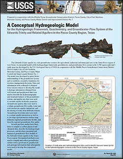
Thomas, J.V., Stanton, G.P., Bumgarner, J.R., Pearson, D.K., Teeple, A.P., Houston, N.A., Payne, J.D., and Musgrove, MaryLynn, 2013, A conceptual hydrogeologic model for the hydrogeologic framework, geochemistry, and groundwater-flow system of the Edwards-Trinity and related aquifers in the Pecos County region, Texas: U.S. Geological Survey Fact Sheet 2013–3024, 6 p., https://pubs.usgs.gov/fs/2013/3024/.


Contents

Hydrogeologic Framework

Hydrostratigraphic Layers

Geochemistry

Groundwater-Flow System

References Cited


Accessibility FOIA Privacy Policies and Notices

Take Pride in America logo USA.gov logo U.S. Department of the Interior | U.S. Geological Survey
URL: http://pubsdata.usgs.gov/pubs/fs/2013/3024/index.html
Page Contact Information: GS Pubs Web Contact
Page Last Modified: Tuesday, 29-Nov-2016 17:48:19 EST