 Abstract Abstract
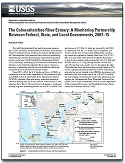
The tidal Caloosahatchee River and downstream estuaries have substantial environmental, recreational, and economic value for southwest Florida residents and visitors. Modifications to the Caloosahatchee River watershed have altered the predevelopment hydrology, thereby threatening the environmental health of estuaries in the area. Hydrologic monitoring of the freshwater contributions from tributaries to the tidal Caloosahatchee River and its estuaries is necessary to adequately describe the total freshwater inflow and constituent loads to the delicate estuarine system.
From 2007 to 2013, the U.S. Geological Survey (USGS), in cooperation with the Florida Department of Environmental Protection (FDEP) and the South Florida Water Management District (SFWMD), operated a flow and salinity monitoring network at tributaries flowing into and at key locations within the tidal Caloosahatchee River. This network was designed to supplement existing long-term monitoring stations, such as W.P. Franklin Lock, also known as S–79, which are operated by the USGS in cooperation with the U.S. Army Corps of Engineers, Lee County, and the City of Cape Coral. Additionally, a monitoring station was operated on Sanibel Island from 2010 to 2013 as part of the USGS Greater Everglades Priority Ecosystem Science initiative and in partnership with U.S. Fish and Wildlife Service (J.N. Ding Darling National Wildlife Refuge). Moving boat water-quality surveys throughout the tidal Caloosahatchee River and downstream estuaries began in 2011 and are ongoing. Information generated by these monitoring networks has proved valuable to the FDEP for developing total maximum daily load criteria, and to the SFWMD for calibrating and verifying a hydrodynamic model. The information also supports the Caloosahatchee River Watershed Protection Plan.
|
First posted December 19, 2014
Part or all of this report is presented in Portable Document Format (PDF). For best results viewing and printing PDF documents, it is recommended that you download the documents to your computer and open them with Adobe Reader. PDF documents opened from your browser may not display or print as intended. Download the latest version of Adobe Reader, free of charge. More information about viewing, downloading, and printing report files can be found here.
|

