Skip Links

USGS - science for a changing world

Fact Sheet 2015–3008

Flood-Inundation Mapping for the Blue River and Selected Tributaries in Kansas City, Missouri, and Vicinity, 2012

By David C. Heimann, Trina E. Weilert, Brian P. Kelly, and Seth E. Studley

Thumbnail of and link to report PDF (5.47 MB)Abstract

Kansas City, Missouri, has severely flooded many times, most notably in 1951, 1961, 1977, 1984, 1990, 1998, and 2010. During the past 30 years these floods resulted in damages within Kansas City costing tens of millions of dollars and more than 25 casualties.

The U.S. Geological Survey (USGS) and City of Kansas City, Missouri, operate multiple streamgages along the Blue River and tributaries in and near the city. Knowledge of water level at a streamgage is difficult to translate into depth and areal extent of flooding at points distant from the streamgage. One way to address these informational gaps is to produce a library of flood-inundation maps that are referenced to the stages recorded at a streamgage. By referring to the appropriate map, emergency responders can discern the severity of flooding (depth of water and areal extent), identify roads that are or may be flooded, and make plans for notification or evacuation of residents in harm’s way for some distance upstream and downstream from the streamgage. The USGS, in cooperation with the city of Kansas City, Missouri, developed a library of flood-inundation maps for the Blue River and selected tributaries.

First posted January 27, 2015

For additional information contact:
Director, Missouri Water Science Center
U.S. Geological Survey
1400 Independence Road
Rolla, MO 65401
http://mo.water.usgs.gov/

Part or all of this report is presented in Portable Document Format (PDF). For best results viewing and printing PDF documents, it is recommended that you download the documents to your computer and open them with Adobe Reader. PDF documents opened from your browser may not display or print as intended. Download the latest version of Adobe Reader, free of charge. More information about viewing, downloading, and printing report files can be found here.


Suggested citation:

Heimann, D.C., Weilert, T.E., Kelly, B.P., and Studley, S.E., 2015, Flood-inundation mapping for the Blue River and selected tributaries in Kansas City, Missouri, and vicinity, 2012: U.S. Geological Survey Fact Sheet 2015–3008, 4 p., https://dx.doi.org/10.3133/fs20153008.

ISSN 2327-6932 (online)
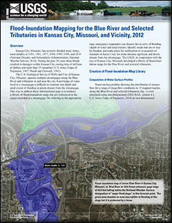


Contents

Overview

Creation of Flood-Inundation-Map Library

Development of Flood-Inundation Maps

Flood-Inundation Map Delivery

References Cited


Accessibility FOIA Privacy Policies and Notices

Take Pride in America logo USA.gov logo U.S. Department of the Interior | U.S. Geological Survey
URL: http://pubsdata.usgs.gov/pubs/fs/2015/3008/index.html
Page Contact Information: GS Pubs Web Contact
Page Last Modified: Tuesday, 29-Nov-2016 18:34:27 EST