Skip Links

USGS - science for a changing world

Fact Sheet 2015–3049

USGS Arctic Science Strategy 2015–2020

By Mark Shasby and Durelle Smith

Background

The United States is one of eight Arctic nations responsible for the stewardship of a polar region undergoing dramatic environmental, social, and economic changes. Although warming and cooling cycles have occurred over millennia in the Arctic region, the current warming trend is unlike anything recorded previously and is affecting the region faster than any other place on Earth, bringing dramatic reductions in sea ice extent, altered weather, and thawing permafrost. Implications of these changes include rapid coastal erosion threatening villages and critical infrastructure, potentially significant effects on subsistence activities and cultural resources, changes to wildlife habitat, increased greenhouse-gas emissions from thawing permafrost, threat of invasive species, and opening of the Arctic Ocean to oil and gas exploration and increased shipping. The Arctic science portfolio of the U.S. Geological Survey (USGS) and its response to climate-related changes focuses on landscape-scale ecosystem and natural resource issues and provides scientific underpinning for understanding the physical processes that shape the Arctic. The science conducted by the USGS informs the Nation’s resource management policies and improves the stewardship of the Arctic Region.

Context:

The rapid changes facing the Arctic region resulting from climate change requires reliable scientific research and up-to-date information to help policy makers make informed resource management decisions. It is imperative that the USGS establish and undertake an Arctic science strategy that is responsive to national priorities and objectives for the region.

“The United States is an Arctic Nation, where we seek to meet our national security needs, protect the environment, responsibly manage resources, account for indigenous communities, support scientific research, and strengthen international cooperation on a wide range of issues.”

National Strategy for the Arctic Region–Implementation Plan (January 2014)

Map showing Arctic

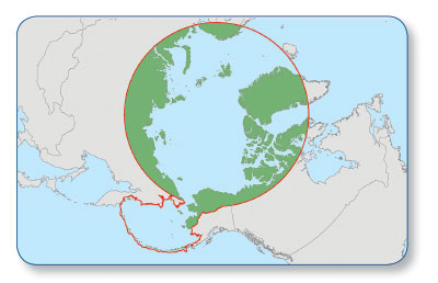
Arctic boundary as defined by the Arctic Research and Policy Act. Image Credit: U.S. Arctic Research Commission.

Focus:

USGS will provide sound and relevant scientific information that supports the goals identified in the National Strategy for the Arctic Region to pursue responsible Arctic region stewardship, strengthen international cooperation, and make decisions using the best available information.

Goals of the National Strategy for the Arctic Region (May 2013)

  • Pursue Responsible Arctic Region Stewardship: “…continue to protect the Arctic environment and conserve its resources; establish and institutionalize an integrated Arctic management framework; chart the Arctic region; and employ scientific research and traditional knowledge to increase understanding of the Arctic.”
  • Strengthen International Cooperation: “…support scientific research and strengthen international cooperation on a wide range of issues.”
  • Make Decisions Using the Best Available Information: “…across all lines of effort, decisions need to be based on the most current science and traditional knowledge.”

USGS 5-Year Arctic Science Strategy: USGS will focus its science efforts on the following goals and actions:

GoalsActions
Improve scientific information for Arctic coastal communities and ecosystems
  • Provide science that informs climate change adaptation strategies for Arctic coastal communities.
  • Conduct sea floor mapping throughout the U.S. Exclusive Economic Zone and Extended Continental Shelf of Arctic marine habitats to support environmental and energy development programs.
  • Provide shoreline vulnerability assessments and coastline projections using climate scenarios to support ecosystem sustainability, and community and industry infrastructure planning.
Advance an integrated, landscape scale understanding of Arctic ecosystems and the potential for future change
  • Quantify and forecast effects of a changing Arctic on U.S. Department of the Interior trust species and habitats.
  • Understand and project changes in marine and terrestrial ecosystems of the Arctic, including effects of invasive species and changing fire regimes.
  • Improve understanding of bio-physical parameters of significance to ecosystem outcomes and capacity to forecast future climate effects.
  • Use structured decision-making and decision-support products.
Assess mineral and energy resources present in Arctic landscapes, and evaluate environmental implications of Arctic resource development
  • Develop a full spectrum of Arctic energy resource assessments, including oil and gas, gas hydrates, coal, coalbed methane, and geothermal energy.
  • Assess mineral resources, including strategic and critical minerals.
  • Assess geo-environmental properties in conjunction with resource assessments, and use combined results in life cycle assessments to evaluate environmental implications of Arctic resource development.
Determine effects of a changing Arctic on environmental health
  • Study mercury dynamics, gas fluxes, and effects in a thawing permafrost environment.
  • Assess emerging wildlife disease and potential human health effects.
  • Conduct science for community sustainability including Alaska Native subsistence effects and water quality.
Enhance the scientific understanding of the physical processes unique to the Arctic
  • Continue to monitor baseline conditions of the cryosphere.
  • Conduct onshore and shallow marine studies of near-surface permafrost dynamics.
  • Increase our understanding of Arctic hydrology in a changing climate.
  • Assess carbon fluxes and sequestration potential.
  • Assess effects of glaciers on freshwater, riparian, and coastal ecosystems.
Improve statewide geospatial data and mapping to meet the needs of safety, planning, research, and resource management partners
  • Update digital geospatial infrastructure for Alaska for elevation, imagery, surface water, transportation, geodetic control, and boundary data statewide.
  • Produce new topographic map series for all of Alaska with improved foundational digital map layers including elevation, imagery, surface water, transportation, geodetic control, and boundaries.
  • Produce high-resolution permafrost maps.

Advisory Groups:

USGS will support emerging science needs through collaborative partnerships and initiatives by participating and providing leadership in the following:

  • Arctic, Western Alaska, Northwest Boreal, and Aleutian Bering Sea Islands Landscape Conservation Cooperatives
  • North Slope Science Initiative
  • Integrated Arctic Management Working Group
  • Arctic Council and its Working Groups
  • North Pacific Research Board
  • Alaska Mapping Executive Committee and Alaska Geospatial Council
  • Alaska Climate Change Executive Roundtable

First posted July 20, 2015

For additional information, contact:
Regional Director for Alaska
U.S. Geological Survey
4210 University Drive, Anchorage, Alaska 99508
(907) 786-7000
http://alaska.usgs.gov

Part or all of this report is presented in Portable Document Format (PDF). For best results viewing and printing PDF documents, it is recommended that you download the documents to your computer and open them with Adobe Reader. PDF documents opened from your browser may not display or print as intended. Download the latest version of Adobe Reader, free of charge. More information about viewing, downloading, and printing report files can be found here.


Suggested citation:

Shasby, Mark, and Smith, Durelle, 2015, USGS Arctic science strategy, 2015–2020: U.S. Geological Survey Fact Sheet 2015-3049, 2 p., https://dx.doi.org/10.3133/fs20153049.

ISSN 2327-6916 (print)

ISSN 2327-6932 (online)


Accessibility FOIA Privacy Policies and Notices

Take Pride in America logo USA.gov logo U.S. Department of the Interior | U.S. Geological Survey
URL: http://pubsdata.usgs.gov/pubs/fs/2015/3049/index.html
Page Contact Information: GS Pubs Web Contact
Page Last Modified: Tuesday, 29-Nov-2016 18:34:52 EST