This document is also available in pdf
format: ![]() fs-001-99.pdf
fs-001-99.pdf
For more than 100 years, the U.S. Geological Survey (USGS) has been mapping, measuring, describing, and seeking to increase the understanding of Kansas’ natural resources. The USGS is known for impartial data collection and data interpretation that enable resource planners and others to make informed decisions. Today’s issues are more pressing than ever—understanding natural hazards to minimize their effects on life and property, the continuing need for mineral- and water-resource development, and understanding the effects of human activities on biological and water resources.
As the Nation’s leading earth-science agency, the USGS cooperates with more than 30 Federal, State, and local agencies in Kansas to produce maps, interpretive reports, and data to help these agencies manage the State’s resources. Cooperators include State natural resources agencies, county and municipal public works departments, tribal governments, universities, and other Federal agencies. The USGS also provides support to the Kansas Water Resources Institute, which conducts research, education, and information and technology transfer programs at Kansas State University in Manhattan.
|
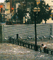
Figures 1. With floodgates closed behind him, a USGS hydrographer measures the water level of the Marais des Cygnes River from the submerged U.S. Highway 59 bridge near Ottawa, northeastern Kansas. (Photograph courtesy of Richard Gwin, Lawrence Journal-World, Lawrence, Kansas.) |
Real-time flood information, such as watches and warnings issued by the National Weather Service, depends on data collected by the USGS at 140 automated streamflow-gaging stations in Kansas. USGS streamflow data also are used throughout Kansas by many Federal, State, and local agencies, as well as by private companies and individuals. Some of these customers use the streamflow data to provide flood warnings and to manage the State’s reservoir system to reduce the loss of life and property caused by floods (fig. 1). Flood-frequency reports based on USGS streamflow information are used to design safe and economical highway bridges, culverts, and other structures; to zone and regulate activity in flood plains, thereby saving lives and reducing property damage; and to set flood-insurance rates.
|
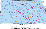
Figures 2. Location of streamflow-gaging stations in Kansas. |
Demand for water in Kansas sometimes is greater than the available supply. The USGS provides critical information about the availability of water supplies to State agencies that are responsible for water-resources management, such as the Kansas Department of Agriculture’s Division of Water Resources (DWR) and the Kansas Water Office (KWO), and to local water suppliers such as the city of Wichita. In cooperation with 14 Federal, State, and local agencies, the USGS established and operates a near-real-time data-collection network of more than 180 streamflow-gaging stations. This network (fig. 2) provides information necessary to quantify the amount of water available for various uses; the network is updated continually to reflect changing information needs. Near-real time streamflow information for selected stations is available on the World Wide Web at http://ks.water.usgs.gov
In cooperation with the DWR and the KWO, the USGS also has developed databases used for estimating water use and ground-water recharge. These help water-management officials minimize overdevelopment of water resources and prevent the infringement of water rights. The data collected by the USGS also are important for addressing interstate conflicts over water in rivers that cross State boundaries.
The USGS has assisted the city of Wichita in assessing the potential for innovative solutions to meet future water-supply needs. The USGS is documenting ground-water-level changes in the Equus Beds aquifer in south-central Kansas, one of two water-supply sources for the city. The USGS is evaluating the water-quality effects of the city’s aquifer-recharge demonstration project. These efforts are intended to provide vital information for Wichita to manage its water-supply sources. This information also may be useful nationally for other aquifer-recharge projects.
The USGS also has evaluated the water-supply potential and effects of pumping at the cities of Manhattan and Junction City in northeastern Kansas. This information helps water managers balance supply and demand so that the citizens of Kansas can prepare for future water-supply problems before they become crises.
Parts of Kansas have undergone substantial urbanization during the past several decades. This has led to deterioration in surface- and ground-water quality in some areas. The USGS has filled an important role in assessing the effects of urbanization on stormwater runoff and surface-water quality and by determining the effects of landfills on ground-water quality. This information can be used by municipal planners and others to manage the effects of present and future urban development.
Modern agricultural practices rely on pesticides and fertilizers to increase crop yields. Excessive levels of some of these chemicals may be harmful to humans and aquatic life and have been detected in rivers and reservoirs used as public drinking-water supplies.
The USGS provides water-resources information to several State agencies, such as the Kansas Department of Agriculture, and municipal water suppliers to help them define and manage this problem. The USGS has collected surface-water samples to determine concentrations of pesticides in the northeastern and south-central parts of the State. USGS streamflow measurements also are important for computing chemical loads, and the results contribute to understanding the sources and movement of pesticides and nutrients in water.
In 1993–94, the USGS monitored pesticide concentrations in the Delaware River Basin and downstream from Perry Lake in northeastern Kansas to determine pesticide loads and concentrations in the streams and the lake. Findings indicate that more than one-half of the annual contributions of the herbicide atrazine to Perry Lake occur within 10 days of the year and that climatic and hydrologic variations frequently had a greater effect on annual loads than did changes in land-management practices. These findings are important for designing effective monitoring programs and management strategies in Kansas and nationwide.
The USGS also has conducted extensive water-quality monitoring in the Cheney Reservoir watershed in south-central Kansas. This monitoring has identified the chemical constituents of greatest concern, documented the effects of best-management practices, and has been used to target the implementation of best-management practices.
The Quivira Wildlife Refuge in south-central Kansas has been receiving reduced inflows from Rattlesnake Creek as a result of over-appropriation upstream. The USGS developed a flow-routing model and system to enable refuge managers to efficiently allocate water within the refuge and to help mitigate the effects of reduced streamflow.
The reservoir system has been a great benefit to the citizens of Kansas, especially for water supply, recreation, and flood control. Streamflow-data analysis by the USGS provided an independent verification of the benefits of the Kansas River Basin reservoir system in northeastern Kansas during the 1993 floods.
The accumulation of sediment of degraded quality is a concern in Kansas reservoirs. The USGS has conducted sediment-quality studies on six reservoirs in Kansas. A sediment study of Hillsdale Lake in northeastern Kansas determined that more than 90 percent of the phosphorus, a critical nutrient in lake eutrophication, came from runoff from farms and subdivisions in the watershed and less than 10 percent came from waste-treatment plants—a key finding in developing regulatory and management strategies. USGS scientists are studying the reservoirs on the Solomon and Republican Rivers to evaluate the effects of irrigation practices on the transport of selenium.
The USGS has been cooperating with the Natural Resources Conservation Service (NRCS), the Farm Service Agency, and the Kansas Water Office to produce digital orthophotoquads (DOQ’s) for the State. DOQ’s are scanned aerial photographs in which the distortions and displacements caused by camera orientation and terrain are removed. A DOQ may be loaded into a geographic information system (GIS) and used with other data for analysis and geographic applications. The NRCS has been using DOQ’s as a base to digitize soils throughout the State. Other applications of DOQ’s include collecting and updating land use and land cover, natural-resource mapping, and timber management and monitoring. The DOQ series for Kansas is almost complete.
Statewide Hydrography Project
The USGS is cooperating with the NRCS to produce 1:24,000-scale hydrography digital line graphs for Kansas. The hydrography will be compiled and revised by the NRCS using DOQ’s as the source and digital hydrography data previously created by the Kansas Geological Survey as a background reference. All of the stream networks and water features will be made into digital X-Y coordinate data during a 3-year period. The hydrography is being compiled in conjunction with the digitizing of riparian vegetation for the Kansas Water Office. Eventually, DLG data will be converted to a computer model and become part of the National Hydrography Dataset (NHD). The NRCS, the Kansas Water Office, and other State agencies may use the 1:24,000-scale NHD for hydrologic modeling and pollution and hazards monitoring.
National Aerial Photography Program
Black-and-white aerial photography over Kansas was completed in the spring of 1996 as part of the National Aerial Photography Program (NAPP). Administered by the USGS, the NAPP is supported by several Federal agencies and the States. Although Kansas has been completely photographed, about 15 percent will be rephotographed in spring 1999. NAPP photographs can be used as a management tool for monitoring land-use and land-cover changes, timber and natural-resource management, and for soil and field delineation. Aerial photographs may be acquired from the USGS EROS Data Center in Sioux Falls, S. Dak.
Topographic County Mapping Partnership
The USGS continues its partnership begun in 1980 with the Kansas Geological Survey to produce 1:100,000-scale topographic county maps for the State. The county-based topographic maps support management and research activities in the State. Approximately 12 counties remain to be mapped to complete statewide coverage. Completed maps may be obtained from the Kansas Geological Survey in Lawrence.
The National Cooperative Geologic Mapping Program creates geologic maps and digital geologic data bases to solve resource, land-use, hazard, and environmental problems and to develop GIS-based methods for assessing risks, for reducing economic losses from natural hazards, and for making optimal land-use decisions, while building a digital geologic-map data base for the Nation to help guide public policy. These program objectives are accomplished cooperatively with State geological surveys, universities, and Federal agencies. The Kansas Geological Survey is continuing the geologic mapping (at a scale of 1:24,000) of Comanche, Bourbon, Hamilton, and Kearny Counties under the auspices of the STATEMAP Program, which supports geologic mapping in 40 or more States annually.
The Gap Analysis Program (GAP) is a national program that is conducted as State-level projects and is coordinated by the USGS. It is a collaborative effort among private groups, regional, State, and Federal agencies to provide regional assessments of the conservation status of native wildlife and natural land-cover types and to facilitate use of this information in land management. The GAP maintains information in a computer-based GIS that shows land cover, land ownership, land management, and wildlife distribution. The Kansas GAP began in May 1995, and it is expected to be completed in September 2000. Cooperators include the USGS, the University of Kansas, and Kansas State University. Land-cover mapping is in its final stages, and distribution models of 350 species of Kansas wildlife are being developed. Major partners who expect to use the Kansas GAP information are the Kansas Department of Wildlife and Parks, the Kansas Water Office, the U.S. Fish and Wildlife Service, the U.S. Forest Service, the U.S. Environmental Protection Agency (EPA), and the NRCS.
|
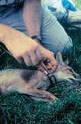
Figures 3. Tranquilized swift fox being fitted with a radio collar. |
The diminutive swift fox (fig. 3) once occupied most of the Great Plains from west-central Texas to the Canadian prairies. Settlement of the prairie led to rapid decreases in swift fox numbers. Currently, populations live in Colorado, Kansas, Wyoming, Montana, New Mexico, Oklahoma, and Texas. Although the swift fox is moderately abundant in Kansas, it is absent from parts of its historic range within the State. The USGS and the Kansas Department of Wildlife and Parks are developing information needed to improve management of swift fox in Kansas and elsewhere. The USGS is leading the development of reliable monitoring methods and is gathering information about swift fox biology and population for the U.S. Fish and Wildlife Service. Two populations of swift foxes in western Kansas have been studied using telemetry techniques. Also, the USGS is evaluating competition between swift fox and red fox, which may inhibit establishment of swift foxes in areas occupied by red foxes. This information is intended to aid managers’ attempts to relocate swift foxes elsewhere in the State to enhance their conservation.
|
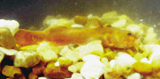
Figures 4. Neosho madtom. |
The Neosho madtom (Noturus placidus) (fig. 4), Federally listed as a threatened species, is a small catfish found in the Midwest. Cherokee County in southeastern Kansas supports one of the remaining Neosho madtom populations, but the area is affected by severe water-quality and habitat degradation. Once a lead-zinc mining region, the tri-state area of Kansas, Oklahoma, and Missouri now has several EPA Superfund sites and is on the agency’s National Priority List for remediation. The USGS is studying the biological effects of mining wastewaters on the Neosho madtom populations in the Neosho and Spring Rivers of Kansas. Water and sediment are toxic at sites within the range of the Neosho madtom in the Spring River, and zinc concentrations are high enough to be a factor limiting the distribution and abundance of the species. This information is important to the restoration efforts by the U.S. Fish and Wildlife Service and Kansas natural-resource managers, to removing this species from the list of threatened species, and to creating viable fisheries in these degraded river systems.
|
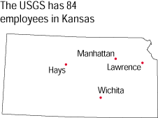
The office locations
|
USGS State Representative USGS Home Page Reports
and products |