This document is also available in pdf format:
![]() fs-004-99.pdf
fs-004-99.pdf
Some organisms in the lower Colorado River have attained or are approaching levels of selenium accumulation that are known to cause reproductive abnormalities. USGS researchers at the Arizona Cooperative Fish and Wildlife Research Unit are studying the pathways and impacts of selenium accumulation. Selenium originates from shales in the upper Colorado River Basin, not from irrigation return flow, as is often assumed.
Studies have shown that selenium levels are elevated in the tissues of clams, freshwater shrimp, aquatic insects, crayfish, fish, fish-eating birds, and other birds that live along the river. Selenium levels generally are highest in organisms living in backwater lakes along the lower Colorado River that have restricted circulation but that are open to the river. Studies have revealed, however, that increasing water flow from these backwater lakes does not lower selenium levels in the lakes’ aquatic inhabitants. The USGS is working with other agencies to evaluate selenium levels in wetlands near the mouth of the Colorado River in Mexico.
By combining agriculture and aqua-culture, farmers can produce two crops using the same water, thereby reducing water costs and increasing farm revenues by as much as 7 per-cent. Wastewater from an aquaculture operation can be used to irrigate crops, thus eliminating the cost of effluent treatment or disposal and providing crops with an additional source of nitrogen.
 |
|
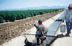
Figure 1. USGS biologists sample fish raised in irrigation ditches. |
Aquaculture and agriculture are more efficiently integrated when fish are raised in preexisting irrigation structures using no more water than is required to support crop growth. USGS researchers at the Arizona Cooperative Fish and Wildlife Research Unit have cultured fish in irrigation ditches where water is allowed to flow through the fishculture area only when crops are being irrigated (fig. 1). Developing countries have shown great interest in these "Pulsed Flow Culture Systems" because of the potential for reducing water use and increasing revenues.
USGS geologists, in cooperation with the National Park Service, are creating geologic maps and interpretive materials for selected national parks.
In the Lake Mead National Recreation Area in northwestern Arizona, geologists are reconstructing the long and complex geologic story of the region over the last 1.8 billion years. In Grand Canyon National Park, geologists are creating maps of the entire Grand Canyon, within the park and outside park boundaries. Details of both projects can be seen on the Web at http://wrgis.wr.usgs.gov:80/docs/wgmt/nationalparks/NatParks.html
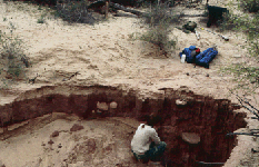
Also in Grand Canyon National Park, geologists are identifying archeological sites in danger of destruction, establishing a time scale of predam erosion and deposition, and interpreting long-term patterns of sediment input from the Paria and Little Colorado Rivers. A recently developed model of near-channel erosion will help geologists determine the effects of streamflow on cultural resources along the Colorado River.
 |
 |
|
|
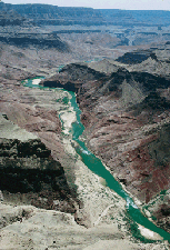
Figure 2. The Grand Canyon region is the focus of geologic mapping. |
Figure 3. Artifacts in the Grand Canyon may be susceptible to erosion in small drainages along the river. |
USGS geologists are combining new and existing geologic data and imagery to create three-dimensional views and models of the upper Santa Cruz and San Pedro River Basins of southeastern Arizona and northern Sonora, Mexico. This study emphasizes gaining a better understanding of the baseline condition, aquifer systems, and distribution of metals in these areas. The goal of this research is to provide objective data to use in resolving land-use issues about mineral and water resources.
 |
|
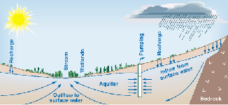
Figure 4. Water moves underground from mountains to streams in many areas of the Southwest. Pumping of ground water can deplete the supply of water to streams. |
In the Southwest, most replenishment, or recharge, of ground water takes place at high elevations along the margins of many aquifers. Water moves underground through these aquifers until it comes to the surface in discharge areas at streams, springs, lakes, and wetlands. Ground-water pumping between recharge and discharge areas may ultimately reduce water flow to the discharge areas, which may, in turn, bring about changes to the community of organisms that inhabit these areas.
In 1998, USGS hydrologists began studying the interactions of ground water and surface water in the southwestern United States. Management of areas near rivers that depend on ground water is important to the management of urban and agricultural water supplies because of potential threats to endangered species and to the health of these natural systems. In this study, hydrologists are assessing the impacts of climate variation and ground-water development on ground-water systems and riverdependent biological communities. Hydrologists also plan to develop improved methods to quantify ground-water recharge and assess the potential effects of future climate changes and development on groundwater systems in parts of California, Nevada, Utah, Arizona, and New Mexico. Information gained from this study is intended to help scientists assess the availability and sustainability of ground-water resources in the rapidly growing southwestern United States. Much of the work is being done in cooperation with State and local agencies in the study area.
Several new tools are helping USGS hydrologists gather information on ground-water recharge, sediment erosion, and streamflow.
 |
|
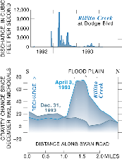
Figure 5. >Gravitational pull measured along Swan Road near Tucson increased in response to ground-water recharge from floods in Rillito Creek in 1992-93. |
In the Tucson area, hydrologists are using an instrument capable of measuring Earth’s gravitational pull very precisely to measure directly the amount of ground-water recharge in near-surface aquifers following floods like those that occurred in 1992–93. Gravitational pull increases as sediment in an aquifer becomes saturated with water. This method was developed in cooperation with the Arizona Department of Water Resources, Metropolitan Domestic Water Improvement District, City of Tucson, Town of Oro Valley, and Pima County.
New sensors developed in Tucson are being used to measure erosion and deposition of sediment. Each sensor contains a liquid cell that weighs the sediment and the water lying above it and a pore-pressure device that weighs the water alone. The difference between the two measurements is the weight of sediment above the sensor. Sensors buried in a sandbar along the Colorado River in the Grand Canyon made it possible for hydrologists to document deposition and erosion during an experimental, human-induced flood in 1996. Information about the amount of sand stored in the canyon and how sand moves in response to releases from Glen Canyon Dam is important to agencies that manage the resources of the Colorado River, including the Bureau of Reclamation, the Western Area Power Administration, the U.S. Fish and Wildlife Service, and the National Park Service.
Stream-monitoring technology took a step forward with the installation in 1998 of a camera at a USGS streamflow-gaging station on the Verde River near Scottsdale. The station is maintained in cooperation with the Salt River Project. During the day, an image captured by the camera is transferred hourly by cellular phone to the USGS office, where it is displayed on the Web at http://az.water.usgs.gov/
USGS planetary geologists are working with the National Aeronautics and Space Administration (NASA) to provide direct support to planetary spaceflight missions. The geologists participate in instrument design and development, mission design and planning operations, and data analysis. Using their skills in image processing and planetary mapping, USGS geologists also produce materials used by the international space science and education communities.
 |
|
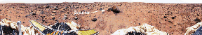
Figure 6. Mars Pathfinder provided panoramic views of the Martian landsape. In this view, look for the rover "Sojourner" nestled aganist a large rock named "Yogi." |
The USGS has members on the flight team that is supporting the Mars Global Surveyor Mission, currently orbiting Mars. The goal of the mission is to provide global maps of Martian surface topography and mineral distribution and to monitor Martian weather over a 2-year period. Information gathered will significantly enhance our understanding of Mars and also may provide insights into Earth’s past.
The USGS is participating in the NASA Cassini Mission to place a spacecraft in orbit around Saturn and a probe on Titan—one of Saturn’s moons—in 2003. The Cassini spacecraft will orbit Saturn for 4 years and will send back information about the planet’s moons, rings, and magnetic environment. Titan is particularly interesting to scientists because its surface and atmosphere may contain hydrocarbons from which life is thought to have begun on Earth. (Life is not expected to exist on Titan, because temperatures are about –360 F.)
Deep-Space 1, a solar-electron/ion-propulsion spacecraft, will soon embark on a mission to investigate comets and asteroids at the far reaches of the solar system. USGS scientists are involved in the flight of this spacecraft and are part of the team responsible for designing and producing specialized instruments, which include a miniature camera, that Deep-Space 1 will carry.
Information on the USGS’s planetary and terrestrial programs in northern Arizona can be seen on the Web at http://wwwflag.wr.usgs.gov
USGS cartographers have completed a set of 1,956 digital maps of the entire State of Arizona using Digital Raster Graphics (DRG’s) developed from topographic maps (at a scale of 1:24,000). These maps depict natural and human-made features, which include lakes, streams, highways, railroads, and boundaries, as well as geographic names. Contour lines show elevation and shape of the terrain. These maps are useful for civil engineering, land-use planning, natural-resource monitoring, and other technical and scientific applications.
Another set of maps, based on Digital Elevation Models (DEM’s), also have been completed for Arizona. DEM’s depict topographic relief. Maps created from DEM’s show three-dimensional perspectives of the landscape, help researchers to assess slope and aspect when mapping vegetation and habitats, are used with hydrologic computer models for flood analysis, and are used for planning hazard mitigation.
USGS cartographers are producing another digital product—Digital Orthophoto Quadrangles (DOQ’s)—in cooperation with the USDA-Natural Resources Conservation Service and the Farm Service Agency. DOQ’s are scanned aerial photographs in which distortion and displacement caused by camera orientation and terrain have been digitally removed. These very accurate aerial images then can be put into a geographic information system and used with other data for analyses. DOQ’s provide information about soils, land use, and land cover, and are useful as base maps for natural- resource inventories and mapping, field-boundary delineation, and other geoscience applications.
The USGS uses sonar-, satellite-, and airborne-image data to identify and monitor environmental problems on the land and in coastal and interior waterways. Satellite imagery and DEM’s are being used to evaluate ground-water resources in the Flagstaff area and to map wind erosion in the southwestern United States. The results of these and other projects can be seen on the Web at http://terraweb.wr.usgs.gov/TRS
 |
|
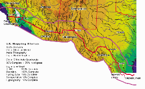
Figure 7. United States-Mexico transboundary mapping. |
USGS cartographers are working with agencies and organizations in the United States and Mexico to create DOQ’s for a 100-mile zone on each side of the border. DRG’s already have been developed from 1:24,000-scale topographic maps of the four States on the United States side of the border—Texas, New Mexico, Arizona, and California. Furthermore, in cooperation with the University of Arizona, USGS geologists are working on a digital transboundary geologic map and database. The area involved in this project consists of a band about 155 miles wide along the entire 2,000-mile border between the United States and Mexico. The database is intended to be used by scientists and managers in joint United States/Mexican activities that involve air pollution, natural resources, urban development, watershed analysis, environmental health, emergency response, and shared water resources. Additional information about the mapping project can be found at the United States-Mexico Border Field Coordinating Committee’s Web page at http://www.doi.gov/fcc
|
USGS office locations
|
USGS State Representative Reports and products |