This document is also available in pdf format:![]() fs-007-99.pdf
fs-007-99.pdf
Many abandoned or inactive mines are on or adjacent to public lands. Wastes from many of these abandoned mine lands affect resources on public lands. In 1995, a Federal interdepartmental strategy was developed to address remediation of affected areas on public lands. The strategy uses a watershed approach, and is focused on developing methods to understand the processes that release and transport acid and metals to streams and the subsequent response of biologic communities. The U.S. Geological Survey (USGS) is working closely with the Federal land-management agencies, State agencies, and local watershed groups to develop efficient and cost-effective methods to evaluate effects and formulate plans for remediation.
The USGS is studying the upper Animas River basin in southwestern Colorado to identify metals and other substances in water from these abandoned mine lands. Scientists are determining the toxicity of metals and studying their movement through food webs, which will help determine the effects of mining waste on critical high-altitude habitats. Preliminary results show that water becomes acidic when surface water reacts with altered rock surrounding mineral deposits and waste rock from mining activities. Metals from stream waters attach to sediments and are deposited on the streambed, which affects aquatic habitat and the food chain.
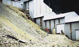
| Figure 1. Collecting samples from a mine waste dump. |
The USGS Mine Waste Characterization Project is an interdisciplinary research project to develop methods for characterizing weathered, solid mine waste (fig. 1). Potential metal release and acid production from the waste depend on the mineralogical, chemical, and physical characteristics of the mine waste as well as geo-chemical and microbial processes.
Scientists from numerous disciplines are working together in Silverton and Leadville to evaluate characterization methods and to understand processes in solid mine-waste systems. The Bureau of Reclamation and the U.S. Environmental Protection Agency (EPA) have asked the USGS to develop rapid, cost-effective methods for locating potential sources of acidic mine drainage so that they might expedite and streamline the remediation process.
The USGS, in cooperation with local, State, and Federal agencies, is conducting studies to characterize soil and water contamination caused by the past production, storage, or destruction of chemical agents, munitions, radioactive materials, fuels, and solvents. The studies characterize the hydrology of the sites, define the extent of contamination, evaluate monitoring networks, determine contaminant transport mechanisms, and model the fate of contamination. The USGS is assessing the potential of zero-valence iron for passive remediation of contaminants in ground water at several sites that have different hydrogeologic settings and contaminants.
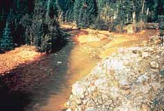
| Figure 2. Contaminated stream. |
Contamination from nonpoint sources such as agriculture, mining, and urban land uses can degrade the quality of water for drinking, irrigation, and recreational use and can affect the biota of streams, lakes, and wetlands (fig. 2). Population growth and residential development in the mountains have increased demands on ground-water supplies, increased septic-system effluent returning to the ground-water system, and heightened public concern about the adequacy and quality of ground water. USGS scientists are evaluating nitrate contamination in soil and ground water from confined, animal-feeding operations, assessing the effectiveness of bioremediation to reduce nitrate concentrations in ground water, and assessing the effects on ground water and soil of treated-sewage-sludge applications.
Rehabilitation of existing infrastructure and development of new infrastructure to support human populations require the use of natural resources, including natural aggregate (stone, sand, and gravel) and water, and energy resources. Urban expansion often hinders acquisition and use of these essential raw materials by making them less accessible or by affecting their quality. Competing land uses and mandates by Federal, State, and local governments preclude obtaining or using these resources in some areas. The goal of the USGS Front Range Infrastructure Resources Project is to provide decision makers and the public with objective information about the location and characteristics of land, natural aggregate, water, energy resources, and biological resources and their relations to the development of infrastructure resources.
A regional inventory of resources is planned to define the basic physical resource limitations and quality of available resources and to relate resource extraction to potential effects on the environment. Streamside habitats and their potential to support diverse groups of mammals, birds, reptiles, and amphibians are being classified. Methods for restoring streamside habitats and for controlling undesirable exotic species are being examined. Newly developed data and data on natural aggregate previously compiled by the Colorado Geological Survey are integrated in geographic information systems for use by State and local agencies and the producers and users of infrastructure resources. Interaction with these groups ensures a focus on the highest priority issues and the relevance of project products.
Alpine and subalpine ecosystems on the Front Range of Colorado are among the most sensitive in North America to atmospheric deposition of nitrogen. Emissions of nitrogen compounds to the air are likely to increase because of population growth, agricultural activity, and energy development in the region. Collaborative research by the USGS, other Federal agencies, and universities is examining nitrogen-cycling processes that control retention and release of nitrogen in sensitive terrestrial and aquatic ecosystems. These findings are used to assess the current status and predict changes in ecosystem function that may result from changes in emissions or climate. Policymakers and regulators use this information to make decisions on permits for new sources and cleanup of existing sources of nitrogen emissions.
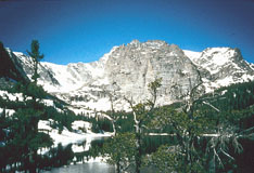
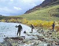
| Figure 3. High-altitude lake where fish may be affected by whirling disease. |
Whirling disease has been implicated in declines of wild trout populations in five major rivers in Colorado. The disease is caused by a parasite introduced from Europe that destroys the cartilage in the bodies of young trout, which causes them to become deformed, to swim erratically, and, eventually, to die from predation or starvation. To understand this disease and its potential management, USGS scientists at the Colorado Cooperative Fish and Wildlife Research Unit are working closely with the Colorado Division of Wildlife to develop management options to deal with the disease. The potential link between management actions and the distribution and spread of whirling disease is being examined. High-altitude lakes stocked with fish suspected of having the disease are being tested to determine if the disease can spread to wild fish in these unique, pristine waters (fig. 3). In another study, degraded habitats are being examined to determine how human influence on watersheds contributes to the spread of the parasite. The role of a head-water reservoir and a fish hatchery in the persistence of the disease also is being examined.
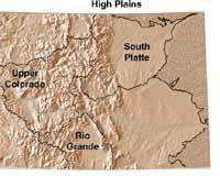
| Figure 4. National Water-Quality Assessment Study Units in Colorado. |
The National Water-Quality Assessment (NAWQA) Program is designed to describe the status and trends of the quality of the Nation'water resources and to improve information about the natural and human factors that affect water quality. The building blocks of the national NAWQA program are more than 50 Study Units. All or part of four Study Units are within Colorado (fig. 4). The South Platte River and the Rio Grande studies began in 1991, and the Upper Colorado River study began in 1994. Part of the High Plains Regional Ground-Water study, which began in 1998, is in Colorado. Information exchange and coordination through multiagency Study-Unit liaison committees ensure that the water-quality information produced by the Program is relevant to regional, local, and national interests.
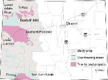
| Figure 5. Detailed coal analysis. |
The USGS National Coal Resource Assessment, conducted in cooperation with the Colorado Geological Survey and the Bureau of Land Management, provides information on the distribution and quality of coal in the Colorado Plateau. Unlike previous assessments, the geologic and geographic data are in digital format that can be updated easily with new information. The geology, coal quality, resources, and mining history are being summarized for 11 major coal units. A coal-quality database is available for selected coal fields. Five priority areas will have detailed stratigraphic analysis of coal and coal quality, a resource estimate, a stratigraphic database, and digital maps in a geographic information system. Sites were selected on the basis of areas where significant mineral ownership is federally administered, areas that have active coal mining, areas that have coalbed methane production, and areas that have high resource potential (fig. 5).
The USGS National Oil and Gas Assessment Project assesses the natural gas resources of the United States. Eighteen priority provinces, including the Uinta-Piceance (partly in Colorado), are estimated to contain 90-95 percent of the known and suspected natural gas resources of the United States. The petroleum systems and geologic assessment units in the Uinta-Piceance basin will be defined, and the suspected natural gas resources, including conventional and continuous resources, will be assessed.
Water demands associated with the rapid population growth in Colorado in recent years emphasize the need for current, reliable information on water quantity, water quality, and water use. This information can be used to improve land-use and water-management practices, to protect existing resources, and to identify and address current and future water-quantity and -quality concerns. To that end, the USGS, in cooperation with several counties, will determine the current quantity and quality of surface and ground water within those counties.
Changes in land and water use in the Arkansas River Valley have caused concerns about ground water that are being addressed by local, State, and Federal agencies. As part of this effort, the USGS is determining the areal extent of high ground-water levels that are damaging structures and crops in some parts of the valley. The USGS also is evaluating whether or not septic systems are affecting the quality of shallow ground water.
In the Rio Grande basin, the State of Colorado has identified the need for a Decision Support System to improve understanding and management of water resources in the basin. The Rio Grande Decision Support System is being developed with the assistance of an advisory committee composed of numerous public and private entities, including the USGS.
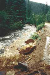
| Figure 6. Flooding and erosion in a mountain valley. |
In mountain valleys along U.S. Interstate 70, and in the hills and mountains above valley floors, geologic hazards include landslides, debris flows, erosion, unstable bedrock and surficial deposits, and flooding (fig. 6). The geology of 18 quadrangles along a segment of Interstate 70 is being mapped by the USGS. This mapping and the cooperative mapping by the Colorado Geological Survey provide the public with information on geologic hazards that is intended to facilitate informed land-use decisions and decrease conflict between development and these natural hazards.
Channel reconfiguration to mitigate riverine problems has become an important issue in the Western United States. Reasons cited for channel reconfiguration include restoration to more natural or historical conditions, improved water conveyance in flood-prone areas, mitigation of unstable reaches, increased sediment transport, and enhancement of streamside habitat. Reconfiguration of stream and river channels by using designs based on different approaches has been undertaken at numerous locations in Colorado. However, few assessments have been done of channel response to these modifications over time. The USGS is monitoring and assessing selected river reaches that have undergone such reconfigurations to assess the effectiveness of these modifications over time and to evaluate the downstream effects of channel modifications.
| Figure 7. Scientists measure ultraviolet radiation in the aquatic habitat of amphibians. |
Amphibian populations in the intermountain regions of the Western United States, including Colorado, are declining or disappearing in areas where they formerly were abundant. Solar ultraviolet (UV) radiation from ozone depletion may be causing this decline because populations are declining in relatively pristine mountainous areas. To understand why the populations are declining, USGS scientists are measuring UV radiation in the aquatic habitats of these amphibians (fig. 7). Laboratory studies are using a unique solar simulator to determine the sensitivity and effects of UV radiation on early lifestage amphibians. Recent findings indicate that increases in habitat water clarity will significantly increase UV exposure. Some amphibians, such as the endangered boreal toad, can tolerate the upper UV range currently measured in their habitats. Other amphibians, however, such as the tiger salamander or the Pacific tree frog, are at their limits of tolerance to UV and show delayed development and symptoms of immune suppression from exposure. Laboratory studies indicate that the interaction of UV and environmental contaminants is a significant hazard to amphibians. The toxicity of a common pesticide, carbaryl, increased twelvefold to gray tree-frog tadpoles in the presence of low UV radiation, and a distilled petroleum product was four times more toxic to southern leopard-frog tadpoles in the presence of UV radiation. Contaminants and UV can interact in a range of amphibian intermountain habitats, including nutrient-rich and turbid sites, and could be a critical factor in the loss of amphibians.
The National Hydrography Dataset (NHD) is a newly compiled geographic information systems database that has been developed from the EPA River Reach files and the USGS Digital Line Graph (DLG) hydrography files. The objective of developing the NHD is to provide a comprehensive, nationally accurate, high-resolution, geographic digital dataset at 1:100,000 scale. The NHD will be distributed to the public, and it can be used for computer modeling, analysis, and mapping applications. The Colorado National Hydrography Dataset Densification Project is a new innovative partnership between the USGS and the Colorado Division of Wildlife. The objective of this project is to collect and incorporate into the NHD finer resolution data (1:24,000 scale) from nearly 1,500 DLG hydrography files, thereby improving the spatial accuracy of the NHD dataset.
|
USGS office locations
|
USGS State Representative USGS Home Page: Reports and products: |