This document is also available in pdf format:
![]() fs-010-99.pdf
fs-010-99.pdf
The U.S. Geological Survey (USGS) is involved in water-related, geologic, biological, land use, and mapping studies that contribute to the safety, health, and economic well-being of Florida's citizens. The USGS State representative in the Tallahassee office acts as the liaison for all studies conducted by USGS scientists in Florida. Water resources activities are coordinated in Tallahassee, Miami, Tampa, and Orlando. Scientists in these offices investigate surface water, ground water and water quality in Florida, working in cooperation with tribes as well as other Federal, State and local agencies and organizations.
The USGS Center for Coastal Geology and Regional Marine Studies was established in St. Petersburg (see location map on back) in 1988, in cooperation with the University of South Florida. The Center conducts studies on mineral resources and on coastal and regional marine problems, including coastal erosion, climate change, wetland deterioration, and coastal pollution. A USGS mapping office is located in St. Petersburg. Also, the Earth Science Information Center in Tallahassee provides USGS information and directs inquiries to the appropriate USGS or State agency on earth science topics such as cartography, geography, aerial photography, and digital data. Biologists at the USGS Florida Caribbean Science Center, located in Gainesville, conduct biological and ecosystem studies in Florida, Puerto Rico, and the Virgin Islands.
| Figure 1. Study areas of the Suwannee River Basin Studies, the Georgia-Florida Coastal Plain NAWQA Program, the South Florida NAWQA Program, and the South Florida Ecosystem Program. |
Development of south Florida, including more than 1,400 miles of canals and 100 water-control structures, has contributed to a number of environmental problems. These problems include loss of soil, nutrient enrichment, contamination by pesticides, mercury accumulation in the biota, fragmentation of landscape, loss of wetlands and wetland functions, widespread invasion by exotic species, increasingly frequent algal blooms in coastal waters, seagrass die off, and declines in commercial and recreational fisheries. Federal and State agencies and environmental groups have proposed that south Florida and the Everglades be restored, to the extent possible, to hydrologic patterns similar to those of the predevelopment system. A Federal Task Force, chaired by the Department of the Interior (DOI), was formed in 1993 to oversee restoration. The USGS, the science agency of DOI, carries out many of the scientific activities needed to support restoration through the place-based studies program, funding a diverse group of projects in south Florida (fig. 1). Research is well underway, and in some cases is nearing completion. Major tasks of the program are:
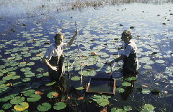
| Figure 2. USGS hydrologists sampling plants in the Everglades. |
The ground- and surface-water resources of the lower Suwannee River basin provide a variety of important benefits to north-central Florida. Although these resources have not been highly developed, demands are likely to increase from users within the basin, from within the Suwannee River Water Management District (SRWMD), and possibly from more populous areas of Florida. The SRWMD entered into a cooperative program with the USGS to study factors affecting water resources in the basin (fig.1). USGS hydrologists are developing computer-based models to simulate the karst-related, complex ground- and surface-water interactions in the basin. Environmental isotopes and age dating techniques are being used to determine the sources and chronology of nitrate contamination of springs in the basin. Also, the relation between sources of nitrate in spring waters and changes in land-use patterns over the past 50 years are being studied. In cooperation with the U.S. Fish and Wildlife Service, the USGS is determining the effects that altering a Suwannee River sill will have on river flow and water-quality regimes, and on ground water near the sill.
A study to determine the relation between wetland habitats and river flow characteristics involves field work to identify vegetation and soil types in the floodplain, determine land-surface altitudes, and monitor hydrologic conditions. Analyses and interpretations using map coverages on a geographic information system (GIS), calculations to determine habitat areas, and analyses of long-term ground-water and surface-water records are also being conducted.
More than 1,000 new chemicals are released into the environment each year, resulting in a growing potential for health risks. Increasing evidence suggests that exposure to some of these chemicals, called endocrine disrupters, can adversely affect the immune, reproductive, and endocrine systems of wildlife by interfering with natural hormones. The USGS is investigating the effects that these chemicals may have on wildlife species. Because waterways are the ultimate recipients of agricultural and industrial contaminants, aquatic animals often serve as sentinels or early indicators of environmental stress. Field and laboratory studies are underway to examine the effects of herbicides, papermill effluent, and sublethal doses of mercury on largemouth bass. Results of these studies suggest that a variety of structurally diverse pollutants can alter sex steroid hormone levels, which could lead to reproductive impairment and population declines. USGS scientists are exploring environmental factors related to massive juvenile alligator mortality in Lake Apopka, and the effect of contaminants on various mussel species in their early stages of development. Findings suggest that mussels in early stages of development, or offspring of exposed females, may be particularly sensitive to the toxic effects of certain contaminants. USGS work will be expanded to learn more about the mechanisms of hormone actions and clarify the direct and multigenerational effects of contaminant exposure.
The USGS has conducted a series of geophysical surveys on the marine shelf, covering about one-half of the Florida Keys National Marine Sanctuary. Information from the survey is being used to map the geology of the Keys, reef track, and shelf margin during approximately the last 10,000 years. Florida Keys reef growth began approximately 6,000 years ago, when rising sea levels flooded the high-and-dry south Florida platform. Florida's corals grow fast enough to have kept pace with the known rate of sea-level rise during the past 6,000 years; however, less than 1 percent of the reefs actually did keep pace, implying periodic coral deaths.
Carbon-14 age-dating methods are being used to determine the major periods of reef demise and regrowth, which may lead to finding a cause of the coral deaths. The USGS, in conjunction with the University of South Florida, will study African dust to determine its possible role in the periodic death of corals and coral reef organisms. Coral mortality became apparent in the 1970's and is increasing at alarming rates. This marked increase in coral deaths appears to parallel the well-documented rise in desertification in Africa (beginning in the 1970's) and aerosol transport across the Atlantic Ocean. African dust contains xeno-biotics, such as spores and bacteria, that have likely contributed to coral reef mortalities throughout the Caribbean basin.
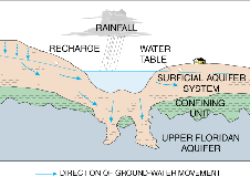
| Figure 3. Generalized cross section showing ground-water flow and hydrogeology at a Florida ridge lake. |
More than 7,800 lakes cover an area of about 3,600 square miles, or about 6 percent of Florida. More than half the lakes occur on the sandy ridges of the central peninsula and are typically of sinkhole origin. Because of the mantle of permeable sands, ground-water flow systems predominate over surface drainage (fig. 3), making the central lakes district an important area of recharge to the upper Floridan aquifer system, the principal potable water supply for the State. The integral connection between lake and ground-water hydrology in Florida presents many challenges to lake managers attempting to maintain acceptable lake levels and prevent water-quality deterioration from residential and agricultural development.
Since 1995, USGS scientists, in cooperation with the Southwest Florida and St. Johns River Water Management Districts and the Florida Department of Environmental Protection (FDEP), have studied various aspects of lake hydrology. Ground water flows to lakes are being quantified using models. Ground-water exchange with 10 lakes was estimated using water budgets and geochemical tracers. Another study used nitrogen isotopes to identify sources of nitrate in the shallow ground water around lake basins. The USGS also is evaluating the effects on ground-water exchange and lake-water quality of augmenting lake levels in the lake district north of Tampa Bay with water from the Upper Floridan aquifer. Regional, multi-lake studies are underway to estimate ground-water inflow and historical lake-level fluctuations. USGS geologists recently used digital high-resolution seismic systems to collect geophysical data from 30 lakes in north-central Florida. Analysis of seismic profiles for each lake showed that central Florida lake development follows four sequential stages to maturity. Seismic profiles also were used to locate possible breaches in the confining layer that maintains water levels in the lakes.
National Water Quality Assessment (NAWQA) studies are being conducted in south-central Georgia and north-central Florida, and in south Florida areas, which cover about 19,500 square miles (fig. 1).
Studies indicate that fertilizer is a major source of nitrogen and phosphorus in south Florida. Estimated annual nitrogen loads are highest in outflows from the Caloosahatchee River basin and the major Palm Beach canals, and lowest in outflows from parts of the Big Cypress basin. Annual phosphorus loads are highest in the Peace River, and are also high in the Caloosahatchee River and major Palm Beach canals. Results of the 3-year intensive sampling program show that nutrient concentrations vary widely both seasonally and spatially in response to human and natural influences. The most frequently detected pesticides in surface waters are atrazine, metolachlor, and simazine; chlorinated hydrocarbon insecticides and PCB's were detected in fish and bottom sediments. DDT compounds were detected in 25 of 27 fish samples in 1995, sometimes in concentrations comparable to those detected in fish in the early 1970's. Ecological studies in south Florida were completed to determine the abundance and diversity of fish, invertebrates, and algae. This is of particular interest because of the extensive alteration of predevelopment patterns of water movement and storage. An assessment of ground-water quality in south Florida focused on the potential influence of land uses such as commercial, light residential, and citrus and winter vegetable farming.
The population of Florida increased by 7.4 million people (110 percent) between 1970 and 1995. Data collected by the USGS, in cooperation with the FDEP and water management districts, indicate that over this same period of time, freshwater withdrawals increased nearly 29 percent and saline water withdrawals increased 13 percent. Between 1990-95, however, Florida's freshwater withdrawals decreased by about 4 percent, due in part to conservation and more efficient irrigation systems. Orange County, in central Florida, is an area of tremendous population growth that has tripled ground-water withdrawals since 1968. A study is underway in Orange County to determine the effects of ground-water withdrawals on water levels and wetland viability, of urbanization on the natural regimes of streamflow, and of land use on surface- and ground-water quality.
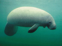
| Figure 4. Manatee in Florida waters. |
The endangered manatee is one of the most unique and best known Florida animals (fig. 4). Ongoing USGS research is providing wildlife managers with the tools necessary for the recovering populations of this marine mammal. USGS biologists with the Sirenia project are conducting long-term studies on the manatee's life history, population dynamics, and ecological requirements, and have pioneered several important tools, including a computerized photo-identification catalog and a radio-tag assembly for tracking manatees by satellite. Scientists also are studying manatee feeding habits and seagrass ecology in high-use manatee areas; the long-term, post-release success of manatees rehabilitated in captivity; manatee population genetics; and the effects of eliminating industrial warmwater discharges on manatee habitats. Warm water discharges from industrial sources help keep manatees warm in cold weather. The results of these studies will assist natural resources managers in determining factors important to manatee distribution patterns, fitness and ultimate survival. USGS Sirenia Project personnel are active members of the Florida Manatee Recovery Team, an interagency team under the direction of the U.S. Fish and Wildlife Service, which guides manatee research and management activities.
Scientists from the USGS Florida Cooperative Fish and Wildlife Research Unit, in collaboration with the Archie Carr Center for Sea Turtle Research at Eglin Air Force Base, the U.S. Fish and Wildlife Service, and several volunteer programs, are evaluating the effects of coastal dynamics and erosion on coastal fauna. Some beaches in the Florida Panhandle have erosion rates in excess of 35 feet per year, due especially to hurricanes. Vehicular traffic, coastal construction, and recreational boating further disturb coastal habitats. Studies are underway to improve understanding of the nesting habits of threatened loggerhead sea turtles on northwest Florida beaches, the inshore developmental and foraging habitat of the endangered Kemp's Ridley sea turtle, and the effects of erosion on shorebird nesting and foraging habitat.
For the past 8 years, the USGS and the FDEP have cooperated to produce, maintain, and revise (as needed) a digital base map for the State. New image products have been produced, and existing digital data categories and 1:24,000-scale maps have been revised. The collection of color infrared aerial photographs was initiated in September 1998 to produce digital orthophoto quadrangles (computer-generated images of aerial photographs having the geometric qualities of maps). Also, the USGS is updating 40 of Florida's most popular 1:24,000-scale topographic maps. Through the National Cooperative Geologic Mapping Program, the Florida Geological Survey is funded to conduct geologic mapping projects designed to aid in resolution of ground-water protection, waste disposal siting, mineral resource identification, and land-use planning issues.
|
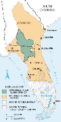
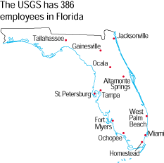
The USGS office locations
|
USGS State Representative USGS Home Page: Reports and products: |
| AccessibilityFOIAPrivacyPolicies and Notices | |
 |
|