Nevada State Banner

Index of Subjects

Mining and Water in the Humboldt Basin
Minerals Assessment and Research
Water Budget and Salinity of Walker Lake
Decision Support System for the Truckee and
spacethe Carson River Basins
National Water-Quality Assessment Program
Irrigation Drainage and Wildlife-Management Areas
Land Subsidence in Las Vegas Valley
Ground-Water Movement at the Nevada
spaceTest Site and Yucca Mountain
Topographic Mapping
Digital Raster Graphics
Geologic Mapping
Geologic Data Base for the Great Basin
Resource Assessment and Land Management
Collection of Hydrologic Data
Cooperative Programs

The U.S. Geological Survey (USGS) has been collecting and interpreting natural-resources data in Nevada for more than 100 years. The long-term commitment enables planners to manage better the resources of a State noted for paradoxes. Although Nevada is one of the most sparsely populated States in the Nation, it has the fastest growing population (fig. 1). Although 90 percent of the land is rural, most of Nevada's population is urban. Nevada is the most arid State and relies heavily on scarce water resources.

Figure 1

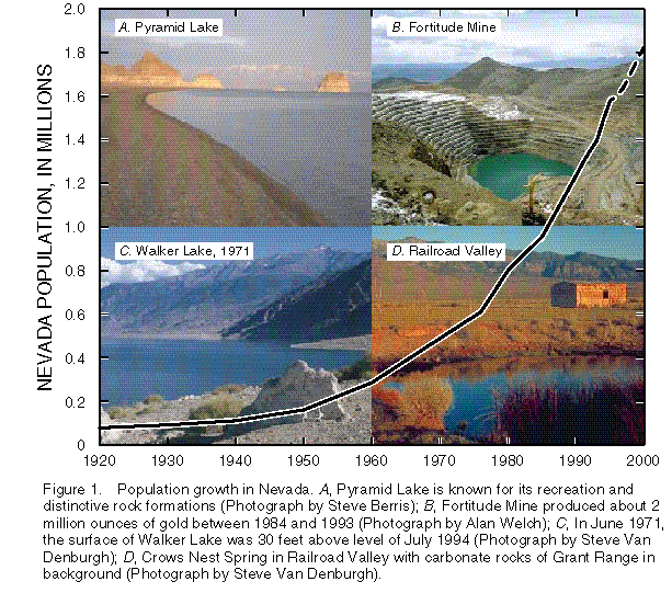
(Click on image for a larger version, 99K GIF)

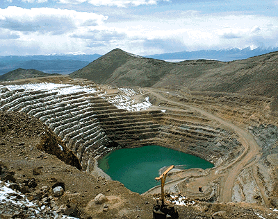
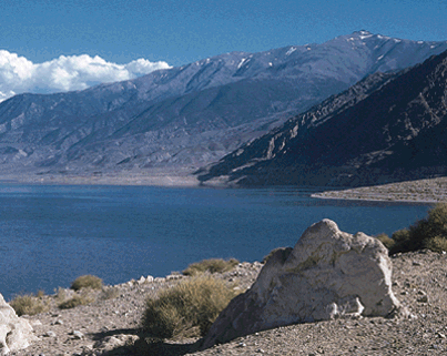
Figure 1. Population growth in Nevada. A, Pyramid Lake is known for its recreation and distinctive rock formations (Photograph by Steve Berris); B, Fortitude Mine produced about 2 million ounces of gold between 1984 and 1993 (Photograph by Alan Welch); C, In June 1971, the surface of Walker Lake was 30 feet above level of July 1994 (Photograph by Steve Van Denburgh); D, Crows Nest Spring in Railroad Valley with carbonate rocks of Grant Range in background (Photograph by Steve Van Denburgh).

Historically, mining and agriculture have formed the basis of the economy. Now, urban development and tourism also have become important. Scenic lakes, valleys, and mountains are the principal natural tourist attractions (fig. 1).

Collection, analysis, and interpretation of earth science information by the USGS are indispensable to sound planning. The USGS works with more than 40 local, State, and Federal agencies and Indian Tribes in Nevada to provide natural-resources information for immediate and long-term decisions.

-----

Mining and Water in the Humboldt River Basin

The advent of leaching processes that use cyanide (toxic in sufficient concentrations) for recovery of gold from lowgrade ore has resulted in a mining boom, particularly in the Humboldt River Basin. Several large open-pit mines are currently being dewatered at rates as high as 70,000 gallons per minute. A small portion of this water is used for operations and processing. Most of it is redistributed by infiltration, reinjection, irrigation of agricultural lands, or surface discharge into the Humboldt River or its tributary channels. The localized and cumulative effects are not well understood, especially in combination with effects of long-standing irrigation practices and increasing municipal growth.

In addition to potential hydraulic effects, changes in water quality, including increased stream temperatures and sediment transport might adversely affect endangered Lahontan cutthroat trout within the Basin. Finally, the quality of water in pit-water lakes is of long-term environmental concern because these water bodies lie along the Pacific Flyway used by migratory birds.

USGS scientists, in cooperation with the Nevada Department of Conservation and Natural Resources, the Nevada Bureau of Mines and Geology (NBMG), and the Bureau of Land Management (BLM), are studying geologic, geochemical, and hydrologic aspects of the Basin to increase understanding of the potential effect on resources. This information will be valuable to Federal and State agencies in making land- and resource-management decisions for northern Nevada.

-----

Minerals Assessment and Research

Because Nevada is a major minerals-producing State, mining is a significant industry. The future of mining and land use in Nevada depends on an improved understanding of the genesis of the known deposits and an assessment of the potential for occurrence of unknown deposits. USGS geologists, in cooperation with the Mackay School of Mines and private industry, are investigating the nature and origin of large, low-grade gold deposits like those found near Carlin. Research has led to new interpretations and models that can be applied in exploration and mineral-resource assessment. Related research into the age of these deposits suggests that they were formed about 30 million to 42 million years ago as a result of region-wide processes, including faulting, volcanic activity, intrusion of molten rock, and circulation of waters that carries a variety of metals.

USGS geologists are mapping geology in the Alligator Ridge mining district at the southern end of the Carlin Trend at 1:24,000 scale. The purpose of the mapping is to delineate ore controls for sediment-hosted ore deposits.

USGS scientists have used new computer techniques to reexamine rock-sample geochemistry for the Copper Canyon area. This area, which includes the Fortitude Mine (fig. 1B), contains major gold deposits. The new analysis reveals previously unrecognized patterns of metals around known deposits, which should help with understanding and locating new deposits.

USGS geophysicists have reexamined regional gravity data to focus on deeply buried rocks. Their research has found a persistent gradient in the gravity data that corresponds with the Battle MountainÐEureka mineral belt. These results provide direct evidence that mineral deposits are controlled by large regional scale crustal structures and provide enhanced understanding that aid in the exploration for new mineral deposits.

-----

Water Budget and Salinity of Walker Lake

Walker Lake (fig. 1C), which is a desert lake near Hawthorne, has gone dry several times during the last 10,000 years in response to changes in climatic and hydrologic conditions. The lake-surface altitude has decreased by 135 feet since 1882 when agricultural irrigation began in the basin. During the same period, dissolved-solids concentrations increased from about 2,500 to 13,300 milligrams per liter as of July 1994, threatening the Walker Lake ecosystem and the fish that depend on this ecosystem. The loss of the lake's trout fishery would affect the economy of the local communities. Upstream users who are economically dependent upon availability of water-rights appropriations also would be affected.

USGS hydrologists, in cooperation with the Walker River Paiute Tribe, have estimated changes in the salinity of Walker Lake in response to lake-level changes and salt inputs. The water budget shows that about 33,000 acre-feet per year of water in excess of the long-term average is needed to maintain the 1994 lake-surface altitude, assuming that hydrologic conditions as from 1939 to 1993 remain the same. To reduce the 1994 dissolved-solids concentration to 10,000 milligram per liter and to maintain a viable fishery, the lake-surface altitude would need to be raised about 20 feet, which is equivalent to about 700,000 acre-feet of water. To maintain this higher lake level, an additional 47,000 acre-feet per year would be needed. In 1995, the water level of Walker Lake rose about 5 feet in response to 200 percent of normal snowpack in the Sierra Nevada headwaters.

-----

Decision Support System for the Truckee and the Carson River Basins

The Truckee-Carson-Pyramid Lake Water Rights Settlement Act (Title II of Public Law 101Ð618) contains many requirements for U.S. Department of the Interior (DOI) agencies. The USGS is providing detailed water-resources data and analyses for the Carson and the Truckee River Basins of California and Nevada (fig. 2). A Federal river-monitoring network was designed and implemented to provide consistent long-term data. River basin simulation models are being developed, tested, and applied. Modeling efforts include precipitation-runoff models for 34 subbasins, flow-routing models of the Truckee and the Carson Rivers, temperature and total-dissolved-solids models of the Truckee River, and a river-operations model of the Truckee River. These efforts provide a framework for water-resource managers to assess alternatives for reservoir operations and water-rights allocations.

The USGS occupies a unique niche among the Federal agencies involved in settlement of the long standing legal, operations, and ecological issues in the Basins. Because the USGS does not have specific resource-management or regulatory responsibilities, it is recognized by other Federal agencies as an objective source of information to be used in further negotiations and in carrying out provisions of the Act.

Figure 2

(Click on image for a larger version, 33K GIF)

Figure 2. Urban and hydrological features in the Carson and the Truckee River Basins and Las Vegas Valley.
-----

National Water-Quality Assessment Program

In response to the lack of long-term, consistent information on water quality, the USGS developed the National Water-Quality Assessment (NAWQA) Program. NAWQA Program goals are to describe the status and trends in the quality of the Nation's water resources and to provide scientific understanding of the major factors that affect surface- and ground-water quality. The Nevada Basin and Range NAWQA Project, which includes the Las Vegas Valley area and the Carson and the Truckee River Basins (fig. 2), was initiated in 1991. Project scientists are using multidisciplinary approaches to compare and contrast the effects of urban and agricultural activities on water quality.

In 1995, project scientists participated with other DOI agencies [the National Park Service, the National Biological Service, the U.S. Fish and Wildlife Service (USFWS), and the Bureau of Reclamation (BOR)] to assess the occurrence of synthetic organic compounds and inorganic trace elements in Las Vegas Bay of Lake Mead and to evaluate their accumulation and harmful health effects in fish. The results of this assessment are being used to design a sampling strategy for delineating source areas of potentially harmful constituents.

-----

Irrigation Drainage and Wildlife-Management Areas

Since 1986, scientists of the USGS, the USFWS, and the BOR have studied and monitored water and wildlife resources of the Stillwater National Wildlife Refuge and other nearby wetlands near Fallon. The results of the work to date indicate that aquatic biota are adversely affected by human-caused hydrologic changes in the natural geochemistry of the Newlands Irrigation Project area.

In 1995, three synoptic studies were made just before and during the irrigation season. More than 200 measurements of drainflow and dissolved-solids concentration were taken, and about 80 water and sediment samples were collected for organic and inorganic chemical analysis and for toxicity tests. Preliminary results suggest that the greatest concentrations of potentially harmful constituents are from lands in the peripheral areas of the Newlands Project. Data and reports from the studies are used to determine potential ecological effects of water-management alternatives considered for implementation of Public Law 101Ð618 and for continued negotiations over water rights and environmental concerns in the Carson Desert and tributary basins.

-----

Land Subsidence in Las Vegas Valley

Land subsidence and earth fissures owing to ground-water withdrawal are ongoing problems in many parts of Las Vegas Valley. The USGS, in cooperation with the Nevada State Engineer, the Las Vegas Valley Water District, and the NBMG, is researching a three-dimensional model that was developed from recently established mathematical concepts. Land subsidence within the Las Vegas Valley has been well documented and partly controlled through the use of artificial recharge of water to the principal-aquifer system underlying the Valley.

Recent field data indicate that horizontal deformation owing to pumping is sufficient to cause fissures under certain geologic conditions. Simulation results indicate that fissures can form where differential subsidence is large or where sharp changes in aquifer thickness exist, such as over a buried bedrock high. Aquifer stresses are maximized at the margins of these geologic features, and resultant fissures are likely to migrate upward through brittle caliche deposits in the unsaturated zone.

-----

Ground-Water Movement at the Nevada Test Site and Yucca Mountain

At the request of the U.S. Department of Energy, the USGS is studying the hydrologic effects of activities at the Nevada Test Site (NTS). Nuclear weapons have been tested at this remote location north of Las Vegas since the early 1950's. The USGS operates the ground-water-monitoring networks at the NTS and Yucca Mountain, which is a potential location for the Nation's first high-level nuclear waste repository. Hydrologists and geologists are determining the regional and local subsurface controls on the rate and path of ground-water flow at the site. The results are crucial to understanding the potential for radionuclides and other contaminants to be transported within regional aquifers and to contaminate future public water supplies.

The USGS also is studying the long-term frequency and magnitude of floods in the Yucca Mountain area. In 1995, the USGS completed geodetic leveling measurements at Yucca Mountain. These data were used to determine vertical displacement across faults during historical times and establish rates of uplift.

-----

Topographic Mapping

Among the most popular and versatile products of the USGS are its topographic maps. These maps depict basic natural and cultural features of the landscape, including elevation contours, and have long been favorites with the general public for outdoor uses. Nevada is covered by 1,990 maps at 1:24,000 scale (1 inch equals 2,000 feet). The USGS has recently revised 13 topographic maps for the Carson City and the Lake Tahoe areas. The USGS also provides digital cartographic data for ground-water and hazard studies, and land and resource management.


-----

Digital Raster Graphics

The USGS, in cooperation with the NBMG, has prepared Digital Raster Graphics (DRG), or scanned topographic maps, of the entire State for the USGS 1:100,000-scale map series. The NBMG has placed these DRG's on its Internet site for the public to use, at: http://nbmg.unr.edu DRG's also are being produced at the 1:24,000-scale for the Truckee Meadows Fire Protection District in Washoe County to aid in fighting wildfires. Rather than relying solely on paper maps, firefighters can display the DRG's on a PCnotebook display in the field and print copies of the maps in the office as needed.

-----

Geologic Mapping

The National Cooperative Geologic Mapping Program provides for publication of maps by geologists in industry and universities, as well as those in State and Federal agencies. Geologic mapping, in cooperation with the NBMG, is conducted through this Program.

In Nevada, the STATEMAP component of the National Cooperative Geologic Mapping Program funds geologic mapping that is focused on mineral resources (gold, silver, lead, copper, tungsten) and on geologic hazards associated with faults in the western part of the State.

To provide important information about the geologic, geophysical, and hydrologic framework of Las Vegas and the surrounding area, a multicooperator project began in 1995. Initial mapping products are general-purpose, digital geologic maps at scales of 1:100,000 and 1:24,000. This mapping includes a detailed stratigraphic study of the basin-fill deposits of the Las Vegas Valley. As part of this study, an aerial-photographic study of the Lake Mead National Recreation Area was completed in 1995.

-----

Geologic Data Base for the Great Basin

On a regional scale, the USGS is compiling and using a large geographic data base for the Great Basin, which includes most of Nevada and parts of Utah, Idaho, Oregon, and California. A prototype display- and-analysis interface is being used by the USGS and the U.S. Forest Service. More than 60 digital data layers have been compiled; several have been published on CDÐROM. The data layers focus on geologic information that can be used for resource assessment and land management. These layers include surface geology and faults, analyses of rock samples and stream sediments, gravity anomalies, pluvial lakes, lithotectonic terranes, radiometric-age dates, active mines, mining permits, and standard map base layers.


-----

Resource Assessment and Land Management

As public agencies move toward integrating the human, biological, and physical aspects of Nevada lands, USGS scientists are providing a variety of resource assessments. In addition to those assessments, the USGS is assessing the fuel and nonfuel resources of the BLM's Winnemucca District and Surprise Resource Area in northwestern Nevada. Deposits of gold, silver, tungsten, oil, and gas, as well as geothermal energy, continue to be developed there. The BLM needs information to predict likely locations and effects of continued exploration and development. Land-management issues in the area include the presence of threatened and endangered species, withdrawal of public lands from minerals development (the proposed Black Rock-High Rock National Conservation Area), and the effects of mine dewatering on ground-water resources.


-----

Collection of Hydrologic Data

The systematic collection of hydrologic data and statistics on water use in Nevada is critically needed for the understanding and management of this vital resource. The USGS is the Nation's principal water-data-collection agency. USGS data are accessible to the public and provide a basic resource for engineers, universities, and public agencies.

Surface-water runoff is highly variable areally and seasonally throughout Nevada. In 1994, the USGS collected and published surface-water data from 187 gaging stations, 165 peak-flow stations, 66 springs, and 22 lakes and reservoirs. The long-term response of ground-water levels in Nevada to climatic variations and pumping is, for the most part, unknown. The proper planning and management of State water resources requires long-term information on ground-water levels and basin-wide estimates of recharge and discharge in the ground-water system. In 1994, the USGS collected and published water levels for 142 primary and 616 secondary observation wells. In cooperation with the Nevada Division of Water Resources, a new digital data base for managing welllog and wellpermit information was implemented in 1995.

The quality of water depends on many natural and human-induced factors and trends. Because USGS monitoring activities generally are focused on the ambient quality of rivers and aquifers rather than on permitted discharges, they provide an essential supplement to regulatory monitoring by other agencies. In 1994, the USGS collected and published water-quality data for 177 surfacewater sites, 154 wells, and 5 precipitation stations.

-----

Cooperative Programs

The USGS cooperates with more than 40 local, State, and Federal agencies and Indian Tribes in Nevada. Partnerships with local and State agencies typically are financed on a matching-funds basis. In addition to those agencies, the USGS cooperates with the city of Reno, Clark County, the Walker River Irrigation District, the Nevada Division of Environmental Protection, the Desert Research Institute, and the Federal Emergency Management Agency.

The USGS cooperates with the NBMG on many studies in the Great Basin. The NBMG is a research unit of the Mackay School of Mines at the University of Nevada, Reno, and is the State geological survey. Scientists at NBMG conduct research and publish reports on mineral resources and various aspects of general, environmental, and engineering geology.

from U.S. Department of the Interior, U.S. Geological Survey, Fact Sheet FS-028-96

For more information contact any of the following:

USGS State representative 333 West Nye Lane, Room 203 Carson City, NV 89706 (702) 887-7600 Fax: (702) 887-7621 Email: dc_nv@usgs.gov

Additional earth science information can be found by accessing the USGS Home Page on the World Wide Web at http://www.usgs.gov/

For more information on all USGS reports and products (including maps, images, and computerized data), call 1-888-ASK-USGS

The USGS provides maps, reports, and information to help others meet their needs to manage, develop, and protect America's water, energy, mineral, biological, and land resources. We help find the natural resources needed to build tomorrow and supply the scientific understanding needed to help minimize or mitigate the effects of natural hazards and environmental damage caused by natural and human activities. The results of our efforts touch the daily life of almost every American.

This fact sheet is also available in pdf format:

 FS-028-96.pdf 187K

USGS Fact Sheets (listed by state)
Maintainer: USGS Fact Sheet Team If you have suggestions for this page, please let us know!

http://water.usgs.gov/lookup/get?fs02896
Last modified: 1600 21 Feb 97 ghc