This document is also available in pdf format:
![]() fs-029-99.pdf
fs-029-99.pdf
The motto of the U.S. Geological Survey (USGS) "science for a changing world," describes the work of the USGS in Nevada, where the Federal earth-science agency has been monitoring or recording elements of change for more than 100 years.
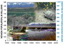
| Figure 1. State and Nation population increases. Clockwise from upper left: Irrigated lands in Carson Valley, Death Valley area, Stillwater National Wildlife Refuge, Lahontan cutthroat trout. |
During the 1990's, Nevada has had the fastest growing population in the Nation, with a 40 percent increase (fig. 1), compared to the national average of about 8 percent. Most of this growth has been in southern Nevada, where the Las Vegas metropolitan area is among the fastest growing in the Nation. This rapid growth affects the land, environment, animal and plant habitats, and water resources. Although most of the land is rural, most of Nevada's population is urban.
Most of the State's scarce water resources are fully appropriated. Population growth, wildlife-habitat maintenance, and a 6-year drought are some factors that have caused a change in water use. Irrigation is still the largest use of water in Nevada, amounting to more than 70 percent of all withdrawals. Since 1985, however, the amount of water used for public supply has increased from 8 percent of all withdrawals to 20 percent, and water use in mining has increased from less than 1 percent to 4 percent.
Collection, analysis, and interpretation of earth science and biological information by the USGS are significant contributions to sound planning. The USGS works with more than 40 local, State, and Federal agencies and Indian Tribes in Nevada to provide natural-resources information for immediate and long-term decisions. Information about USGS programs in Nevada can be found on the World Wide Web at http://nevada.usgs.gov/.
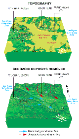
| Figure 2. Geophysics exposes structure underlying the Las Vegas Valley. Younger deposits shown in light green in the upper view are removed in the lower view to show complex topography underneath. |
The rapid population growth in southern Nevada adds approximately 4,000 people per month to the Las Vegas Valley. The USGS is using new technology to support mapping and geologic, hydrologic, and geophysical investigations of several southern Nevada areas.
Studies by USGS geophysicists have located large regional-scale crustal structures in southern Nevada that control the movement of ground water--sometimes as a conduit and sometimes as a barrier. The Las Vegas Valley shear zone (fig. 2) is a prominent structure that bends topography and geology, separating aquifers from areas north of the Las Vegas Valley from those in the valley. The Las Vegas Valley shear zone is a barrier to ground-water flow from the north and is a conduit for water from the Spring Mountains.
USGS digital earth-science information is addressing environmental issues and hazards along the lower Colorado River, including the Lake Mead National Recreation Area. USGS maps will provide information to millions of visitors about geology, land use, and water resources important to this scenic area. Information about these studies can be found at http://geology.wr.usgs.gov/docs/stateinfo/NV.html.
The National Cooperative Geologic Mapping Program performs geologic mapping in cooperation with the Nevada Bureau of Mines and Geology in several parts of Nevada. The STATEMAP component focuses on geologic hazards (primarily earthquakes, floods, and ground conditions affecting construction) in urban and suburban areas of southern Nevada and on mineral resource exploration and environmental protection elsewhere. The FEDMAP component has focused on geologic hazards of southern Nevada, and EDMAP has helped train geologic mappers at several universities.
The National Earthquake Hazards Reduction Program, which involves the USGS as well as Federal Emergency Management Agency, National Science Foundation, and National Institute of Standards and Technology, supports earthquake research, data collection, mitigation, and emergency preparedness in Nevada, the third most seismically active State in the Nation.
Las Vegas Wash transports urban runoff and treated sewage effluent from Las Vegas Valley into Lake Mead on the Colorado River. Lake Mead is the primary drinking water resource for the Las Vegas Valley and other southwestern metropolitan areas. Studies by the USGS found that concentrations of pesticides and organic compounds in bottom sediment from the Las Vegas Wash were greater than average values of concentrations at National Water-Quality Assessment sites throughout the United States. Investigations in other areas have linked some of these compounds to endocrine disruption, which has been identified in carp from Las Vegas Wash. Research is continuing on the sources, fate, and potential ecological and health effects of these compounds. A summary of these initial findings is on the World Wide Web at http://water.usgs.gov/lookup/get?circ1170.
The desert tortoise, a threatened species in the Mojave Desert of southern Nevada, is being studied in Piute, Eldorado, and Bird Spring Valleys by the USGS, in cooperation with the University of Nevada, Reno. Researchers are tracking tortoise movements to understand how urbanization and relocation practices affect tortoises and their habitat. About 1,500 tortoises have been relocated west of Jea--160 equipped with radio transmitters to track their location and survival. In Bird Spring Valley, 120 tortoises with transmitters are providing information about habitat, reproduction, movement, and survival. In Piute and Eldorado Valleys, researchers are developing methods to estimate population densities, and are x-raying female tortoises to determine frequency of reproduction and egg clutch size.
The U.S. Department of Energy (USDOE) has sponsored desert tortoise studies in Rock Valley on the Nevada Test Site (NTS) since the early 1960's. The USGS and USDOE are continuing these long-term growth studies, which provide the most complete records of known-aged tortoises, some of which are at least 37 years old.
At the request of the USDOE, the USGS is studying the hydrologic and geologic effects of activities at the NTS, where more than 900 nuclear tests were detonated between 1951 and 1992. These cooperative studies are providing important information about the potential hazards for radionuclides and other contaminants to be transported in regional aquifers to off-site areas of water use. Regional ground-water systems of eastern Nevada flow from recharge areas in the north to discharge areas in the south, such as Death Valley and the Colorado River. USGS scientists are modeling the Death Valley ground-water flow system to provide more information to decisionmakers regarding the effects of Yucca Mountain and Nevada Test Site activities. Information from these studies can be found on the World Wide Web at http://nevada.usgs.gov/doe_nv/.
In the southern part of the Death Valley flow system, the Ash Meadows National Wildlife Refuge is home to three federally listed endangered fishes and one federally listed aquatic insect. These species have decreased in number and distribution because their aquatic environment has been greatly altered and invaded by nonnative fishes. The USGS is studying habitat use and life history of the endangered fishes and their interaction with nonnative fishes. The U.S. Fish and Wildlife Service (USFWS) is using this information to restore stream habitat on the Ash Meadows National Wildlife Refuge.
The Truckee-Carson-Pyramid Lake Water Rights Settlement Act contains many requirements for Department of the Interior (DOI) agencies. The USGS is providing detailed water-resources data and river-basin simulation models for use in negotiating the Truckee River Operating Agreement, which will be critical to the successful implementation of the Settlement Act.
Listed as a federally endangered species in 1967, the cui-ui lake sucker is endemic to Pyramid Lake and is important to the current economy and traditional culture of Paiute Indians at the Pyramid Lake Reservation. Waste discharges to and water diversions from the Truckee River since the late 1800's have disrupted the spawning habitat in the river above Pyramid Lake. In an attempt to revitalize the Pyramid Lake fishery, the Marble Bluff Fish Passage Facility was completed in 1976 to bypass the Truckee River Delta. The facility has met with only partial success. USGS models of cui-ui population responses to Truckee River flows are supporting development of a revised Cui-ui Recovery Plan.
Lake Tahoe is renowned for its high alpine setting and deep, clear waters. Recognizing these attributes, President Clinton signed an Executive Order in July 1997 directing Federal agencies to establish a formal interagency partnership to assure coordination and efficient management of federal activities within the Lake Tahoe Basin.
Human activity has accelerated the decline in clarity and quality of this once pristine lake. Since 1979, the USGS has been involved in waterquality sampling of streams in the Lake Tahoe Basin. As part of this cooperative effort with several agencies, streams are monitored for suspended-sediment and nutrient contributions to the Lake. In 1990, the USGS began monitoring ground-water flow in the basin.
USGS efforts in response to the July 1997 Presidential Order include sampling water for methyl tert-butyl ether (MTBE) and other gasoline additives. The USGS has twice sampled several locations in the lake at differing depths, as well as tributary streams and other alpine lakes in the Tahoe basin. Both times, the USGS found compounds related to gasoline byproducts in all samples from Lake Tahoe and adjacent lakes.
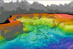
| Figure 3. An exaggerated perspective view of a large failure of�the Lake Tahoe lake margin. The view is from the east, looking west toward McKinney Bay near Tahoe City, Calif. The land is gray, the lake floor is colored (blue the deepest), and areas that have not been surveyed. are black. A debris tongue, shown in green and at the center of the view, is 4.5 miles wide and 5.6 miles long. |
Another effort related to the Presidential Order was updating the bathymetry of Lake Tahoe. Recent advances in marine sonar capabilities allow mapping the bathymetry of large underwater areas. The USGS used this advanced technology on Lake Tahoe in the summer of 1998 (fig. 3). The two types of maps that resulted provide the multidisciplinary Lake Tahoe research community a dataset upon which to build their studies. Information on activities from the Federal partnerships for Lake Tahoe is available at the Lake Tahoe Information Clearinghouse on the World Wide Web at http://tahoe.usgs.gov/.
Once widespread in streams and lakes of the Great Basin, the range of Lahontan cutthroat trout (LCT) has decreased due to habitat destruction and introduction of nonnative fishes. The current stream habitat supports 10 percent of the LCT former range, and in lakes, LCT occupy less than 1 percent of their former range.
Only two self-sustaining LCT lake populations persist in their native habitats, the Summit Lake LCT in the Quinn River/Black Rock Desert subbasin in Nevada and the Independence Lake LCT in the Truckee River basin in California. The Summit Lake LCT represent the healthiest and most stable population whereas the Independence Lake LCT have been near extinction for the past 25 years.
USGS scientists are researching those factors most influential in LCT population dynamics. Information gained from this research is intended to provide the USFWS and others with guidance for enhancing survival and recovery of LCT.
The Humboldt River Basin includes many of the Nation's largest gold deposits. Open pit gold mines tapping the Carlin and Battle Mountain ore bodies are some of the richest in the world. Dewatering these pits to allow deep mining has resulted in major interbasin water transfers, and disposal of the water has doubled the base flow of the Humboldt River. Concerns of the Bureau of Land Management (BLM), the USFWS, and the State about the long-term cumulative effects of this regional-scale dewatering formed the basis for a cooperative Humboldt River Basin Water Resources Assessment with the USGS. During the first phase of this study, historical trends in ground-water levels were documented and water budgets were estimated for valleys in the middle Humboldt River basin. The USGS work on the second phase began in 1999, and includes modeling regional ground- and surface-water resources. Information about USGS work in the Humboldt River Basin is on the World Wide Web at http://nevada.usgs.gov/humb/.
The USGS is assessing mineral deposits in the Humboldt River basin. The USGS, in cooperation with the BLM, is mapping the environmental signatures of mineral deposits to provide important long-term land-use planning information. Data from the Nevada Gold Project, a study of the origin of precious metal deposits, is intended to enhance the assessment. The USGS, in cooperation with the Mackay School of Mines, the mining industry, and the Nevada Bureau of Mines and Geology is modeling gold deposits, including those along the Carlin ore body, which contributes more than 35 percent of the total annual gold production of the United States. Preliminary results of the gold project studies are available on the World Wide Web at http://caldera.wr.usgs.gov/OF98-338/.
The USGS completed coverage of digital raster graphics for the State from the 1:24,000-scale topographic maps. These maps depict lakes and streams, highways and railroads, boundaries, and geographic names. Contour lines depict altitude and shape of terrain. Nevada is covered by 1,991 maps at this scale, which are useful for civil engineering, land-use planning, natural-resource monitoring, and other technical and scientific applications. These maps are favorites with the public for outdoor uses, including hiking, camping, and backcountry hunting and fishing.
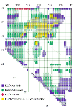
| Figure 4. Availability of digital orthophoto quadrangles (DOQ's) for Nevada. |
The USGS also completed Digital Elevation Model (DEM) coverage for Nevada. The DEM's are digital files of terrain altitudes for ground positions at regularly spaced horizontal intervals. DEM data correspond to the USGS 7.5-minute topographic quadrangle map series. The DEM's can be used to create maps with three-dimensional perspectives of the landscape to assess slope and location for vegetation and habitat mapping, hydrologic modeling for flood analysis, and hazard mitigation.
The USGS, under the DOI High Priority Base Data Program and in cooperation with the Natural Resources Conservation Service and Farm Service Agency, is producing Digital Orthophoto Quadrangles (DOQ's; fig. 4). The DOQ's are scanned aerial photographs with distortion and displacement removed. The DOQ's can be used for updating land-use and land-cover maps, natural-resource inventory and mapping, and delineating boundaries.
|
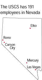
The USGS office locations
|
USGS State Representative USGS Home Page: Reports and products: |