|
|
The U.S. Geological Survey (USGS) provides the Nation with reliable,
impartial earth science information to describe and understand the Earth.
In North Dakota, the USGS collects data and conducts interpretive
investigations in cooperation with more than 30 local, State, and Federal
agencies and Indian Tribes. These basic data and issue-relevant
investigations provide the types of information on water, biological,
energy, and mineral resources that are needed on a continuing basis by
those who are responsible for managing the State's natural resources. |

|
|
Devils Lake Basin is a 3,810-square-mile closed drainage basin. (A closed
drainage basin has no outlet to the ocean.) About 3,320 square miles of
the drainage area is tributary to Devils Lake. Lake levels were recorded
sporadically from 1867 to 1901, when the USGS established a gaging station.
For the period of record, the maximum lake level was 1,438 feet above sea
level in 1867, and the minimum lake level was 1,400.9 feet above sea level
in 1940. On June 30, 1996, the lake level was at 1,437.7 feet above sea
level. In response to the rising water levels, the Devils Lake Basin
Interagency Task Force, which comprises many State and Federal agencies,
was formed in May 1995 to find and propose intermediate (5 years or less)
solutions to reduce the impacts of high lake levels (fig. 1). Analyses of future lake-level
probabilities and associated economic damage estimates are required to
evaluate the benefits and costs of proposed flood-control or
lake-stabilization projects.
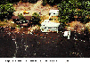
(Click on image for a larger version, 176K GIF)
|
|
Figure 1. Home being flooded by the rising water
levels of Devils lake. | |
The USGS, in cooperation with the North Dakota State Water Commission
(NDSWC), conducted a study to estimate future lake-level probabilities.
Probability data were used by the U.S. Army Corps of Engineers (USACE) to
develop damage-frequency relations for Devils Lake. Periodically updating
the model to reflect the most recent hydrologic conditions for Devils Lake
allows the Task Force to base decisions on the most up-to-date hydrologic
information. The USGS is helping the USACE and the NDSWC in their Devils
Lake Stabilization Feasibility study to understand how various outlet
options affect future lake levels and water quality of Devils Lake. The
study also will help determine how the various outlet options could affect
the hydrology and water quality of receiving streams.
For the flood-control and lake-stabilization studies, many map products
recently have been produced for the Devils Lake Basin. In addition, 19
1:24,000-scale topographic maps were revised. High-resolution digital
elevation models are being developed to assist State and Federal agencies
in making critical management decisions. |
|
|
|
Among the most popular and versatile products of the USGS are its
1:24,000-scale topographic maps (1 inch on the map represents 2,000 feet on
the ground). These maps depict basic natural and cultural features of the
landscape, such as lakes and streams, highways and railroads, boundaries,
and geographic names. Contour lines are used to depict the elevation and
shape of terrain. North Dakota is covered by 1,464 maps at this scale,
which are useful for civil engineering, land-use planning, natural-resource
monitoring, and other technical applications. These maps have long been
favorites with the general public for outdoor uses, including hiking,
camping, exploring, and back-country fishing expeditions.
The USGS has been working with State and Federal representatives to
coordinate and produce standard products and digital cartographic data in
North Dakota to meet a variety of user needs. Its geographic location in
the Northern Great Plains, mixture of mineral resources and agriculture,
and segmented population distribution are important factors that affect
natural-resource and habitat-management issues. The availability of basic
categories of digital cartographic data, such as elevation, hydrologic, and
transportation data sets, will allow for improved natural-resource
management, hydrographic investigations, and modeling of various physical
processes by using geographic information system (GIS) technology. These
activities in North Dakota exemplify how government agencies can work
together to reduce duplication of effort and resources used, while
increasing efficiency in managing their respective responsibilities.
|
The State of North Dakota established a Geographic Information System
Technical Committee (GISTC) and the State Mapping Advisory Committee (SMAC)
by Executive Order in May 1995. These committees will work with the USGS
and other Federal agencies to coordinate state GIS and mapping activities,
which include digital spatial data holding and clearinghouse activities.
The GISTC will keep governmental agencies and the public informed with
respect to GIS technologies and GIS projects, standards, and digital
spatial data availability, and the SMAC will coordinate and prioritize
mapping requirements in the State. |
|
|
|
Nationally consistent and comparable information is needed to make valid
regional and national statements about water-quality conditions now and in
the future. The USGS's National Water-Quality Assessment (NAWQA) Program
was established to address these needs. The goals of the NAWQA Program are
to describe the status and trends in the quality of a representative part
of the Nation's surface- and ground-water resources and to provide
scientific understanding of the natural and human factors that affect water
quality.
The Red River of the North (Red River) study unit was started in 1991 (fig. 2) to assess the water-quality issues of
nutrients and pesticides from nonpoint sources. Local and regional issues
also were identified through a study-unit liaison committee and considered
in the Red River study unit assessment. These included soil erosion,
sedimentation, natural salinity from ground water, and contamination from
point sources, particularly to the Red River. Intensive data collection
included water chemistry in streams and shallow aquifers; suspended
sediment and bottom sediment in streams; the variety and number of fish,
aquatic insects, and algae in streams; and contaminants in fish tissues was
completed in 1995.
|

(Click on image for a larger version, 64K JPEG)
|
|
Figure 2. Red River of the North National Water-Quality
Assessment (NAWQA) Program study unit. |
The Red River study is producing water-quality information that is useful
to policymakers and water managers at all government levels. For example,
the amount and types of pesticides and nutrients measured in streams and
surficial aquifers are compared with estimates of land applications of
these compounds for various landscapes, seasons, and weather conditions
within the study area. The NAWQA study has fostered cooperation among
State agencies in North Dakota and Minnesota and various Provincial and
Federal Canadian agencies. |
|
As the United States emerges into the next century, coal will continue to
be a major source of energy. Coal usage accounts for one-third of the
total energy and more than one-half of the electricity generated in the
United States. Even with substantial increases in energy conservation and
in the use of natural gas to meet increased demand for energy, coal
continues to be a major contributor. New technologies that use coal will
require resources that fulfill defined quality parameters. The Clean Air
Act with its amendments of 1990 has placed renewed interest on coals that
are low in ash, sulfur, and hazardous air pollutants (HAP's). The
location, quantity, and quality of the Nation's coal resources that will be
consumed over the next 20 years, classified particularly by the best end
use, will be necessary information for national and regional planners. The
Tertiary age coals of North Dakota, Montana, and Wyoming are known for
being low in sulfur and ash, but detailed studies of the distribution of
HAP's have only recently been undertaken. The USGS has developed models
for HAP distribution on the basis of coal depositional environments and
tectonic controls that influence coal-forming basins in these States and,
in cooperation with scientists from State and other Federal agencies, is
evaluating the viability of these models in anticipation of increased
demand for compliant coals over the next two decades. This is an important
step because most of the coals in North Dakota, Montana, and Wyoming are
publicly owned. As part of the National Coal Assessment, the USGS is
working closely with the North Dakota Geological Survey (NDGS) to identify
coal resources, which include those resources potentially suitable for
export, on public and private lands within the State. These coal resources
are being identified and characterized with regard to quantity and quality.
Products that result from the National Coal Assessment will be useful to
all levels of government, which include regulatory, information, and
management agencies, as well as industrial and academic research teams. |
|
|
|
North Dakota faces long-term challenges related to land-use and
land-management practices and engineering construction. Use of the land
contributes to environmental changes (erosion, reservoir siltation) and
natural hazards (floods, landslides, swelling and collapsing soils). The
USGS, in cooperation with the NDGS, is involved in studies to provide
information about the distribution of geologic resources and to identify
potential consequences of land-use and land-management practices. The
distribution, thickness, and chemical, physical, and engineering
characteristics of surficial geologic deposits are being mapped as part of
the compilation of the Quaternary Atlas of the United States. Bedrock
geology, areas of active surface processes (erosion, deposition), areas of
geologic hazards, and other aspects of geology and hydrology that affect or
are affected by continued development of the land surface in parts of North
Dakota are being mapped in detail as part of a regional study of
environmental change in the Missouri River drainage basin.
|
statemap is one of the external funding opportunities offered by USGS
National Cooperative Geologic Mapping Program. Agreements are open to the
State Geologic Surveys. Proposals focus on such issues as ground-water
quality, geologic hazards, landfill siting and management, oil and gas
assessments, coal quantity, sand and gravel resources, and economic mineral
development. For example, statemap funds detailed geologic and
paleontologic mapping that is needed to make land-use decisions in Theodore
Roosevelt National Park, and that is being used to develop visitor programs
and interpretive materials on the geology of the area. |
|
The Earth Science Information Centers (ESIC) provide information about USGS
programs, products, and technological developments to the public. The ESIC
in Bismarck was established under a cooperative agreement between the USGS
and the NDGS. As part of the national ESIC network, this office provides
information on such earth-science topics as cartography, hydrology,
geohydrology, aerial photography, and land use. It is supported by the
USGS with reference materials, technical assistance, training and outreach
activities, and access to USGS data bases. |
|
|
|
The USGS, in cooperation with about 30 local, State, and Federal agencies,
operates an extensive hydrologic data-collection program. During 1996, the
program provided for the collection of data at 173 streamflow and
lake-level stations, 141 ground-water observation wells, 185 water-quality
and sediment stations, and 2 atmospheric-deposition stations. Current-year
data, which are published annually, are critical for daily administrating
and managing of water resources, determining the extent and severity of
droughts, characterizing and predicting conditions during floods, and
monitoring the effects of human activities on streamflow, ground water, and
water quality. The data also are essential to interpretive studies that
provide information for making decisions about water issues that
potentially affect all North Dakotans. Locations where surface-water data
have been collected over the years by the USGS are shown in figure 3.

(Click on image for a larger version, 32K GIF)
|
|
Figure 3. Surface-water data -collection sites in North
Dakota. | |
Data at 38 streamflow stations and 3 reservoir sites are being relayed on a
real-time basis to the USGS computer in Bismarck. These data can be
accessed immediately on the North Dakota District Home Page on the World
Wide Web at:
http://srv1dndbmk.cr.usgs.gov/public/
Streamflow and stage information for the last 7 days is provided in graphic
form along with such information as station location and length of record.
The importance of the streamflow network was demonstrated during the floods
of July and August 1993 and April 1996, when streamflow data transmitted by
satellite telemetry were used by several agencies to manage storage and
releases from reservoirs and to forecast floods. |
|
|
|
The USGS, in cooperation with the NDSWC and the NDGS, has completed
reconnaissances appraisals of ground-water availability and quality in each
county in North Dakota. The county ground-water studies determined the
availability, movement, recharge, discharge, and quality of water in
glacial and bedrock aquifers. Information from the county studies has
provided a scientific basis for addressing many ground-water issues, such
as water availability and water allocation.
|
In 1993, the USGS, in cooperation with the NDSWC, began a series of studies
to describe the water resources of the State by river basin. The first
study, which is being done in the James River Basin, describes the
hydrologic system of the Basin and includes analysis of the major rivers
and related reservoirs, wetlands, major types of aquifers, soil system, and
climate. Study results are useful to water-management officials and the
public for making informed decisions about water projects or other issues
related to North Dakota's water resources. |
|
Since the construction of E.A. Patterson Lake, which is a reservoir on
Heart River near Dickinson, sedimentation and nutrient loading have caused
limited success in fish production. Excessive algae blooms have concerned
the local citizens as well as local and State officials. The USGS, in
cooperation with the city of Dickinson, is conducting a study to understand
better the water quality of the Patterson Lake Basin. This study is part
of the much larger Patterson Lake Diagnostic/Feasibility Study Plan.
Information from this plan is being used by local and State agencies to
improve management of the Basin. |
|
The Clean Water Act requires all States to implement a total maximum daily
load (TMDL) process for surface water where water-quality controls are not
adequate to achieve in-stream standards. A TMDL process results in an
allocation of loads for point and nonpoint sources. As part of this
process for a reach of the Red River of the North in the vicinity of Fargo,
North Dakota, and Moorhead, Minnesota, the USGS conducted a cooperative
study with the North Dakota Department of Health and the Minnesota
Pollution Control Agency. The study used a water-quality model that was
calibrated for ice-free conditions and verified the model under ice-cover
conditions. On the basis of the agreement between the measured and
simulated values or concentrations, the model was found to be capable of
simulating water quality for ice-free and ice-cover conditions. The model
is being used by State water-resource managers to evaluate loads in the
reach. |
|
Grassland fires pose a serious threat to agricultural and urban areas.
Grassland fire danger conditions exist when dry grasses are present and
hot, dry, and windy weather conditions prevail. In response to a need for
timely information on grassland conditions, the USGS provides vegetation
condition, or "greenness," information derived from satellite data to the
North Dakota Forest Service. The satellite observations from the USGS
provide weekly statewide updates of greenness conditions. The greenness
information is sent to the National Weather Service in Bismarck where it is
combined with daily weather information to forecast fire-danger conditions.
Whenever severe conditions exist, information is provided to emergency
monitoring centers and the news media for broadcast to the public. |
|
|
|
The USGS Biological Resources Division (formerly the National Biological
Service) conducts research and provides the scientific data needed for
sustained economic benefits from and conservation of the grassland
ecosystems of the northern Great Plains. Ongoing research at the Northern
Prairie Science Center (NPSC) in James-town, includes studies to document
the wildlife values of the Conservation Reserve Program, which removed
about 36 million acres of marginal farmland from agricultural production
and enhanced its value as food and cover for wildlife; to assess impacts of
habitat fragmentation on grassland birds, which include waterfowl; to
contain the spread of invasive weeds; to assess the ecological functions of
natural and restored prairie wetlands; to determine the effect of
agricultural practices upon sedimentation and chemical contamination of
prairie wetlands (fig. 4); to determine
predation rates on grassland birds and to document the ecology of their
mammalian predators; to determine survival rates and causes of mortality of
waterfowl broods; and to develop methods to inventory amphibians and
nocturnal wetland birds. Information that pertains to the biota of the
Great Plains are made available on NPSC's Home Page on the World Wide Web
at:
http://www.npwrc.usgs.gov/ |

(Click on image for a larger version, 160K GIF)
|
|
Figure 4. Many studies in North Dakota focus on the
hydrologic and biological functions and values of prairie wetlands. |
|