![]()
Map from U.S. Geological Fact Sheet 036-99
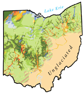 |
| Figure 3. Glacial deposits in Ohio. The map shows surface glacial till deposits in green, sand and gravel deposits in yellow-orange, and silt and clay deposits in blue. Unglaciated areas are light brown. Darker colors, which indicate thicker deposits, can be used to trace old valleys, filled with complex glacial deposits, across the central part of the State. |