This document is also available in pdf format:![]() fs-038-99.pdf
fs-038-99.pdf
The Columbia River is a prized natural resource of the Pacific Northwest. The river is used for navigation, hydroelectric power generation, outdoor recreation, and also has various heavy industries along its banks.
 image: 36KB |
| Figure 1. Otters and other wildlife in the Columbia River Basin are exposed to waterborne contaminants. |
As a result of urbanization, agricultural development, and industrialization throughout the basin, fish, wildlife, and human populations in and near the river are exposed to contaminants from runoff and atmospheric deposition. Industrial pollutants and agricultural pesticides have been associated with abnormal reproductive organs in river otters and decreased productivity of bald eagles. These and other contaminants also are suspected of being detrimental to several additional species. To assess the overall health of the Columbia River ecosystem, scientists from the USGS Forest and Rangeland Ecosystem Science Center, the USGS Oregon District, the U.S. Fish and Wildlife Service, and other Federal and State agencies are evaluating levels of contaminants in water and sediments and monitoring wildlife for contaminant accumulation and health effects (fig. 1).
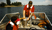 image: 68 KB |
| Figure 2. USGS hydrologists prepare to deploy a semipermeable-membrane sampling device in the Columbia River. |
Organic contaminants, even in low concentrations, can accumulate in the fatty tissues of animals and cause health problems. Such very low concentrations are not measurable using conventional sampling methods, so USGS scientists are using a new technology--semipermeable-membrane devices (SPMD's)--to measure contaminants in the Columbia River Basin (fig. 2). Each SPMD consists of a thin membrane filled with a fatty compound. The SPMD is placed in the river, where it accumulates organic contaminants and thus acts as a "virtual fish."
To monitor the effects of contaminants on wildlife, several species of fish, more than 250 nesting pairs of ospreys (fish-eating birds), and river otters from the Columbia and Willamette Rivers are being studied to evaluate accumulation of contaminants in fatty tissues, general health, and productivity.
The use of advanced sampling techniques such as the SPMD, coupled with tissue analysis of wildlife in the Columbia River Basin, will enable an unprecedented understanding of the effects of manmade organic contaminants on a river ecosystem.
Volcanic eruptions and large earthquakes have affected the Pacific Northwest in the past and represent future hazards as well. USGS scientists recently completed several products designed to inform public officials and the public of volcano hazards. Volcano-hazard assessment reports, with accompanying hazard-zone maps, were released for the Newberry and Crater Lake areas (Volcano Hazards at Newberry Volcano, Oregon: U.S. Geological Survey Open-File Report 97-513, and Volcano and Earthquake Hazards in the Crater Lake Region, Oregon: U.S. Geological Survey Open-File Report 97-487). Both reports describe the kinds of eruptions that have occurred in the past and the areas that might be affected by future eruptions. The reports also provide preliminary estimates of the probability of future events, based on the frequency of past activity. In addition, the Crater Lake report evaluates earthquake hazards in that region.
A new video, "At Risk: Volcano Hazards from Mount Hood, Oregon," uses footage of recent eruptions at similar volcanoes around the world to provide a glimpse of the types of events that might occur during future eruptions of Mount Hood, their potential effects on the area around the volcano, and areas at greatest risk. The video is available from the Northwest Interpretive Association, 3029 Spirit Lake Highway, Castle Rock, WA 98611, ph: (360) 274-2127.
Crustal earthquakes are another geologic hazard that could affect the populated regions of western Oregon. Although crustal earthquakes are relatively rare on any given fault, faults exist beneath the most heavily populated regions of western Oregon and Washington, and a quake on any one of them could have devastating consequences.
Much of western Oregon is underlain by shallow, slightly magnetic volcanic rocks. By measuring the Earth's magnetic field near the ground, USGS scientists are learning about faults that cut and offset the volcanic basement rocks. These measurements are made with a magnetic sensor called a magnetometer, which is usually attached to a low-flying airplane.
The USGS has been acquiring aeromagnetic data from the Coast Range of western Oregon and Washington to help identify geologic hazards (fig. 3). For example, aeromagnetic anomalies along the Mount Angel Fault (MAF), the likely source of the magnitude 5.6 Scotts Mills earthquake in 1997, reveal its location even where it is concealed beneath valley deposits. These studies also indicate that the Mount Angel Fault is connected with the Gales Creek Fault (GCF). Determining whether the Gales Creek-Mount Angel Fault is capable of producing a large earthquake will require additional studies.
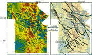 image: 41KB |
| Figure 3. The colors on these aeromagnetic maps of the Portland-Salem area indicate the intensity of the magnetic field near the ground surface, which in turn reflects the magnetic properties of underlying volcanic rocks. Both maps show the same magnetic data; the map on the right highlights interpreted geologic structures. The dotted lines on the map show the location of several magnetic linears, some of which are caused by faults. These magnetic data are being used in conjunction with geologic mapping and other earth-science studies to characterize faults in the northern Willamette Valley. Faults: MAF, Mount Angel Fault; GCF, Gales Creek Fault; OF, Oatfield Fault; EBF, East Bank Fault; CMF, Canby-Molalla Fault. KM, kilometer; nT, nanotesla. |
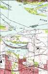 image: 126KB |
| Figure 4. Digital Raster Graphics (DRG's) are used by the USGS to produce other map products or to assess the completeness of digital data from outside sources. |
To facilitate implementation of the Northwest Forest Plan, the USGS, other Federal agencies, State agencies, counties, and private organizations initiated Baseline97, a project to construct a statewide, 1:24,000-scale digital base map coverage of Oregon. The coverage is composed of Digital Line Graphs (transportation, streams, elevation contours, boundaries, and Public Land Survey data); Digital Elevation Models (DEM's); and Digital Raster Graphics (DRG's) (scanned images of USGS topographic maps) (fig. 4).
The Baseline97 coverage is used for spotted owl and aquatic-habitat management. The Regional Ecosystem Office is using Baseline97 data in a Federal-State effort to delineate Oregon watershed boundaries. Using DRG's as a backdrop, the Bureau of Land Management (BLM) Oregon State Office is digitizing boundaries for this watershed-delineation project.
Through the Oregon Plan and the Coastal Salmon Restoration Initiative, the State seeks to restore salmon and trout resources to sustainable levels while still maintaining economic and other benefits. The Willamette River, a designated American Heritage River, is a focus of the Oregon Plan because of the relation between its water quality and affected salmon populations.
River-flow modeling is an integral part of the Oregon plan. The USGS, other Federal agencies, the Governor's Watershed Enhancement Board (through the Coastal Landscape Analysis and Modeling Study group), Polk County, the Southwest Provincial Interagency Executive Committee, and the State Elevation Committee are creating an elevation data set for western Oregon consisting of 10-meter-resolution digital elevation models (DEM's). DEM's are well-suited for certain surface-modeling applications. These DEM's accurately depict stream gradients and networks in river basins.
DEM's also are used in Oregon to investigate landslide potential. Scientists at Oregon State University and the Oregon Department of Forestry utilize DEM data for slope models used to produce maps that specify the relative risk of landslides throughout western Oregon.
Digital orthophoto quadrangle maps (DOQ's) are scanned aerial photographs in which the distortions and displacements caused by camera orientation and terrain are removed. DOQ's produced by the USGS cover the area represented by one-quarter of a standard USGS 7.5-minute, 1:24,000-scale topographic map. DOQ's have many applications. For example, the BLM uses DOQ's to check the accuracy of stream and road locations on maps and to digitize additional features. The Department of Agriculture's Natural Resources Conservation Service and the Farm Services Agency use DOQ's for soil surveys and to develop conservation and crop plans with farmers. DOQ's are available through USGS Earth Science Information Centers and the Global Land Information System Web site at http://edcwww.cr.usgs.gov/webglis/.
USGS ground-water investigations are helping State and local agencies deal with rapid growth in the 4,500 square-mile upper Deschutes Basin, one of the fastest growing regions in Oregon. Ground water must supply the water needs for all new development in this region because, for most uses, surface-water resources are fully appropriated. The ground-water system is hydraulically connected to streams, and ground-water use can, therefore, reduce streamflow. Reduced streamflow is a concern because of its possibly adverse effect on recreation and on fish that migrate upstream to breed.
Data collection and analysis by the USGS, in cooperation with the State of Oregon, local government agencies, and the Confederated Tribes of the Warm Springs Reservation of Oregon, has provided quantitative information about the connection between ground water and streamflow. A computer model developed during this study provides the ability to estimate the effects of development scenarios on streamflow. This ability is intended to help resource managers protect streamflow while providing sufficient ground water to accommodate the predicted growth in the Deschutes Basin.
Another issue in the Deschutes Basin is the hundreds of water wells that could be affected by the sealing of leaking irrigation canals. Unlined canals in the basin lose about 300,000 acre-feet of water annually through leakage, and efforts are underway to line the canals to reduce this loss. Most of the water lost from canals percolates to the ground-water system, artificially recharging aquifers and raising water levels. Many residents have come to depend on this source of water to supply their wells, and lining canals will likely cause some wells to go dry. The USGS upper Deschutes Basin ground-water study will provide water managers and well owners with information on the likely effects of canal lining.
 image: 26KB |
| Figure 5. High concentrations of arsenic in wells and springs (shown by red circles) are widespread in the Willamette Valley; the highest known concentrations are in the south. |
Data from USGS investigations are helping State water-resources and health officials determine the extent of arsenic contamination in ground water in the southern Willamette Valley, a densely populated region (fig. 5). A recent study found that the arsenic concentrations in water from many wells exceeds the U.S. Environmental Protection Agency maximum contaminant levels for drinking water, and the concentration in water from one-fifth of the wells sampled exceeded the World Health Organization standard. The study results will enable health officials to identify areas where well owners are at risk and should test and, possibly, treat their drinking water. A report detailing the results of the study, "Arsenic in Ground Water of the Willamette Basin, Oregon," Water-Resources Investigations Report 98-4205, can be accessed online at http://oregon.usgs.gov/pubs_dir/online_list.html.
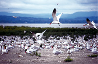 image: 53KB |
| Figure 6. Predation of migrating juvenile salmonid fishes by colonies of Caspian terns adversely affects salmon and steelhead recovery efforts. |
The Oregon Plan is an unprecedented State effort to restore declining salmon and trout populations. In support of the initiative, USGS biologists at the Oregon Cooperative Fish and Wildlife Research Unit are studying predation by Caspian terns on young steelhead, coho salmon, and chinook salmon passing through the Columbia River estuary (fig. 6). Breeding terns from a large colony on Rice Island consume an estimated 6 to 25 percent of juvenile salmon and trout leaving the Columbia-Snake River Basin each year.
While continuing to study tern population trends and factors that may influence predation, biologists also are testing methods of reducing fish losses. Studies completed in 1998 suggested that moving the tern colony to another island might help larger numbers of fish reach the ocean.
The Northwest Forest Plan, adopted in 1994, set new directions for forest ecosystem management in the Pacific Northwest. In support of the plan, the USGS, the BLM, Oregon State University, and the Oregon Department of Forestry formed the Cooperative Forest Ecosystem Research Program. The major goals of the Program are to conduct research to provide forest managers with new information to evaluate current and proposed practices for management of forest ecosystems and to facilitate development of sustainable forest practices. An integral part of the Program's mission is to work closely with resource managers, researchers, and decisionmakers to develop and convey information needed to implement ecosystem-based management.
USGS office locations
|
USGS State Representative 10615 S.E. Cherry Blossom Dr. Portland OR 97216 (503) 251-3200 FAX (503) 251-3470 USGS Home Page http://www.usgs.gov
|
| AccessibilityFOIAPrivacyPolicies and Notices | |
 |
|