Banner

Index of Subjects

The U.S. Geological Survey (USGS) provides Earth-science information to help manage our natural resources. This Fact Sheet describes some USGS activities in South Carolina.

bar

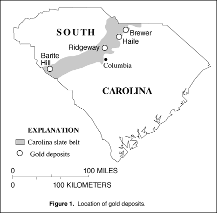
Potential for Gold Discoveries

Production of gold was important in South Carolina during the 1800's and it is again contributing to the State's economic growth as a result of the opening of four gold mines (Brewer, Haile, Ridgeway, and Barite Hill) in the last decade. To support and help sustain this economic growth, the USGS has applied its geological and geochemical expertise to investigations of the gold deposits and their geologic setting in rocks of the Carolina slate belt ( fig. 1). These studies provide information to evaluate the potential for discovery of new deposits. Preliminary reports on issues of special interest for exploration, or that address environmental concerns, are released as soon as information is available.

Figure 1

(Click on image for a larger version, 33K JPEG)

Figure 1. Location of gold deposits.
bar

Topographic Mapping

Among the most popular and versatile products of the USGS are its 1:24,000- scale topographic maps (1 inch on the map represents 2,000 feet on the ground). These maps depict basic natural and cultural features of the landscape, such as lakes and streams, highways, and railroads, boundaries, and geographic names. Contour lines are used to depict the elevation and shape of terrain. South Carolina is covered by 566 maps at this scale, which is useful for civil engineering, land-use planning, natural-resource monitoring, and other technical applications. These maps have long been favorites with the general public for outdoor uses, including hiking, camping, exploring, and back-country fishing expeditions.

bar

Mapping Partnerships

The USGS has collected digital data, in cooperation with the South Carolina Department of Natural Resources (DNR), to provide transportation, hydrography, and boundary digital line graph (DLG) data coverage for approximately 70 percent of the State; DLG data for an additional 10 percent of the State are being produced. A cooperative program for producing statewide digital orthophotoquad (DOQ) coverage has been started by the USGS and the DNR; presently, about 10 percent of the State is covered by DOQ's. A DOQ is derived from digitized aerial photographs, with displacement caused by camera tilt and terrain relief removed; it combines the image characteristics of a photograph with the geometric qualities of a map. DOQ's are being used by State agencies to analyze and evaluate the Edisto River Basin's natural resources. Other uses include classifying and analyzing soils; monitoring and evaluating wetlands; allocating environmental permits; locating archeological and historical sites; assessing fisheries; producing agricultural-productivity indexes; and identifying streams and cultural resources.
bar

Earth Science Information Centers

The Earth Science Information Centers (ESIC's) provide information to the public about USGS programs, products, and technological developments. The ESIC in Columbia, established under a cooperative agreement between the USGS and the South Carolina DNR's Land Resources Information Center, is an active contributor to USGS data bases. As part of the national ESIC network, this office provides information on such earth-science topics as cartography, geography, digital data, remote sensing, geology, geophysics, geochemistry, hydrology, geohydrology, aerial photography, and land use. The USGS supports it with reference materials, technical assistance, training and outreach activities, and access to USGS databases.
bar

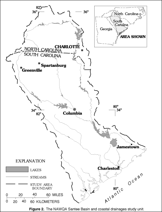
National Water-Quality Assessment Program

The USGS began a National Water-Quality Assessment (NAWQA) Program in 1991. The long-term goals are to describe the status of and trends in the quality of a large representative part of the Nation's surface- and ground-water resources and to identify all the major factors that affect the quality of these resources. In 1994, NAWQA Program assessment began in the Santee River Basin and coastal drainages in North Carolina and South Carolina (fig. 2).

Figure 2

(Click on image for a larger version, 194K GIF)

Figure 2. The NAWQA Santee Basin and coastal drainages study unit.

The following water-quality issues have been identified as high-priority, regional issues of concern to State and local water-resource managers and are addressed by the Santee-Coastal NAWQA Program Study:

  • Enrichment by nitrogen and phosphorus has caused algae in many lakes and rivers in the study area to increase, which reduces dissolved-oxygen concentrations and adversely affects fish and other aquatic biota.

  • Sediment erosion due to land use increases water turbidity (which increases the cost of treatment for public consumption and industrial use) deposits silt in reservoirs, covers fish spawning beds, and causes aesthetic problems.

  • Runoff from urban areas transports trace elements and synthetic organic compounds that can seriously affect the quality of water and wildlife habitats in the receiving streams.

  • Pesticides and nutrients can contaminate surface and ground water.

  • Mercury is present in elevated concentrations in fish that inhabit streams in the Coastal Plain of South Carolina. The State has imposed fish-consumption limits.

Long-term assessments by the Santee-Coastal NAWQA Program are a key attribute of the Program--not only for defining trends, but also for understanding water quality in the study area. This understanding will be achieved by carefully analyzing and interpreting long-term data sets of chemical and biological characteristics of water resources and comparing those data to data on hydrology, land-use changes, and management practices.

bar

Geologic Mapping

Water-bearing sands beneath the Coastal Plain are a traditional source of water for municipalities, industry, and landowners. However, this resource is endangered by overuse, saltwater encroachment along the coast, and hazardous-waste contamination. Although long-standing Federal and State ground-water programs continue to provide information on ground-water quality and quantity, the USGS also is studying alternating layers of sand and clay sediments that form the actual conduits for ground-water flow. In cooperation with the DNR and the U.S. Department of Energy (Savannah River Site), the USGS studies sands as deep as 3,500 feet. By studying samples from existing test holes and by drilling new test holes, the USGS can describe and trace the complex distribution of the numerous Coastal Plain aquifers. Additionally, the test holes provide samples for chemical and bacteriological studies of the ground water and sediments, as well as sites for monitoring ground-water levels. This combination of traditional ground-water studies with studies of the physical architecture of the water-bearing sediments will greatly improve the understanding of the Coastal Plain ground-water system.

bar

STATEMAP

The statemap component of the USGS National Cooperative Geologic Mapping Program funds important geologic mapping conducted by the South Carolina Geological Survey. The object of this USGS-coordinated program is to produce geologic maps of areas for which knowledge of geology is important to the economic, social, and scientific welfare of the State.

During the past year, the emphasis of this mapping has been on the rapid growth I-85 corridor in the Greenville-Spartanburg area and to the environmentally sensitive area in the upper Lake Marion area. Areas of increasing populations in the Greenville-Spartanburg area of the Piedmont and in the upper Lake Marion area in the Coastal Plain are increasing the demand on limited natural resources. The most demanding challenge to the Greenville-Spartanburg area is maintaining a sustainable water supply while it operates under the constraint of "no new reservoirs." The threat of pollution is the greatest challenge in the upper Lake Marion area.

Understanding the geology in these areas is important because of the relation between pollution and solid-waste disposal, surface recharge, and ground-water flow and discharge and because of the need to ensure natural resources for the future. Identifying natural resources to meet industrial and urban growth demands, as well as protecting and conserving sensitive natural resources, are objectives of statemap. In both of the map areas, the focus is on obtaining knowledge capable of mitigating the water-related issues and providing land-use planners with information on the natural resources of both areas.

bar

Mineral Resource Data System

The USGS now has two minerals databases: the traditional Mineral Resources Data System (MRDS) and the Mineral Availability System (MAS), which was transferred into the USGS from the Bureau of Mines. Between them, the minerals data bases contain information on hundreds of thousands of deposits and mineral-processing locations around the world. These data bases are the principal tools that the USGS uses for mineral-resource and mineral-environmental research. In addition, this information is available to Federal and State agencies and the general public. The data bases contain information on more than 1,000 sites in South Carolina, including metallic and nonmetallic deposits. The information has been compiled in cooperation with the South Carolina Geological Survey.

bar

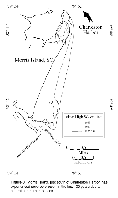
South Carolina Coastal Erosion Study

The USGS has initiated a study of the South Carolina coast, in cooperation with the South Carolina Department of Health and Environmental Control --Office of Ocean and Coastal Resource Management and the South Carolina Sea Grant Consortium, to develop a regional understanding of the processes causing coastal erosion. Information from the study can be used to preserve and enhance South Carolina's valuable coastal resources. The study is focusing on improving predictions of erosion by understanding nearshore physical processes and the regional geology (fig. 3). This large-scale regional investigation is revealing processes that cause shoreline and shoreface erosion which cannot be easily determined from local studies.

Figure 3

(Click on image for a larger version, 194K GIF)

Figure 3. Morris Island, just south of Charleston Harbor, has experienced severe erosion in the last 100 years due to natural and human causes.
bar

Metallic Mineral-Resource Potential

The USGS has completed a quantitative national assessment of mineral resources for five commonly used metals: gold, silver, copper, lead, and zinc. This assessment enables the USGS to respond quickly to requests for information about these mineral resources throughout the country from Congress, Federal and State agencies, industry, and the public. A report provides general mineral information to land-use planners who are concerned with resource management. An inventory lists significant known deposits, identifies areas with mineral potential, and estimates the quantity of each metal likely to be present. In South Carolina, tracts are delineated that may have undiscovered copper, lead, zinc and two types of gold deposits. The assessment can be used as a basis for more detailed studies.

As a complement to the national assessment, the USGS, in cooperation with State geological surveys including the South Carolina Geological Survey, is conducting a more comprehensive regional assessment of the known and potential metallic and industrial mineral resources in the eastern United States. The results of the regional assessment can assist land-management agencies, regional planners, industry, and local governments with adequate mineral supply at the lowest possible cost and ensure sound management of the region's resources. South Carolina contains identified resources of gold, copper, lead, zinc, silver, titanium, rare earths, zirconium, tin, refractory minerals, lithium, mica, and feldspar minerals of national and global importance. In addition, competition for land, water, and biological resources also affects the local availability of clay, limestone, sand and gravel, crushed rock, building stone, slate, aggregate, and other industrial mineral resources. These industrial minerals are needed for infrastructure repairs and building projects.

bar

Bioremediation

Ground water has been contaminated at thousands of sites nationwide due to leaking storage tanks, landfills, and spills. Most of these sites involve contamination by petroleum hydrocarbons and chlorinated solvents. The task of cleaning up these sites requires an assessment technique to determine which sites pose the most risk of exposure to humans or wildlife by way of streams, wells, or springs, and which sites pose little risk. At many sites there is some natural biodegradation of these contaminants. The USGS, in cooperation with the Naval Facilities Engineering Command, has developed an assessment technique to determine if biodegradation rates are sufficient to prevent contaminant migration to nearby streams, wells, or springs. The technique relies on traditional hydrogeologic studies to determine the rate and direction of ground-water flow and the absorptive capacity of the soil, and on microbiological tests in the field and the laboratory to determine the rate of biodegradation. The rates are entered into a computer model that simulates the distance that toxic concentrations will travel. When it can be shown that natural attenuation will degrade contaminants before they reach streams or wells, these processes can be used as a treatment strategy called "Intrinsic Bioremediation," which requires assessing treatment efficiency and long-term monitoring to verify contaminant containment.

The technique recently was applied to two sites at the Marine Corps Air Station Near Beaufort, South Carolina (fig. 4). Results showed that one site has clay soils, slow ground-water flow, and sufficient biodegradation to confine the contaminant plume. At another site with sandy soil, ground water moves too quickly for effective bioremediation. Additional remediation techniques, such as enhanced bioremediation or pump-and-treat, will be necessary to protect nearby streams, wells, and springs.

bar

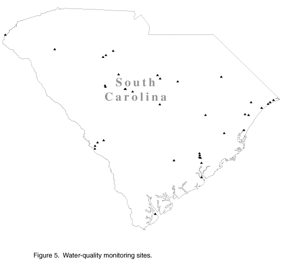
Hydrologic Data Collection

South Carolina's abundant surface- and ground-water resources are being stressed by the demands of a growing population. Careful management of water resources in the face of these pressures requires an extensive information base, which is the aim of the USGS. In cooperation with Federal, State, and local agencies, the USGS maintains an extensive network of data-collection stations that continuously monitor rainfall, water stage, streamflow, water quality, and ground-water levels. The data network includes 188 gages on rivers and lakes, 23 rain gages, 49 wells, and 48 water-quality monitoring sites (fig. 5). The data are stored in the USGS national data files and are available upon request. Additionally, the USGS has installed satellite telemetry equipment at most of its data-collection sites to provide water-resources data in near-realtime to the South Carolina District Office and to other agencies.

Figure 5

(Click on image for a larger version, 194K GIF)

Figure 5. Water-quality monitoring sites.
bar

Waste Assimilative Capacity of Streams within the Grand Strand

The Grand Strand is a rapidly growing resort area in Horry and Georgetown Counties on the northeastern coast of South Carolina. A recent USGS report provides information that water-resource managers and planners can use to ensure that plentiful, clean water is available for this economically important area. The report describes the ability of the Waccamaw River and the Atlantic Intracoastal Waterway near Myrtle Beach to absorb pollutants without affecting the water quality, especially, dissolved oxygen concentrations. Information on this ability, known as the assimilative capacity of the streams, helps the local water managers determine the most effective uses of surface-water resources while protecting the aquatic life in the streams. The report was prepared in cooperation with the Waccamaw Regional Planning and Development Council.

bar

Biological and Ecological Studies

The USGS Biological Resources Division (formerly the National Biological Service) conducts research on many aspects of South Carolina's ecosystems. Much of this research is done by the South Carolina Cooperative Fish and Wildlife Research Unit, located on the Clemson University campus, in close cooperation with State agencies and the U.S. Fish and Wildlife Service. USGS research activities include developing techniques for restoring forested wetlands along the Coosawhatchie River; conducting contaminant studies to assess the quality of water and sediment in the lower Savannah River and Charleston Harbor; and evaluating the effects of water-level changes on migratory bird habitat in National Wildlife Refuges and State wildlife management areas.

bar

Cooperating Agencies

The USGS cooperates with more than 29 Federal, State, and local agencies in South Carolina. Major Federal cooperators are the U.S. Department of Energy, the U.S. Navy, the U.S. Army, and the U.S. Army Corps of Engineers. State cooperators include the South Carolina Departments of Natural Resources, Health and Environmental Control, and Transportation. Local cooperators include cities, counties, and utility districts. Cooperative activities include water-resources-data collection, interpretive water-availability and water-quality studies, mineral-resources assessments, and mapping. When local and State agencies are involved, activities typically are financed on a matching-funds basis.

The USGS provides support to the South Carolina Water Resources Research Center at Clemson University, which conducts a program of research, education, and information and technology transfer.


from U.S. Department of the Interior, U.S. Geological Survey, Fact Sheet FS-040-96

For more information contact any of the following:

USGS state representative
720 Gracern Road.
Stephenson Center, Suite 129
Columbia, SC 29210
(803) 750-6100
Fax: (803) 750-6181
Email: dc_sc@usgs.gov

Additional earth science information can be found by accessing the USGS Home Page on the World Wide Web at http://www.usgs.gov/

For more information on all USGS reports and products (including maps, images, and computerized data), call 1-888-ASK-USGS

The USGS provides maps, reports, and information to help others meet their needs to manage, develop, and protect America's water, energy, mineral, biological, and land resources. We help find the natural resources needed to build tomorrow and supply the scientific understanding needed to help minimize or mitigate the effects of natural hazards and environmental damage caused by natural and human activities. The results of our efforts touch the daily life of almost every American.


This fact sheet is also available in pdf format:

 fs-040-96.pdf 205KB

http://water.usgs.gov/lookup/get?fs04096
Web version by: Patsy Campbell
Last modified: June 9,2009