This document is also available in pdf format:
![]() fs-047-99.pdf
fs-047-99.pdf
An increase in the loading of phosphorus to Lake Champlain since the early 19th century has resulted in accelerated plant growth and water-quality problems in the lake. Municipal and industrial wastewater, urban and agricultural runoff, and phosphate detergents are responsible for the elevated phosphorus levels. Since the Clean Water Act of 1972 was implemented, the amounts of phosphorus entering the Lake have been reduced, but algal growth is still at nuisance levels that reduce the clarity of the water. Additional reductions in phosphorus entering the lake are necessary to inhibit further algal growth, but an understanding of how phosphorus is cycled and transported in the Lake Champlain Basin is needed to develop effective reduction policies.
 |
|
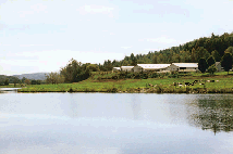
Figure 1. A typical dairy farm along the banks of the Winooski River, Middlesex, Vermont. |
In an effort to control pollutant runoff, planners and regulators implement Best Management Practices (BMPs). To determine if BMPs are working, and to plan for the reduction of specific pollutants, the long-term effectiveness of BMPs needs to be assessed. This need for assessment is particularly acute in the Lake Champlain Basin during the next 20 years due to the establishment of specific targets for reducing phosphorus loads to the Lake.
The USGS, in cooperation with the Vermont Department of Environmental Conservation, will be studying the long-term effectiveness of BMPs in the Lake Champlain Basin. BMPs will be implemented by the City of Burlington at an urban site in Engles-by Brook Basin. An agricultural site also will be selected in the year 2000. At each site, the USGS will continuously monitor streamflow and water quality for phosphorus and other nutrients.
A new bedrock map of Vermont is being compiled in a cooperative effort by the USGS and the Vermont Geological Survey. The 1:100,000-scale map also is being compiled and published in Geographic Information System (GIS) digital form. This map will provide baseline geologic information for such uses as water-supply development and ecosystem management. Funding for geologic mapping in Vermont is provided by the STATEMAP component of the National Cooperative Geologic Mapping Program. Digital geologic map products at a scale of 1:24,000 (1 inch=2,000 feet) are available from the Vermont Geological Survey.
USGS topographic maps covering Vermont's Green Mountain National Forest are scheduled for printing in 2000. In an agreement between the USGS and the U.S. Forest Service (USFS), the USFS will update the maps to show additional features required for national forest management.
The Vermont Center for Geographic Information (VCGI), in cooperation with the Federal Geographic Data Committee, the USGS, the Vermont Agency of Natural Resources, the U.S. Department of Agriculture-Natural Resources Conservation Ser-vice (NRCS), and Vermont's Regional Planning Commissions, is conducting a pilot project to integrate locally generated 1:5000-scale surface-water data with the National Hydrography Dataset (NHD). The NHD is a joint USGS and U.S. Environmental Protection Agency (USEPA) project to merge the USEPA's water-quality information with USGS stream centerlines for GIS analysis, reporting, planning, and monitoring. The VCGI pilot project will produce a NHD-compatible detailed surface-water GIS product that accurately corresponds with other state-GIS data layers, such as soils, roads, bridges, and orthophoto images.
The USGS and the Vermont Tax Department's Mapping Program have established a partnership to produce digital orthophoto quadrangles (DOQ's) as derivatives of the State's higher-resolution orthophoto imagery. Digital orthophotos are spatially accurate air photos that can be viewed on a computer screen in combination with other digital map features such as streams, roads, and elevations for accurate land-use assessment, soils and habitat mapping, and map revision. This innovative effort will provide government agencies and the public with image products of different resolutions and "footprints" of areas from the same photo.
On July 14–16, 1997, flooding in northern Vermont caused severe local damage and resulted in a Presidential disaster declaration. Erosion and deposition were significant at numerous locations, and local officials and residents are concerned that the accumulation of sand, gravel, and cobbles in stream channels magnified the severe flooding. Currently, Vermont stream-management policies restrict the removal of these materials.
 |
|
Figure 2. Surveying the channel of the Wild Branch in Wolcott, Vermont. |
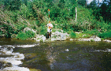
In response to this concern, the USGS, in cooperation with the Vermont Agency of Natural Resources and the Federal Emergency Management Agency, completed a study of the transport of streambed materials by rivers during floods. Rivers selected for the study included the Trout River in Montgomery, the Wild Branch in Wolcott, and the Lamoille River in Cambridge (fig. 2).
The USGS, in cooperation with the Vermont Agency of Transportation, is studying the flow-frequency characteristics of Vermont streams. Characteristics such as the magnitude and frequency of floods are used in the design of bridges, culvert openings, roadbed elevations, embankments, dams, or other structures near streams. This information also is used for floodplain mapping and management and establishing flood-insurance rates. The USGS will develop flow statistics for each of its stream-gaging stations in Vermont and develop relations between various basin characteristics and flood flows at those gaged sites. These relations will then be used to estimate flood discharges at ungaged sites. The USGS plans to develop software and a data base that can easily be used to develop flood-frequency estimates.
 |
|
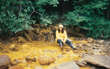
Figure 3. Copperas Brook carries acid-mine drainage from the abandoned Elizabeth Copper Mine near South Strafford into the Ompompanoosuc River. The yellow coating on the rocks is iron-rich precipitate from the drainage. |
An important issue in the northeastern United States is how best to allocate limited resources for land conservation in order to maintain diverse plant and animal populations. In Vermont, USGS scientists are constructing computer-based models to predict distributions of vertebrates and to determine the degree of protection through land conservation needed for regions of high vertebrate diversity. Digital maps describing land-cover patterns, vertebrate species distributions, and conservation areas are being used as tools to help provide critically needed information on relations between the distribution of terrestrial vertebrates and habitats in the region. The results of the project will assist government officials and land managers in making sound decisions for land conservation. The work is being supported by the Vermont Department of Fish and Wildlife and the U.S. Fish and Wildlife Service.
 |
|
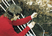
Figure 4. Hydrologist installing soil-temperature probes in a soil pit at Sleepers River. |
Research in the Sleepers River Watershed also is addressing how streamflow is generated and the water chemistry changes as basin size increases and land cover shifts from forest to agriculture. Results of the study show that frozen ground directly increases runoff of snowmelt waters and reduces movement of water to the ground-water system. Soil water from the unsaturated soil zone also is being collected to analyze how water and chemicals move down a hillslope to a stream.
|
|
|
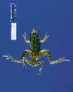
Figure 5. Deformed frog with an extra pair of hid limbs |
In Vermont, USGS scientists, in collaboration with State and Federal agencies, are surveying the extent of the malformations in frogs and investigating possible causes. Without understanding such causes, it is difficult to assess whether human health also is at risk.
Malformations could be caused by parasites or exposure to chemicals released into the environment. Substances such as herbicides, insecticides, and fertilizers contain chemical compounds that can mimic animal growth hormones. Accumulation of these chemicals can lead to abnormal limb development in frogs and other wildlife. Current research by USGS scientists is focusing on the effects of chemicals used to control mosquitoes and unwanted aquatic plants.
The public can assist the USGS amphibian monitoring program by reporting occurrences of amphibian malformations to the North American Reporting Center: phone 1-800-238-9801, narcam@usgs.gov, or website www.npwrc.usgs.gov/narcam.
A concern about the decline of the American woodcock during the last three decades across much of eastern North America has encouraged USGS scientists to study the demographics and habitat requirements of the popular game bird. In Vermont, the research is being carried out in cooperation with U.S. Fish and Wildlife Service (USFWS), the Vermont Department of Fish and Game, Dartmouth College, the Wildlife Management Institute, and the Ruffed Grouse Society. Two separate woodcock populations are recognized and managed by the USFWS. Both populations have dwindled since the early 1970's, with a greater drop in the eastern region (2.5 percent per year) than in the central region (1.6 percent per year).
To understand better how habitat modification is affecting the populations, USGS biologists are studying sources of mortality, survival rates, and patterns of woodcock movement and habitat use. Results of these studies will help management agencies set harvest regulations and identify beneficial forest management practices. The goal of the "American Woodcock Management Plan" is to stabilize and increase woodcock populations to 1985 levels by the year 2005.
In Lake Champlain, salmonid fish and predators, such as the sea lamprey, are being monitored to help natural-resource managers understand and maintain a balance between the aquatic populations and a healthy habitat. The USGS Vermont Cooperative Fish and Wildlife Research Unit in Burlington, in cooperation with the Vermont Department of Fish and Wildlife, the New York Department of Environmental Conservation, and the USFWS, provides assistance to managers in the Lake Champlain Basin on issues related to salmonid fish restoration and sea lamprey control.
The amount of water in Vermont's rivers, streams, lakes, and reservoirs is measured and monitored by the USGS hydrologic data-collection program. These data are used for:
| • | Forecasting floods and droughts.
|
| • | Flood-warning and flood-plain management.
|
| • | Water-resources planning.
|
| • | Designing and operating projects for water supply, hydroelectric power,
flood control, and pollution control.
|
| • | Designing bridges and culverts.
|
| • | Hydrologic research. |
 |
|
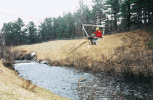
Figure 6. Technician is preparing to measure streamflow by lowering a current meter from a cable car suspended over a river. |
Real-time streamflow data, by way of satellite and telephone telemetry, are available on the USGS Vermont home page for 26 locations throughout the state at http://vt.water.usgs.gov
This information is critical for flood forecasting and response duties of the National Weather Service, Vermont Emergency Management Agency, and other State and local officials.
Changing patterns in water use require that available supplies and current and predicted future demands be carefully evaluated. Without adequate information, decision makers are not equipped to resolve critical issues related to water supply, hydropower, snowmaking, water quality, and the potential effects of streamflow withdrawals on ecosystems. The USGS, in cooperation with the Vermont Department of Environmental Conservation, Water Supply Division, is working to improve the State's water-use information for the management of water resources. Assistance is provided to the State in the collection, analysis, dissemination of water use data, and the creation of a statewide water-use data base.
|
|
|
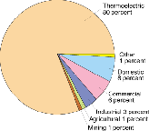
Figure 7. Total freshwater use in Vermont, by category, in 1995. |
|
The office locations
|
USGS State Representative |