[an error occurred while processing this directive]
This document is also available in pdf format:
 fs-052-99.pdf
Wyoming
Wyoming’s social and economic development is driven, in large part by its
natural resources. For more than 100 years, the U.S. Geological Survey (USGS)
has been involved in studies of the geology, geography, water resources, and,
more recently, the biological resources of Wyoming. Results of these studies
provide natural-resource managers and policymakers with essential earth science
information needed to make decisions about the use and conservation of Wyoming’s
resources.
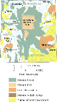
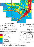
Integrated Geoscience Studies of the Greater Yellowstone Area
Integrated geoscience studies conducted by the USGS provide information that
can be applied to the stewardship of the natural resources of Yellowstone
National Park (YNP) and the Greater Yellowstone Area (GYA) (fig. 1). The studies
include investigations of hydrothermal systems in relation to magmatic activity,
caldera development, active faulting, fluid flow, ore-forming processes, and
impacts on wildlife, plants, and climate. Additional studies include:
| • |
using geophysics to understand the "plumbing" system of the
Yellow-stone caldera, geothermal systems, and to help locate active faults;
|
| • |
surveying the bottom of the northern part of Yellowstone Lake to
complement ongoing studies of active hydrothermal vents and explosion craters;
|
| • |
mapping surficial mineralogy and vegetation communities to show the
distribution of white pine, which will be used to define bear habitat; and
|
| • |
establishing a geochemical database to help evaluate the environmental
health of YNP, including its wildlife, through time. |
Geologic mapping is intended to provide information about geologic influences
on environments of particular plant and animal species. Life cycles of some
plants and the animals that eat the plants are affected by circulating
hydrothermal water enriched with trace elements.
The role of the USGS in the GYA, in cooperation with local, State, and
Federal agencies, is to transfer and apply USGS technology, and to distribute
information to the scientific community, citizens, public interest groups, and
the media. Exhibits planned by the National Park Service (NPS) may include
information from USGS studies and demonstrate the relevance of earth science to
the stewardship of Federal lands.
The USGS is producing digital geologic maps (1:100,000 scale) for the GYA, as
part of the National Geologic Map database This activity is an initiative under
the Greater Yellowstone Ecosystem program of the USGS, a cooperative program
with the NPS, U.S. Forest Service, and other local, county, and State agencies
in Wyoming, Montana, and Idaho. The digital geologic maps will be combined with
other spatial databases for studies of wildlife habitat, geologic hazards, and
the geochemical effects that different rock types have on water, plants, and
animals in the area.
 |
|
images sizes 90KB
Figure 2. Part of digital orthophoto
quadrangle of the Old Faithful area in Yellowstone National Park.
|
The USGS also has constructed digital orthophoto quadrangles (DOQ’s) and
digital elevation models (DEM’s) for parts of the GYA (fig. 2). DOQ’s are
scanned aerial photographs for 7.5-minute quadrangles (scale 1: 24,000) in which
distortion and displacements caused by the camera orientation and terrain are
removed. DEM’s are digital files of terrain elevations for ground positions at
regularly spaced horizontal intervals. Ongoing work provides base-map data for
the GYA in Wyoming, Montana, and Idaho. The data are intended to be used for
studying population demographics, estimating visitor and recreation demands,
studying the effects of human and animal interactions, identifying geothermal
hazards, studying noxious weeds and land use, and protecting natural resources.
Cartographic and Geographic Data
Through several programs the USGS produces and publishes basic cartographic
and geographic data for Wyoming. Much of the work is in cooperation with other
agencies. In one highly successful program, the Wyoming State Engineers Office,
Wyoming Water Development Commission, State Lands Office, cities and counties,
the Bureau of Reclamation, and the U.S. Department of Agriculture provide
cooperative funding for producing DOQ’s. Because DOQ’s are referenced to
ground control, the images may be loaded into a geographic information system
(GIS) and used with other data for analysis. Of the 1,922 quadrangles for
Wyoming, only about 300 remain to be mapped as DOQ’s.
Other activities include the establishment of State data-sharing
clearinghouses, with the help of the Federal Geographic Data Committee; the
clearinghouses are components of the National Spatial Data Infrastructure. Also,
the Wyoming Natural Resources Data Clearinghouse of the University of Wyoming,
the Greater Yellowstone Area Data Clearinghouse, and the Wyoming Spatial Data
Clearinghouse of the State Office of GIS are partners with the USGS in making
geospatial data accessible to the public. In addition to data coordination and
sharing roles, the USGS is involved in the Wyoming Geographic Information
Advisory Council, which provides leadership and establishes GIS policy for the
State of Wyoming.
Yellowstone River Basin National Water-Quality Assessment
The USGS is studying water quality in the Yellowstone River Basin in Wyoming,
Montana, and North Dakota as part of the National Water Quality Assessment
Program (NAWQA). Water-resource managers need, but commonly lack, sufficient
information for making effective management decisions and for evaluating
long-term changes in water quality. Changes in water quality can affect an
entire ecosystem, raising concerns about drinking-water quality, habitat
degradation or destruction, and loss of use of the water. The Yellowstone River
Basin NAWQA will provide needed information about surface- and ground-water
quality and the factors that influence water quality in the basin.
Water-quality issues in the Yellow-stone River Basin range from potential
degradation of pristine streams in headwater areas to industrial and
agricultural effects in downstream reaches. Specific issues include:
| • |
trace elements (for example, selenium and arsenic) originating from
sources such as leachate from mine spoils, leaching of soil, water from
geothermal areas, and uranium-rich rocks;
|
| • |
toxic compounds from leachate, pesticides, hydrocarbons, and industrial
and commercial waste;
|
| • |
increasing salinity in ground and surface water;
|
| • |
sediment problems in streams;
|
| • |
effects of dewatering of aquifers;
|
| • |
nutrient enrichment of ground and surface water from fertilizer
application and from animal and human waste; and
|
| • |
water quality on tribal lands. |
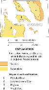
Pesticide Monitoring of Ground Water
The USGS is conducting a pesticide-monitoring program, in cooperation with
the Wyoming Department of Agriculture (WDA), in selected agricultural areas
(potentially in all 23 counties) to determine the extent of pesticides in ground
water. The WDA is implementing the State’s generic Management Plan for
Pesticides in Ground Water, in cooperation with other State and Federal
agencies, for the U.S. Environmental Protection Agency. Increased pesticide use
has raised concerns about the effects of pesticides on the environment and human
health. Ground water, the sole source of drinking water for rural residents in
many parts of Wyoming, is particularly susceptible to contamination.
 |
|
images sizes 34KB
Figure 3. Locations of wells where water
was sampled for pesticides, and the potential
vulnerability of ground water to pesticide contamination in Washakie County.
|
Initial sampling by the USGS has been completed in Goshen, Park, and Washakie
Counties and is underway in Laramie, Lincoln, and Fremont Counties. The sampling
strategy was based on the potential vulnerability of ground water to pesticide
contamination shown on maps created by the University of Wyoming Spatial Data
and Visualization Center (fig. 3). Eighteen pesticides and two degradation
products were chosen for analysis.
Shallow alluvial and terrace aquifers typically were identified as the
aquifers most vulnerable to pesticide contamination. Concentrations of all
pesticides detected in water from wells in Goshen, Park, and Washakie Counties
were less than the safe drinking-water standard or its equivalent established by
the Wyoming Department of Environmental Quality for municipal supplies. These
standards do not apply to private domestic well water, but the standards provide
a reference to the acceptable amount of chemicals in drinking water. Atrazine
was the most commonly detected pesticide. Trace amounts of atrazine were found
in more than one-half of the water samples from the three counties in which the
pesticide was detected.
Basic Hydrologic Data
|
|
|
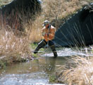
images sizes 97KB
Figure 4. A USGS hydrographer measuring
streamflow. Photo courtesy of the Wyoming Tribune-Eagle.
|
The USGS, in cooperation with many local, State, and Federal agencies,
collects hydrologic data at surface-water and ground-water sites throughout
Wyoming. Depending upon the information needed, the data are collected
continuously with automatic recording devices, intermittently, or by a single
sample or measurement (fig. 4). Since 1888, streamflow data have been collected
at more than 2,000 sites, and surface-water-quality data at more than 1,600
sites.
About 150 streamflow stations are operating (1999). All USGS data are
available to the public; streamflow data from many stations are available in
near-realtime on the World Wide Web. The hydrologic-data program is the
foundation upon which most other water-resources investigations are based.
Although the USGS has no management or regulatory function, the short-term
and long-term data acquired through this program have many uses. Local, State,
and Federal agencies use the data for daily and annual management of Wyoming
water, including allocation of water under State and Federal laws, enforcement
of water-quality standards, and design of highway bridges and culverts. Also,
the data are used for hydrologic investigations including:
| • |
developing improved data-collection methods,
|
| • |
describing and appraising water resources,
|
| • |
determining the extent and severity of droughts,
|
| • |
documenting floods and developing methods for estimating the magnitude
of floods of a given frequency, and
|
| • |
assessing the effects of human activities on surface-water and
ground- water resources. |
Invasive Weeds
To determine the impacts of invasive, nonnative plants on native plant
communities in forest, grassland, and wetland habitats, USGS scientists are
working in cooperation with the NPS, Bureau of Land Management (BLM) and
Colorado State University. New sampling techniques are helping researchers
pinpoint "hot spots" for exotic species and predict new areas of
invasion. Habitats with the highest numbers of native species, including
wetlands and streamside zones, are particularly vulnerable to nonnative weeds.
In such areas, the invaders often spread at the expense of unique or narrowly
distributed native species. Information gained in these studies is intended to
help scientists propose cost-effective strategies for nonnative weed eradication
and native habitat restoration.
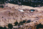
Big Game Use of Reclaimed Mining Lands
Researchers at the USGS Wyoming Cooperative Fish and Wildlife Research Unit
in Laramie compared big game animals’ use of native habitats and reclaimed
mining lands. The results of this study are intended to help mining companies
and government agencies design and implement reclamation projects in ways most
favorable to big game. Pronghorn antelope, mule deer, and elk each showed
distinct habitat preferences and distribution patterns, but all three used
reclaimed areas during all or part of the year (fig. 5). Particular features of
the vegetation on reclaimed lands were associated with greater use by different
game species. Pronghorn, for example, preferred reclaimed sites on which alfalfa
was present. Mule deer made consistent use of reclaimed grasslands, but elk used
those areas only during late fall and winter.
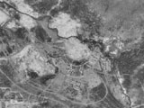
Energy-Resource Assessment
USGS scientists, in cooperation with the Wyoming State Geological Survey, BLM,
Office of Surface Mining, and coal-mine operators, are assessing the
availability, quantity, and quality of the coal, oil and gas, and coalbed
methane in the State (fig. 6). One major objective is to generate, store,
and manipulate the data in digital format so that it will be available for
analysis by using a GIS. The digital database will provide information to
potential users in a readily available format.
The coal-resource assessment includes
gathering information about geography, stratigraphy, geochemistry, and quality
of coal zones and beds in the State. Potentially minable coals included in the
assessment are associated with the 55–65-million-year-old Fort Union
Formation. The USGS has examined deposits in the Powder River, Hanna, Carbon,
and Green River Basins. Mining of these coal resources, especially those in the
Powder River Basin, contributes substantially to the State’s economy through
increased jobs and severance taxes.
Oil-and-gas resources in Wyoming are being assessed by the USGS as part of a
national study of 18 priority provinces in the United States that are estimated
to contain 90–95 percent of the Nation’s known and undiscovered natural-gas
resources. Provinces in Wyoming include the Greater Green River Basin and the
Wyoming Thrust Belt. The study integrates all of the elements of the petroleum
geology of a basin, including source-rock characterization, hydrocarbon
migration, timing of migration and structural evolution, sequence stratigraphy,
and reservoir quality.
Coalbed methane in the Powder River Basin is undergoing substantial
development. The methane has been estimated to be as much as 39 trillion
cubic feet. Resource managers need accurate basinwide and local gas-resource
estimates and content analyses. For this assessment, USGS scientists are using
data on coal geology, stratigraphy, and the reservoir to develop models of the
basin. Chemical analyses and density measurements will be performed on coal
cores collected from coalbed methane wells throughout the basin.
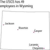
The office locations
|
USGS State Representative
2617 E. Lincolnway
Suite B
Cheyenne WY 82001-5562
(307) 778-2931
FAX (307) 778-2764
USGS Home Page
http://www.usgs.gov/
Reports and products
1-888-ASK-USGS

|