

|
NAWQA assesses watersheds as integrated systems, focusing on: Chemical concentrations of pesticides, nutrients, organochlorines, industrial chemicals, metals, dissolved solids, and radon. Physical condition of stream habitat, including vegetation, water flow, and stream shape. Biological status of fish, algae, mollusks, and insect communities.
|
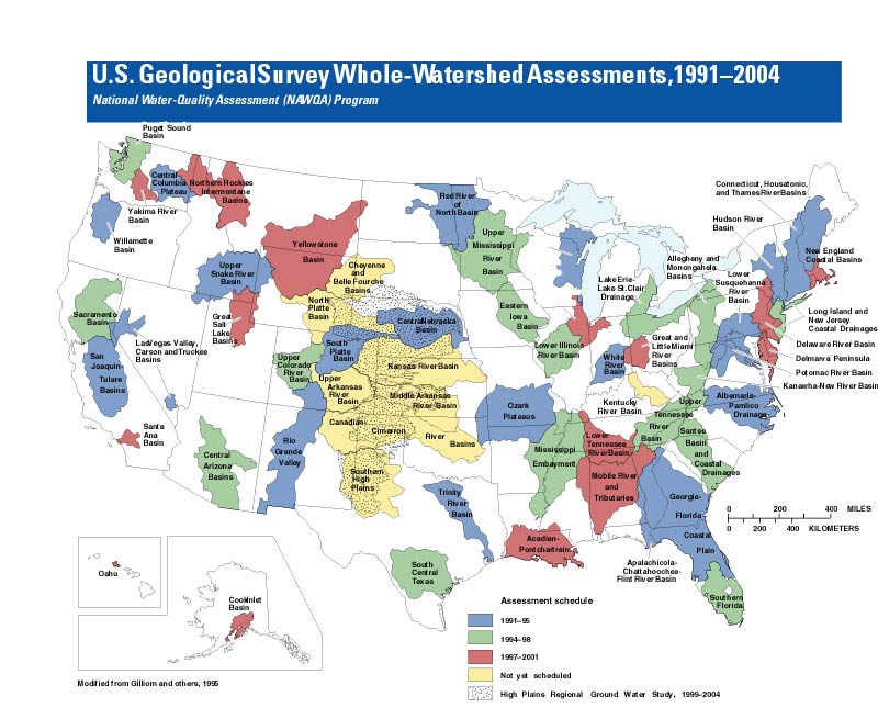
Beginning with a baseline assessment of pollutants related to urban and agricultural land use, the National Water-Quality Assessment (NAWQA) Program is building toward a fuller explanation of how and why water quality varies across the United States. In more than 50 major river, stream, and ground water systems (see map on reverse), NAWQA describes conditions, tracks trends, and investigates the human and natural influences on water quality.
Well-known river basins lend their names to
many NAWQA study areas, yet assessments look beyond rivers and streams.
Surface water, ground water, and the atmosphere are all connected, each
influencing the quality of the others in a hydrologic cycle. In keeping
with this insight, NAWQA studies consider all parts or "compartments" of a
watershed.Integration of the hydrologic cycle is just one aspect of NAWQA's "whole-watershed" approach. Another is the connection between water quality and ecology. In addition to monitoring water chemistry, scientists evaluate the size and diversity of aquatic communities, the quality of streambed sediments, and contaminant levels in fish tissue.
Issues identified as national priorities undergo special analysis by NAWQA's "national synthesis teams." Presently, teams are analyzing geographical patterns related to pesticides, nutrients, volatile organic compounds (VOCs), aquatic ecology, and trace metals.
Maintaining the Program's relevance to decisionmaking requires sustained interaction with stakeholders. Committees composed of government officials, resource managers, industry representatives, and other interested parties interact with NAWQA scientists as they design and carry out their investigations.
 NAWQA's multiscale geographical approach
makes its findings well suited to comparing conditions within a single
river basin and to comparing many river basins. Findings shed light on how
water quality changes through the seasons of a single year as well as over
several years. The dominant influences on water quality in coastal,
desert, and temperate settings can be compared. And it is possible to
compare and contrast the effects of
agricultural and urban areas more easily than ever before.
NAWQA's multiscale geographical approach
makes its findings well suited to comparing conditions within a single
river basin and to comparing many river basins. Findings shed light on how
water quality changes through the seasons of a single year as well as over
several years. The dominant influences on water quality in coastal,
desert, and temperate settings can be compared. And it is possible to
compare and contrast the effects of
agricultural and urban areas more easily than ever before.
 The Program analyzes data collected by Federal, State, and university
scientists to establish a springboard for its own investigations. Where no
historical water-quality data exist, NAWQA's first assessment becomes the
baseline.
The Program analyzes data collected by Federal, State, and university
scientists to establish a springboard for its own investigations. Where no
historical water-quality data exist, NAWQA's first assessment becomes the
baseline.NAWQA began monitoring the first 20 river basins in 1991, phasing in work in over 30 additional basins by 1997. This staggered schedule, in which about one-third of all study areas are under intensive investigation at any one time, allows the Program to function more cost effectively. Trends are assessed in each river basin every 10 years.
U.S. Geological Survey Whole-Watershed Assessments, 1991-2004 map.
The NAWQA Program promotes public access to water-quality information. Technical and interpretive publications are available free of charge. Please contact us.
Chief, NAWQA Program
U.S. Geological Survey
413 National
Center
Reston, VA 20192
phone: (703) 648-5716
fax: (703)
648-6693
email:nawqa_whq@usgs.gov
http://water.usgs.gov/nawqa
U.S. Geological Survey
Information Services
Box 25286 Federal Center
Denver, CO 80225
| Fact Sheet Theme Page | Environment | Hazards | Information Management | Resources |
| USGS | Biology | Geology | Mapping | Water |
U.S. Department of the Interior, U.S. Geological Survey