
This document is also available in pdf format:
![]() fs-107-97.pdf
fs-107-97.pdf
In 1996, the U.S. Geological Survey (USGS) and the Arizona Department of Envi ronmental Quality (ADEQ) completed a cooperative ground-water data-collection program in the Sierra Vista ground-water basin of southeastern Arizona. This Federal-State cooperative effort fulfilled the goals of both programs, increased the number of ground-water samples and associated data available to each agency, and provided an opportunity for quantifying differences between the agencies’ sampling and analytical techniques.
Sampling in the Sierra Vista Basin the USGS was part of the National Water-Quality Assessment Program NAWQA) for the Central Arizona Basins (CAZB) study area. The goals the NAWQA program include providing nationally consistent description current water-quality conditions for large part of the Nation’s water resources, defining long-term trends water quality, and understanding the natural and human factors that affect water quality (Gilliom and others, 1995). In 1994, the USGS began ground-water, surface-water, and biological studies the CAZB study area. Ground-water studies within the CAZB study area are focused on basins in which water quality has been substantially affected by human activities or has the potential to substantially affected.
Sampling by the ADEQ was completed as a part of the Ambient Groundwater Monitoring Program, which is based on the legislative mandate in the Arizona Revised Statutes §49-225 (Arizona Department of Environmental Quality, 1995) that authorizes the “ongoing monitoring of the waters of the State, including...aquifers.” Objectives of this mandate include determining the presence of pollutants and compliance with applicable water-quality standards, evaluating the effectiveness of the best management practices and effects of pollutants on public health and the environment, and identifying waterquality trends. Random sampling on a basin-wide basis is used by the Ambient Groundwater Monitoring Program to determine regional groundwater quality; targeted higher-density sampling that is related to specific land uses is conducted to determine potential effects on ground-water quality.
A retrospective assessment of ground-water quality in the Sierra Vista Basin was completed by the USGS before the cooperative data-collection effort began by using the USGS waterquality data base (DGNWIS) .
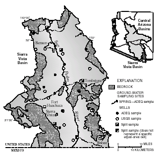 |
| National Water-Quality Assessment Program (NAWQA) of the U.S. Geological Survey and Arizona Department of Environmental Quality (ADEQ) ground-water sampling sites in the Sierra Vista Basin part of the Central Arizona Basins (CAZB). |
The assessment was based on data collected between 1971 and 1996 for 23 wells with available depth, perforation interval, and major-ion chemistry. Analyses having a cation/anion balance with a difference greater than 5 percent were not used in the assessment. The selected analyses indicated that cation content in ground water was primarily more than 50-percent calcium, and anion content was primarily more than 50-percent bicarbonate. The sulfate concentration in one analysis exceeded the U.S. Environmental Protection Agency maximum contaminant level for drinking water, and the fluoride concentration in one analysis exceeded the secondary maximum contaminant level for drinking water (U.S. Environmental Protection Agency, 1996).
The USGS and ADEQ each planned to sample 20 wells as part of the cooperative data-collection effort. To ensure that the wells chosen for sampling were randomly distributed throughout the Sierra Vista Basin, computer software (Scott, 1990) was used to subdivide the basin into 20 equal-area polygons, referred to as cells. Within each cell, primary, secondary, and tertiary points were randomly assigned by the computer software. Different sets of random points within each cell were used by the ADEQ and USGS.
Wells within approximately a 1-mile radius of each primary point were identified and randomly ordered. The wells then were visited sequentially to determine if they were suitable for sampling. If none of the wells within a 1-mile radius of the primary point were adequate, wells around the secondary point were identified and randomly ordered. A well was suitable for sampling if it had a submersible pump, a sampling point before water entered storage tanks, and a measuring point to determine depth to water; if construction information (depth, perforated interval, casing diameter, and driller's log) was available, and if the well owner gave permission to sample. The wells selected were for public, domestic, and livestock use.
The USGS followed NAWQA groundwater sampling protocols and procedures (Koterba and others, 1995) to quantify and minimize measurement bias and variability associated with the data-collection process. Quality-control samples (blanks, spikes, and replicates) were collected along with the environmental samples. The ADEQ ground-water sampling protocols and procedures for this study conformed to the Quality Assurance Project Plan (Arizona Department of Environmental Quality, 1991) and the Field Manual For Water Quality Sampling (Arizona Water Resources Research Center, 1995).
Both agencies planned to collect additional quality-control samples, referred to as “split samples,” at a subset of wells. The split-sample well locations were to be selected by the ADEQ and represent ADEQ equal-area cells. NAWQA groundwater sampling protocols and procedures were to be followed by ADEQ and USGS for most of the split samples; and one split sample was to be collected with each agency following their respective protocols to determine if a difference was detectable.
The USGS sampled one well in 19 of the 20 cells; no suitable well was found in one cell in the northeastern corner of the basin. ADEQ also sampled a well in each of the 19 cells; a spring was sampled in the cell where no suitable well was available.
Split samples were collected by the USGS and ADEQ at 6 of the ADEQ’s 19 wells. An additional split sample was collected at a well not used to represent a specific equal-area cell.
Ground water from each well was analyzed for a large number of chemical constituents and physical properties (see table). Chemical analyses included as part of both agencies’ programs were performed on split samples. Samples collected by the USGS were analyzed by the USGS National Water-Quality Laboratory in Arvada, Colorado. Samples collected by the ADEQ were analyzed by the Arizona Department of Health Services Laboratory in Phoenix, Arizona.
| Analyses completed in
Sierra Vista Basin during cooperative data-collection effort [— , not analyzed for] |
|||||
|
|
|||||
| USGS | ADEQ | Split samples | |||
|---|---|---|---|---|---|
|
|
|||||
| Major ions | Major ions | Major ions | |||
| Trace elements | Trace elements | Trace elements | |||
| Nutrients | Nutrients | Nutrients | |||
| Volatile organic compounds |
— | — | |||
| Dissolved organic carbon | — | — | |||
| Pesticides | — | — | |||
| Radon | — | — | |||
| Isotopes of hydrogen and oxygen |
— | — | |||
| Field parameters (pH, |
Field parameters (pH, | Field parameters (pH, | |||
| dissolved oxygen, | specific conductance, | specific conductance, | |||
| specific conductance, | temperature) | temperature) | |||
| temperature, turbidity, | |||||
| alkalinity, acid- | |||||
| neutralization | |||||
| capacity) | |||||
This Federal-State effort allowed the USGS and ADEQ to collect more data than either agency could have collected alone. These additional data will result in comprehensive findings that will benefit both participating agencies and the general public.
—Alissa Coes and Dorinda Gellenbeck (USGS), and Doug Towne (ADEQ)
Arizona Department of Environmental Quality, 1991, Quality assurance project plan: Phoenix, Arizona, Arizona Department of Environmental Quality, Water Quality Standards Unit, 209 p.
—1995, Arizona laws relating to environmental quality: Charlottesville, Virginia, Michie Company, 200 p.
Arizona Water Resources Research Center, 1995, Field manual for water-quality sampling: Tucson, Arizona, University of Arizona College of Agriculture, 51 p.
Gilliom, R.J., Alley, W.M., and Gurtz, M.E., 1995, Design of the National Water-Quality Assessment Program—Occurrence and distribution of water-quality conditions: U.S. Geological Survey Circular 1112, 33 p.
Koterba, M.T., Wilde, F.D., and Lapham, W.W., 1995, Ground-water data-collection protocols and procedures for the National Water-Quality Assessment Program—Collection and documentation of water-quality samples and related data: U.S. Geological Survey Open-File Report 95–399, 113 p.
Scott, J.C., 1990, Computerized stratified random site-selection approaches for design of a groundwater- quality sampling network: U.S. Geological Survey Water-Resources Investigations Report 90–4101, 109 p.
U.S. Environmental Protection Agency, 1996, National primary drinking water regulations: U.S. Code of Federal Regulations, Title 40, Parts 141 and 143, revised as of July 1, 1996, p. p. 288–429 and p. 470– 473.
For more information contact:
| AccessibilityFOIAPrivacyPolicies and Notices | |
 |
|