Geohydrology of the Idaho National Engineering and Environmental Laboratory, Eastern Snake River Plain, IdahoIndex of Subjects
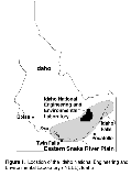
BACKGROUNDIn 1949, the U.S. Atomic Energy Commission, which later became the U.S. Department of Energy, requested that the U.S. Geological Survey (USGS) describe the water resources of the area now known as the Idaho National Engineering and Environmental Laboratory (INEEL) (fig. 1). The purpose of the result-ing study was to characterize these resources before the development of nuclear-reactor testing facilities. The USGS since has maintained a monitoring network at the INEEL to determine hydrologic trends and to delineate the movement of facility-related radiochemical and chemical wastes in the Snake River Plain aquifer. This fact sheet, summarized from two published reports (Anderson and others, 1996; Bartholomay and others, 1997), describes the geohydrology of the eastern Snake River Plain (fig. 1) at the INEEL.
RECHARGEThe Snake River Plain aquifer is one of the most productive aquifers in the United States (U.S. Geological Survey, 1985, p. 193). Recharge to the Snake River Plain aquifer is principally from infiltration of applied irrigation water, infiltration of streamflow, and ground-water inflow from adjoining mountain drainage basins. Some recharge may be from direct infiltration of precipitation, although the small amount of annual precipitation on the plain (8 inches at the INEEL), evapotranspiration, and the great depth to water (in places exceeding 900 feet) probably minimize this source of recharge.
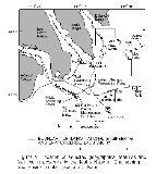
The average streamflow in the Big Lost River below Mackay Reservoir (fig. 2) for the 79-year period of record (water years 1905, 1913-14, and 1920-95) was 222,900 acre-feet per year (Brennan and others, 1996, p. 217). During 1992-95, streamflow in the Big Lost River below Mackay Reservoir ranged from 125,900 acre-feet (56 percent of average flow) during the 1992 water year (Harenberg and others, 1993, p. 178) to 310,000 acre-feet (139 percent of average flow) during the 1995 water year (Brennan and others, 1996, p. 217). Streamflow recorded for the Big Lost River near Arco during 1993 and 1995 was 10,610 and 84,880 acre-feet per year, respectively. Before 1989, recharge to the Snake River Plain aquifer downstream from Arco was substantial because of infiltration of streamflow from the Big Lost River channel, diversion areas, sinks, and playas. For example, measured infiltration losses at various discharges ranged from 1 to 28 cubic feet per second per mile (Bennett, 1990, p. 1). Combined discharge in the Big Lost River below the INEEL diversion near Arco and the INEEL diversion at its head near Arco was 7,777 acre-feet per year in 1993 (Harenberg and others, 1994, p. 210, 212) and 80,080 acre-feet per year in 1995 (Brennan and others, 1996, p. 221, 223). No streamflow occurred in the Big Lost River downstream from Arco during 1992 and 1994.
GEOLOGIC FRAMEWORK OF THE SNAKE RIVER PLAIN AQUIFERThe Snake River Plain aquifer consists of a thick sequence of basalts and sedimentary interbeds filling a large, arcuate, structural basin about 200 miles long and 50 to 70 miles wide in southeastern Idaho. The INEEL is on the west-central part of the eastern Snake River Plain. The INEEL is underlain by hundreds of basalt flows, basalt-flow groups, and sedimentary interbeds; basalt makes up about 90 percent of the volume of deposits in the unsaturated zone and the aquifer in most areas. A basalt flow is a solidified body of rock that was formed by a lateral, surficial outpouring of molten lava from a vent or fissure (Bates and Jackson, 1980). A basalt-flow group consists of one or more distinct basalt flows deposited during a single eruptive event (Kuntz and others, 1980). All basalt flows of each group erupted from the same vent or vents and have similar ages, paleomagnetic properties, potassium contents, and natural-gamma emissions (Anderson and Bartholomay, 1995). The basalt flows, which locally are altered (Fromm and others, 1994), consist mainly of medium- to dark-gray vesicular to dense olivine basalt. Individual flows are as much as 100 feet thick and in places are interbedded with cinders and thin layers of sediment. Sedimentary interbeds, which are most abundant between flow groups, accumulated on the ancestral land surface for hundreds to hundreds of thousands of years during periods of volcanic quiescence. Sedimentary interbeds are as much as 50 feet thick and consist of well to poorly sorted deposits of clay, silt, sand, and gravel. In places the interbeds contain cinders and basalt rubble.
GROUND-WATER FLOWThe basalt and sediment underlying the INEEL are saturated at depth and together form the Snake River Plain aquifer. Depth to water at the INEEL ranges from about 200 feet below land surface in the northern part to about 900 feet in the southern part (Ott and others, 1992); the general direction of ground-water flow is northeast to southwest at an average hydraulic gradient of about 4 feet per mile. The effective base of the aquifer at the INEEL generally coincides with the top of a thick and widespread layer of clay, silt, sand, and altered basalt that is older than about 1.6 million years (Anderson and Bowers, 1995). The top of this layer ranges in depth from 815 to 1,710 feet below land surface in the western half of the INEEL. The effective saturated thickness of the aquifer ranges from about 600 feet near Test Area North to about 1,200 feet near the Idaho Chemical Processing Plant and the Radio-active Waste Management Complex (fig. 2). Saturated thickness in the eastern half of the INEEL may be greater than 1,200 feet. Hydraulic properties of the aquifer differ considerably from place to place depending on saturated thickness and the character-istics of the basalt and sediment. In places, the basalt and sediment in the uppermost part of the aquifer yield thousands of gallons per minute of water to wells, with negligible drawdown (Ackerman, 1991). Hydraulic data for the basalt, sediment, ash, and tuff underlying the aquifer are sparse, but data from a deep test well indicate that these deposits are relatively impermeable compared with the aquifer (Mann, 1986). Localized zones of perched ground water, which are attributed mainly to infiltration of water from unlined percolation ponds and recharge from the Big Lost River, are present in basalt and sediment overlying the Snake River Plain aquifer (Cecil and others, 1991).Water in the Snake River Plain aquifer moves prin-cipally through fractures and interflow zones in the basalt. A significant proportion of the ground water moves through the upper 200 to 800 feet of basaltic rocks (Mann, 1986, p. 21). Ackerman (1991, p. 30) reported a range of transmissivity of basalt in the upper part of the aquifer from 1.1 to 760,000 feet2 per day. The hydraulic conductivity of underlying rocks is 0.002 to 0.03 feet per day, several orders of magnitude smaller (Mann, 1986, p. 21). Ground water moves southwestward from the INEEL and eventually is discharged to springs along the Snake River downstream from Twin Falls, 100 miles southwest of the INEEL. About 3.7 million acre-feet of ground water was discharged to these springs in 1995.
REFERENCES CITEDAckerman, D.J., 1991, Transmissivity of the Snake River Plain aquifer at the Idaho National Engineering Laboratory, Idaho: U.S. Geological Survey Water-Resources Investigations Report 914058 (DOE/ID-22097), 35 p.Anderson, S.R., Ackerman, Daniel J., Liszewski, M.J., and Freiburger, R.M., 1996, Stratigraphic data for wells at and near the Idaho National Engineering Laboratory, Idaho: U.S. Geological Survey Open-File Report 96-248 (DOE/ID-22127), 27 p. and 1 diskette. Anderson, S.R., and Bartholomay, R.C., 1995, Use of natural-gamma logs and cores for determining stratigraphic relations of basalt and sediment at the Radioactive Waste Management Complex, Idaho National Engineering Laboratory, Idaho: Journal of the Idaho Academy of Science, v. 31, no. 1, p. 1-10. Anderson, S.R., and Bowers, Beverly, 1995, Stratigraphy of the unsaturated zone and uppermost part of the Snake River Plain aquifer at Test Area North, Idaho National Engineering Laboratory, Idaho: U.S. Geological Survey Water-Resources Investigations Report 954130 (DOE/ID-22122), 47 p. Bartholomay, R.C., Tucker, B.J., Ackerman, D.J., and Liszewski, M.J., 1997, Hydrologic conditions and distribution of selected radiochemical and chemical constituents in water, Snake River Plain aquifer, Idaho National Engineering Laboratory, Idaho, 1992 through 1995: U.S. Geological Survey Water-Resources Investigations Report 97-4086 (DOE/ID-22137), 57 p. Bates, R.L., and Jackson, J.A., eds., 1980, Glossary of geology (2d ed.): Falls Church Va., American Geological Institute, 749 p. Bennett, C.M., 1990, Streamflow losses and ground-water level changes along the Big Lost River at the Idaho National Engineering Laboratory, Idaho: U.S. Geological Survey Water-Resources Investigations Report 904067 (DOE/ID-22091), 49 p. Brennan, T.S., O'Dell, I., Lehmann, A.K., and Tungate, A.M., 1996, Water resources data, Idaho, water year 1995-volume 1. Great Basin and Snake River Basin above King Hill: U.S. Geological Survey Water-Data Report ID-95-1, 452 p. Cecil, L.D., Orr, B.R., Norton, T., and Anderson, S.R., 1991, Formation of perched ground-water zones and concentrations of selected chemical constituents in water, Idaho National Engineering Laboratory, Idaho, 1986-88: U.S. Geological Survey Water-Resources Investigations Report 91-4166 (DOE/ID-22100), 53 p. Fromm, J.M., Hackett, W.R., and Stephens, J.D., 1994, Primary mineralogy and alteration of basalts and sediments in drillcores from the Idaho National Engineering Laboratory, eastern Snake River Plain [Abs.]: International Symposium on the Observation of the Continental Crust Through Drilling, VIIth, Santa Fe, N. Mex., April 25-30, 1994 [Abstracts], unpaginated. Harenberg, W.A., Jones, M.L., O'Dell, I., Brennan, T.S., Lehmann, A.K., and Tungate, A.M., 1993, Water resources data, Idaho, water year 1992-volume 1. Great Basin and Snake River Basin above King Hill: U.S. Geological Survey Water-Data Report ID-92-1, 377 p. -----1994, Water resources data, Idaho, water year 1993-volume 1. Great Basin and Snake River Basin above King Hill: U.S. Geological Survey Water-Data Report ID-93-1, 401 p. Kuntz, M.A., Dalrymple, G.B., Champion, D.E., and Doherty, D.J., 1980, Petrography, age, and paleomagnetism of volcanic rocks at the Radioactive Waste Management Complex, Idaho National Engineering Laboratory, Idaho, with an evaluation of potential volcanic hazards: U.S. Geological Survey Open-File Report 80-388, 63 p. Mann, L.J., 1986, Hydraulic properties of rock units and chemical quality of water for INEL1-a 10,365-foot deep test hole drilled at the Idaho National Engineering Laboratory, Idaho: U.S. Geological Survey Water-Resources Investigations Report 864020 (IDO22070), 23 p. Ott, D.S., Edwards, D.D., and Bartholomay, R.C., 1992, Water-level data for selected wells on or near the Idaho National Engineering Laboratory, Idaho, 1983 through 1990: U.S. Geological Survey Open-File Report 92643 (DOE/ID-22105), 307 p. U.S. Geological Survey, 1985, National water summary, 1984-Hydrologic events, selected water-quality trends, and ground-water resources: U.S. Geological Survey Water-Supply Paper 2275, 467 p.
|


