
This document is also available in pdf format: ![]() fs-173-97.pdf
fs-173-97.pdf
Since October 1, 1995, Arizona has been experiencing one of the driest periods on record. From October 1, 1995, to June 30, 1997, streamflow averaged 50 percent of normal for the Gila, Salt, and Verde Rivers. However, scientists are recording warm water temperatures in the eastern Pacific Ocean, which typically indicate a return of the El Nińo phenomenon. El Nińo is usually associated with increased winter rainfall and drier summers for Arizona and is closely associated with some of Arizona's wettest years (Rasmusson, 1985).
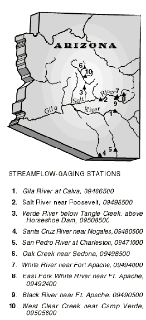
image size 58KB |
| Figure 1. Selected streamflow-gaging stations of the U.S. Geological Survey in Arizona. |
With the pronounced climate variation in the State, moisture conditions can vary from drought to flooding. Mean annual precipitation in Arizona ranges from about 4 inches in Yuma and other areas along the lower Colorado River to more than 30 inches at higher elevations in mountainous regions. Regional storm systems generate most of the precipitation and runoff in the State. These storms typically occur as frontal systems during the winter and early spring (December to April). Precipitation from frontal storms usually falls at slow to moderate rates over long periods and large areas. Isolated summer thunderstorms, or monsoon storms, occur during late summer (July to September) and provide additional precipitation that typically falls quickly in localized areas for short periods of time. Monsoon storms may cause serious flooding in places but typically provide little runoff for water supplies. Dissipating tropical cyclones or hurricanes occasionally occur during late summer and fall and may produce significant amounts of runoff but are less frequent than other types of storms. Consequently, runoff produced by precipitation from frontal-storm systems generally is the main source of water for replenishment of the reservoirs in central Arizona. From October 1, 1995, to June 30, 1997, precipitation averaged below normal at four selected sites in various areas of the State.
Precipitation records from the four sites—Flagstaff Airport, Sedona Ranger Station, Payson, and McNary 2N—show that precipitation from October 1995 through June 1997 was 46, 48, 75, and 70 percent of normal, respectively (National Oceanic and Atmospheric Administration, 1996, 1997). These precipitation stations are at or near the headwaters of major rivers. Although frontal-storm precipitation and subsequent snowpack increased during the winter and spring of 1997 (December 1996 through April 1997) as compared with the same period in 1995-96, precipitation for the four stations was still 55, 69, 82, and 64 percent of normal, respectively, for December 1996 through April 1997. Some areas of the State did receive substantial monsoonal rainfall during the late summer of 1996, but these storms typically were localized and of short duration and resulted in little runoff to replenish reservoir systems.
Even though streamflow rates have increased in 1997 compared to 1996, the average amount of water flowing in the major river systems of central Arizona still remains below normal. One way to compare streamflow conditions of 1996 to 1997 is to look at the total volume of water at streamflow-gaging stations for the months December through April, which usually produce the most streamflow. Water volume commonly is measured in acre-feet. One acre-foot is equivalent to the volume of water covering 1 acre to a depth of 1 foot (325,851 gallons) and is commonly considered to be the average amount of water used by a household of four in one year. Normal volumes of streamflow for the Gila River at Calva, Salt River near Roosevelt, and Verde River below Tangle Creek are 192,200, 448,600, and 318,600 acre-feet, respectively, for December through April for the periods of record (table 1). At the gaging station, Gila River at Calva, 28,940 acre-feet of water flowed from December 1995 to April 1996 compared with 127,900 acre-feet for the same period in 1996-97. At the gaging station, Salt River near Roosevelt, 66,060 acre-feet flowed during December 1995 through April 1996 compared with 277,600 acre-feet during this period in 1996-97. For the gaging station, Verde River below Tangle Creek, 76,520 acre-feet of water flowed between December 1995 and April 1996 compared with 159,200 acre-feet for this period in 1996-97.
From October 1, 1995, through June 30, 1997, runoff recorded at streamflow-gaging stations, Gila River at Calva (09466500), Salt River near Roosevelt (09498500), and Verde River below Tangle Creek (09508500) were 48, 43, and 45 percent of normal, respectively, as compared with mean monthly flows for the period of record (POR) for each site (table 1 and fig. 2).
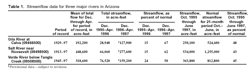 |
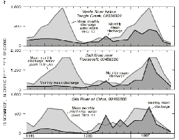
image size 58KB |
| Figure 2. Monthly mean discharge for October 1, 1995, to June 30, 1997, and the mean-monthly discharge for the period of record at Verde River below Tangle Creek, Salt River near Roosevelt, and Gila River at Calva (data for 1997 are provisional and are subject to revision). |
Below-normal precipitation conditions for October 1, 1995, to September 30, 1996, are shown by the number of record lows for yearly runoff for some of the major tributaries to the Salt, Verde, and Gila Rivers. These sites include the Santa Cruz River near Nogales (09480500, POR=67 years), San Pedro River at Charleston (09471000, POR=31 years), Oak Creek near Sedona (09504420, POR=15 years), White River near Fort Apache (09494000, POR=40 years), East Fork White River near Fort Apache (09492400, POR=39 years), Black River near Fort Apache (09490500, POR = 43 years), and West Clear Creek near Camp Verde (09505800, POR=32 years) (fig.1). All of the above rivers and streams, except the Santa Cruz and San Pedro Rivers, originate in either the White Mountains or the Mogollon Rim area, where runoff results primarily from frontal storms and snowmelt. Streamflow can be made up of both surface-water runoff from precipitation and inputs from ground water. Although most of the total flow in these streams originates at springs and other ground-water sources, the record low flows in 1996 resulted from extremely low runoff (Baynham and Phillips, 1996).
The U.S. Geological Survey (USGS) operates a network of 234 streamflow-gaging stations throughout the State. Most of these stations are operated with at least partial support from more than 20 other Federal, State, and local agencies. At 124 of these stations, the data recorded by the gaging stations are relayed by satellite telemetry to the USGS offices in Flagstaff, Tempe, Tucson, and Yuma. The advanced satellite-telemetry technology provides the USGS, cooperating agencies, and the public with streamflow conditions on a near real-time basis. These data are required to adequately monitor and manage the State's water supply, especially during extreme hydrologic conditions, such as floods and droughts. Streamflow data and other hydrologic information are available on the Internet through the Arizona District home page at http://wwwdaztcn.wr.usgs.gov.
—Owen R. Baynham, Joseph P. Capesius, and Jeff V. Phillips
Baynham, O.R., and Phillips, J.V., 1996, Precipitation and streamflow conditions in Arizona, winter and spring, 1996: U.S. Geological Survey Fact Sheet FS-223-96, 1 sheet.
National Oceanic and Atmospheric Administration, 1996, Climatological data, annual summary—Arizona, 1995: Ashville, North Carolina, National Climatic Data Center, v. 99, no. 13.
------1997, Climatological data, annual summary—Arizona, 1996: Ashville, North Carolina, National Climatic Data Center, v. 100, no. 13.
Rasmusson, E.M., 1985, El Nińo and variations in climate: American Scientist, v. 73, p. 168-177.
Smith, C.F., Duet, N.R., Fisk, G.G., McCormack, H.F., Partin, C.K., Pope, G.L., and Rigas, P.D., 1996, Water-resources data, Arizona, water year 1996: U.S. Geological Survey Water-Data Report AZ-96-1, 328 p.
For more information contact:
U.S. Geological Survey
520 N. Park Ave., Suite 221
Tucson, Arizona 85719-5035
(520) 670-6671
| AccessibilityFOIAPrivacyPolicies and Notices | |
 |
|