
|
|
|
|
|
"The U.S. Geological Survey (USGS) has worked in Antarctica for nearly 50 years, starting in 1947 with geophysical and geologic surveys and in 1957 with topographic mapping. Today the USGS also does marine, airborne, and satellite studies, as well as mapping and coring of the ice sheet, as part of the U.S. Antarctic Program. USGS scientific leadership is a cornerstone for international Antarctic cooperation, and data and information gathered by USGS researchers are important to the development of U.S. policy regarding the Antarctic." Understanding global climate change means understanding the geological and glacial histories of Antarctica.
U.S. Geological Survey (USGS) scientists have actively conducted basic research in the Antarctic region for many years.Since 1947, USGS investigators have conducted geologic mapping as well as onshore and offshore geophysical surveys to study the Antarctic Ice Sheet and the underlying structure of the continent and adjacent ocean basins. Scientists have conducted research in Antarctica since the late 1950's and are currently using oversnow vehicles, aircraft, ships, and satellites to help in conducting their studies. From this data, regional geophysical maps, Earth-structure profiles, maps of Antarctic ice sheets, science reports, and computer-based data files are produced and made available to anyone who wants or needs the data. These geoscience products give a solid scientific framework within which we can better understand and manage one of our last remaining frontiers on Earth: Antarctica. The USGS conducts cooperative research with other Federal agencies and academia.The USGS works closely with all U.S. science agencies working in Antarctica. The Office of Polar Programs of the (U.S.) National Science Foundation (NSF) provides financial and logistic support for Antarctic activities to USGS, academic, and other groups for short-term basic research projects. USGS projects complement NSF studies with long-term mission-oriented basic research conducted in concert with NSF and academia. The USGS is able to provide qualified research scientists to collect, curate, disseminate, and interpret large geoscience data bases using state-of-the-art technology. USGS scientists are currently involved in several projects in Antarctica. Studies underway include over-ice seismic reflection profiling of the Wilkes Basin, conducted with Victoria University in New Zealand; aerogeophysical surveying of the West Antarctic Ice Sheet, Byrd Basin, and the Transantarctic Mountains, flown with Lamont Doherty Earth Observatory, University of Texas, and Bundesanstalt fur Geowissenschaften und Rohstoffe (BGR) in Germany; marine crustal-profiling of the boundary between East and West Antarctica in the Ross Sea, in cooperation with Italy's Osservatorio Geofisico Sperimentale and BGR; ice coring at Taylor Dome to support global climate change studies; and satellite imagery to study fluctuation and dynamics of the Antarctic Ice Sheet. The USGS operates an ice-core facility in Colorado where all Antarctic ice cores are archived for research purposes.
USGS scientists lead and participate in international projects and policy discussions on Antarctica.
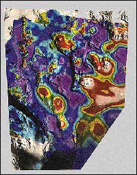
The first of these is the Antarctic Offshore Acoustic Stratigraphy Project. This project coordinates and promotes use of all existing offshore geoscience data from the continental margins around Antarctica. These data were collected to study geologic processes related to Antarctic glacial history and global sea-level changes over the past 60 million years. Over the past five years, USGS and international scientists have mapped offshore areas as large as those around the United States and have found evidence that massive grounded ice sheets have crossed the continental shelves of Antarctica many times. These crossings have been more numerous during the last 10 million years than previously. With each crossing, vast amounts of sediment and rock are carried to the edge of the continental shelf, dumped into the ocean basins, and distributed by extensive deep ocean currents. The nature of these sediments provides valuable information on the climate, sea-levels, biota, and ocean circulation of the Antarctic region. The second is a library system for Antarctic seismic reflection data; a key tool for mapping earth structures, especially in offshore areas. The library, which was designed and implemented by the USGS, has branches in the United States and in the 10 other countries that have recorded Antarctic seismic data. The data are distributed on CD-ROM for use in cooperative research studies. USGS scientists also have provided expert advice in developing the non-ratified Convention on Regulation of Antarctic Mineral Resources Activities, the new Antarctic Environmental Protocol, and several Antarctic protected areas. USGS researchers have gained new insights into the evolution of the West Antarctic Rift and Antarctic Ice Sheet.Researchers working on plate tectonic reconstructions have long suspected the presence of a plate boundary beneath the West Antarctic Rift separating East and West Antarctica. Although evidence suggests that extensive volcanism is associated with the Rift beneath the ice and sea, the effect of this rifting on global sea-levels and climate remains an issue of scientific interest and public concern. The recent discovery of a volcano beneath the West Antarctic Ice Sheet by scientists from the USGS and cooperating institutions is of considerable interest because it indicates a broad regional heating, allowing ice to move more easily. Collapse of the West Antarctic Ice Sheet would lead to accelerated melting and a rapid rise in sea level. Other recent USGS studies provide new insights to the history of Antarctic ice sheets.Mountains bordering the West Antarctic Rift may have caused the development and subsequent fluctuations of the East Antarctic Ice Sheet, which is the largest ice sheet in the world. The stability of this ice sheet profoundly affects sea level and global climate. Although the East Antarctic Ice Sheet is estimated to be stable within a range of 10,000-100,000 years (a short time frame in geologic terms), its collapse would raise sea level by over 200 feet. On a much smaller scale, melting of the West Antarctic Ice Sheet would raise sea levels by about 20 feet, but this ice sheet may be stable over only hundreds to thousands of years.
|
Related Publications: Aeromagnetic Evidence for a Volcanic Caldera(?) Complex Beneath the Divide of the West Antarctic Ice Sheet
USGS Collaborates with British Antarctic Survey
Coastal-Change and Glaciological Maps of the Antarctic Peninsula - USGS Fact Sheet 017-02 Related Links:
Scientific Committee on Antarctic Research
Office of Polar Programs United States Antarctic Program |