Link to USGS home page Link to USGS home page
Coastal and Marine Geology Program
Coastal and Marine Geology Program > Lake Baikal - A Touchstone for Global Change and Rift Studies

Lake Baikal - A Touchstone for Global Change and Rift Studies

USGS Fact Sheet

"The Lake Baikal rift system is a modern analogue for formation of ancient Atlantic-type continental margins. It tells us the first chapter in the story of how continents separate and ultimately develop into ocean basins like the Atlantic Ocean."

- Dr. Deborah Hutchinson, U.S. Geological Survey

"Lake Baikal is a unique, nearly pristine environment for the study of global change. Nowhere else in the world can we go to study so long a record of such an important, but little known, part of the global climate system."

- Dr. Steve Colman, U.S. Geological Survey

The special environmental and geological settings of Lake Baikal provide unparalleled opportunities for research and for international cooperation.

Map showing location of Lake Baikal and associated rift basins.
Map showing location of Lake Baikal and associated rift basins. [larger version]
Lake Baikal is to Russia what the Grand Canyon is to the United States: a magnificent natural resource that instills national pride and awe. The Presidents of the United States and the Russian Federation recognized the uniqueness of Lake Baikal. In a recent Joint Statement, they affirm the need to conserve the environment of Lake Baikal and to use its potential for research in limnology, geology, and global climate change. The U.S. Geological Survey's (USGS) Office of Energy and Marine Geology and Office of International Geology, supported by the Coastal Geology Program and the Global Change and Climate History Program, are involved in broad collaborative programs to study Lake Baikal with the Russian Academy of Sciences and with a number of American universities through the (U.S.) National Science Foundation.

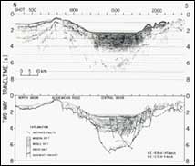
Understanding the origin of the Lake Baikal rift contributes to understanding one of the fundamental phenomena by which the history of the Earth is reconstructed.

Continental rifts, like the Lake Baikal rift, and their end products, such as passive continental margins like the east coast of the United States, are ubiquitous in the Earth's geologic record. They contain information from which a significant amount of the Earth's history has been interpreted. Due to their high sedimentation rates, large rift lakes like Lake Baikal have great potential for providing high-resolution information about both tectonic and climatic change. Significantly, sedimentary deposits of continental rifts are also associated with many of the Earth's hydrocarbon and mineral deposits.

USGS and Russian cooperative studies have begun to resolve the three-dimensional geometry of the Lake Baikal rift.

Multichannel seismic reflection line accross central part of Lake Baikal showing seismic data (top) and interpretation (bottom) Picture of R.V. Vereshchagin docked on central Lake Baikal
Multichannel seismic reflection line across central part of Lake Baikal showing seismic data (top) and interpretation (bottom). The thickest deposits are confined to a narrow trough that is 15 to 20 kilometers (9 to 12 miles) wide. [larger version] The R.V. Vereshchagin, a coring and high-resolution seismic vessel, docked on central Lake Baikal. [larger version]

Sediments of Lake Baikal reach thicknesses in excess of 7 kilometers (4 miles), and the rift floor is perhaps 8 to 9 kilometers (more than 5 miles) deep, making it one of the deepest active rifts on Earth. The shallowest sediments may contain the only known freshwater occurrence of natural gas hydrates. Maps of complex fault patterns and changing depositional environments provide the first opportunities to describe the development of the lake and to help explain its unique flora and fauna.

Unique characteristics of the Lake Baikal environment combine to produce an especially promising site for studies of climate history.

Ice-based drilling rig being tested on a small marginal lake in North Baikal.
Ice-based drilling rig being tested on a small marginal lake in North Baikal. Photo by D. Williams. [larger version]
Lake Baikal is the largest freshwater lake on Earth containing 23,000 cubic kilometers of water, or roughly 20 percent of the world's total surface fresh water. It contains as much fresh water as the Great Lakes of North America combined. At over 1,600 meters (5250 feet), it is the deepest lake in the world, and at perhaps more than 25 million years old, the oldest as well. The water of Lake Baikal is so fresh that calcium carbonate does not survive in the fossil record. Despite the lake's great depth, its water is well-oxygenated throughout creating unique biological habitats.

The high latitude of Lake Baikal makes it particularly sensitive to climatic variations.

Climate variations, including those resulting from atmospheric accumulation of carbon dioxide, are more pronounced at higher latitudes. Although the lake contains a record of glaciation of surrounding mountains in its sediments, it is unique among large, high-latitude lakes in that its sediments have not been scoured by overriding continental ice sheets.

United States and Russian studies of sediment cores taken from Lake Baikal provide a detailed record of climatic variation over the past 250,000 years.

Much attention is focused on numerical models of climate change but there have been few means for reliably testing or modifying boundary conditions of general circulation models. Studies of sedimentary environments in Lake Baikal provide important opportunities to establish ground truth for general circulation models. Very little data exist for long-term climate change from continental interiors; most of the data record derives from the marine or maritime environments. Finally, studies of past environments contribute to understanding the extent to which human activity affects natural conditions in the lake.

Graph showing percentages of biogenic silica in two Lake Baikal cores. Graph showing percentages of biogenic silica in two Lake Baikal cores. Since diatoms and algae are the most important microorganisms in the lake, biogenic silica is a measure of primary productivity. Radiocarbon ages in years are shown by arrows. First-order changes are caused by glacial (blue)-interglacial (red) cycles, with transitions shown in purple. Second-order fluctuations, such as the peak at 3,770 years, are due to shorter climatic events. [larger version]

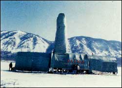
Seismic and sediment core analyses are used to fix future drilling sites in Lake Baikal.

Ice-based drilling operations begun in early 1993 are providing longer (over 100 meters in length) cores of Baikal sediments. Analyses of these cores are expected to reveal the climatic, environmental, and geological history of the region as far back as 5 million years. Seismic data will be tied to cores and drill samples to estimate rates of climate change and to map the history of the lake and rift. Very deep drilling in Lake Baikal remains technologically challenging; therefore, the deepest deposits of the rift are not likely to be sampled soon. However, the potentially very long record of sedimentation in Lake Baikal provides unique opportunities to understand the Cenozoic climate history of the Earth and to describe how continents begin to break apart, giving rise to new ocean basins.

Contact Information
Dr. Deborah Hutchinson
U.S. Geological Survey
384 Woods Hole Rd
Woods Hole, MA 02543
Phone: (508) 457-2263
Fax: (508) 457-2310
Email: dhutchinson@usgs.gov
Dr. Steve Colman
U.S. Geological Survey
384 Woods Hole Rd
Woods Hole, MA 02543
Phone: (508) 457-2341
Fax: (508) 457-2310
Email: scolman@usgs.gov

Related Research Projects:

Lake Baikal Paleoclimatology and Paleolimnology Project
USGS

Related Publications:

Crustal structure of central Lake Baikal: Insights into intracontinental rifting (1.5 MB PDF file)
Originally published in Journal of Geophysical Research

Related Links:

National Science Foundation

USGS Coastal and Marine Geology Program
USGS

Global Change Research
USGS


Coastal and Marine Geology Program > Lake Baikal - A Touchstone for Global Change and Rift Studies


[an error occurred while processing this directive]