
|
|
|
|
|
Changes in the position and strength of atmospheric cells over the eastern North Pacific profoundly influence the climate of western North America.
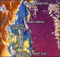
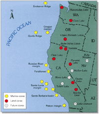
U.S. Geological Survey (USGS) scientists examine cores from marine and terrestrial environments to correlate climate events.The geological record preserved in sediments can contain a high-resolution paleoclimatic record with timelines across western North America. Such time correlations allow USGS scientists to produce regional interpretations of paleo- (or ancient) climate. USGS scientists map paleoclimatic responses to changes in oceanic and atmospheric circulation using the high-resolution data. Initial interpretations suggest that oceanic response to global glacial advances and retreats are not simple, that it cannot be described in "binary" fashion as being glacial or interglacial, and that other distinct periods mark the transition between glacial and non-glacial conditions. In addition, early evidence suggests that a short lag time of perhaps 1,000 years may exist between changes occurring in the marine environment and corresponding changes being seen on land. The implication of this suggestion, therefore, is that if we can identify contemporary changes in patterns of marine sedimentation, then these changes may augure yet-to-occur changes on land in western North America. Recent marine studies indicate that only a narrow range of oceanic conditions is conducive to preserving the annual record in cores.The oceanic oxygen-minimum zone is ideal for preservation of a very high-resolution (annual) record because the zone encourages biological activity in the water column but inhibits activity in sediments. This zone occurs at a depth of between 600 and 1,000 meters off California where living organisms consume abundant quantities of organic materials that descend through the water column from the photic zone above. In this zone, much of the available oxygen in the water column is depleted as carbon is "burned" by biological activity: hence, the term oxygen-minimum zone. In places where the seafloor intersects a strongly-developed oxygen-minimum zone, such as off central California, oxygen can become so depleted that bottom-dwelling organisms cannot survive. This preserves the fine-scale, semi-annual varves or laminations of seasonal sedimentation. These well-preserved sediments can be analyzed at a resolution of one year.
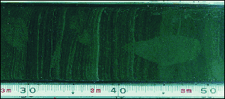
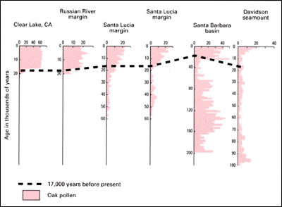
USGS studies indicate that cores reflect details of climate change and can be used as a proxy for direct measurements.A variety of useful data are available from study of sediment cores including simple physical counts and thickness measurements of visible layers. These layers, or varves, indicate periodic changes in the kinds of sediments deposited on the seafloor as a result of known changes, such as El Niño events. These layers are caused by seasonal variations and can be counted, just as tree rings are, to determine their age. The difficulty facing researchers is determining the age of the starting point, so other physical and chemical data found in the varves are measured to establish a known timeline. The most easily-recognized and correlated layers in these cores are derived from volcanic ash and from oak pollen. At present, C14 dating techniques including the margins of error, allow a resolution of about 100 years over the past 40,000 years, which is sufficient to describe large-scale climatic change.
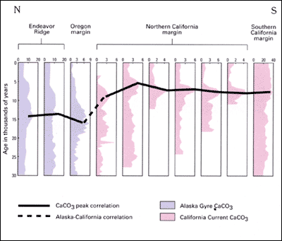
Results of recent USGS investigations suggest that a shift in climate patterns occurred over the eastern North Pacific Ocean.The concentration of material derived from skeletons of marine organisms changed dramatically, indicating that a significant oceanographic event occurred. Whatever the event, evidence suggests that it occurred at different times in the area over the eastern North Pacific Ocean. In waters affected by the Alaska Gyre off the northwest coast of North America, the event took place around 15,000 years ago. In waters affected by the California Current off central North America, the event occurred about 9,000 years ago. A key implication is that an atmospheric change caused a shift in the positions or strengths of these two ocean currents. The oceans of the world are complex environments that are sensitive to changes in the atmosphere. That USGS scientists are able to identify such changes in core sediments is an encouraging advance in validating global climate change models and in understanding global climate history as a reflection of the Earth's geological history.
|
Related Publications: Related Links: Intergovernmental Panel on Climate Change U.S. Environmental Protection Agency |