
|
|
|
|
|
"San Francisco Bay has received much scientific attention over the years primarily because of regional questions regarding water quality and, more recently, geologic hazards, but very little is known about sediment distribution and movement on the floor of the Bay. The link between sediment accumulation in the Bay and processes that produce the staggering losses of wetlands acreage and continual channel filling is becoming better understood as U.S. Geological Survey scientists undertake new research of the region." Concern about locations of disposal sites for dredge materials has raised interest in a detailed study of the Bay environment.
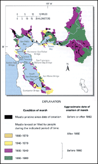
Nearly all the tidal wetlands in the San Francisco Bay region have been lost.Before 1850, the region sustained 1,400 square kilometers of freshwater wetlands and 800 square kilometers of salt marshes; today, only 125 square kilometers of undiked marshes remain of the original 2,200 square kilometers, representing a 95 percent loss of crucial habitat. This staggering loss results almost wholly from human activity, including hydraulic mining in the latter part of the 1800's and population pressures during the 1900's. The remaining 125 square kilometers of wetlands are threatened by development, erosion, pollution, and sea-level rise. USGS scientists have begun a long-term study of the evolution of wetlands. As proposed in their National Coastal Geology Plan, scientists at the USGS have begun a long-term study of wetlands, especially sediment transport to and from wetlands and patterns of sediment distribution. Results of these studies will provide insight to the nature of wetlands around San Francisco Bay, the amount of sediment reworked and moved, as well as the distribution and ultimate fate of contaminants adhering to sediments. USGS scientists also are preparing a detailed inventory of sediment type and distribution on a fine scale from which a sediment history can be determined. USGS studies indicate that the health of wetlands relates directly to the health of the Bay region.Processes that govern sediment movement directly affect the distribution of wetlands. The U.S. Fish and Wildlife Service estimates that the San Francisco Bay region is the estuarine system in the United States that has been most modified over historical time. Coastal managers are examining the efficacy of wetland restoration using available dredge spoils as fill in currently diked areas such as salt ponds. The need for healthy wetlands is well-documented and includes recognition that they foster diverse animal and plant life; they act as a buffer between human activity and a healthy estuarine environment thereby mitigating potential damage to the ecosystem; they function as a crucial nursery area for fish; and they provide a critical nesting ground and migratory transition area for many species of waterfowl.
USGS studies are part of a long-term management strategy.The Environmental Protection Agency and the U.S. Army Corps of Engineers commissioned a strategy group to study and recommend suitable disposal sites for dredge materials from the Bay. The USGS participates in the group to advise on transportation and distribution of sediments. By 1994, a well-reasoned plan will begin to be implemented for the disposal of dredge materials. At the same time, USGS investigators work cooperatively with the San Francisco Bay Conservation and Development Commission to develop mitigation strategies for wetlands preservation. USGS researchers will also evaluate the buildup of toxic metals in Bay sediments.Certain heavy metals (including bismuth, selenium, and chromium that are toxic in small quantities) have accumulated at specific sites. USGS studies in other areas indicate that contaminants attach to specific sediment types and move with them to a final resting place. Therefore, contaminant movement is largely dependent on sediment movement. Considerable effort is expended on understanding the distribution of sediment types and the dynamics of sediment movement. Results are significant for answering questions about disposal of dredge materials and restoration of wetlands. As spoils containing contaminated sediments are dredged and dumped in disposal areas, the contaminants are resuspended and can be redeposited elsewhere, whether in the marine or estuarine environments, or in wetland restoration sites.
|
Related Publications: Preliminary Geochemical Studies
of Pollutant and Natural Organic Compounds in Sediments from Sonoma Baylands - A Wetland Restoration Project in San Francisco Bay, California - USGS Open File Report 96-048 Related Links: Access USGS - San Francisco Bay and Delta Morphodynamic Conditions at the
Sonoma Baylands Restoration Site San Francisco Bay Area Regional Database (BARD) San Francisco Bay Conservation and Development Commission The U.S. Fish and Wildlife Service U.S. Environmental Protection Agency U.S. Army Corps of Engineers |