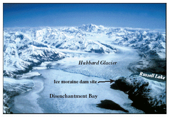
Hubbard Glacier, the largest calving glacier on the North American Continent (25 percent larger than Rhode Island), advanced across the entrance to 35-mile-long Russell Fiord (fig.1) during June 2002, temporarily turning it into a lake. Hubbard Glacier has been advancing for more than 100 years and has twice closed the entrance to Russell Fiord during the last 16 years by squeezing and pushing submarine glacial sediments across the mouth of the fiord (figs. 2 and 3). Water flowing into the cutoff fiord from mountain streams and glacier melt causes the level of Russell Lake to rise. However both the 1986 and 2002 dams failed (fig. 4) before the lake altitude rose enough for water to spill over a low pass at the far end of the fiord and enter the Situk River drainage, a world-class sport and commercial fishery near Yakutat, Alaska.
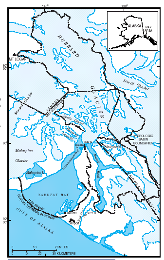 |
| Figure 1. Hubbard Glacier and Russell Fiord study area. |
Hubbard Glacier is defying the global paradigm of valley or mountain glacier shrinkage and retreat in response to global climate warming. Hubbard Glacier is the largest of eight calving glaciers in Alaska that are currently increasing in total mass and advancing. All of these glaciers calve into the sea, are at the heads of long fiords, have undergone retreats during the last 1,000 years, calve over relatively shallow submarine moraines, and have unusually small ablation areas compared to their accumulation areas.
|
Ablation: All processes by which snow and ice are lost from a glacier. Accumulation: All processes by which snow and ice are added to a glacier. |
|
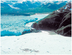
| Figure 2. Submarine glacial sediments emerging from the sea May 20, 2002. Photo by Bill Lucey, U.S. Forest Service. |
For example, Hubbard Glacier retreated about 38 miles between 1130 A.D. and late in the 19th century (fig. 1). The fiord bottom lies 1,300 feet below sea level under the glacier, shallows to a depth of 200-250 feet at the glacier calving terminus, and then deepens again to as much as 750 feet below sea level down Disenchantment Bay. The accumulation area of Hubbard Glacier is 95 percent of the entire glacier area and, like the other growing calving glaciers, is far from being in equilibrium with climate.
 |
 |
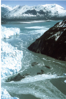
| Figure 3. Ice and moraine dam blocking the entrance to Russell Fiord, July 7, 2002. Photo by U.S. Forest Service. | Figure 4. Outburst flood on August 14, 2002, about 9 hours after Russell Lake began to lose volume. Photo by Al Grillo, Associated Press(published with permission). |
The large calving glaciers that are currently advancing have been discordant with climate-driven glacier changes for a very long time. The glaciers that are currently growing and advancing in the face of global warming were retreating throughout the Little Ice Age (AD1350 or 1450 to AD1900) when most glaciers were growing.
The 1986 closure occurred near the first of June; the 2002 closure was gradual and was complete about June 16. The newly closed Russell Lake basin filled at the average rate of 0.7 feet per day in both 1986 and 2002 (fig. 5). No water was visibly leaking through or over the dam during the 1986 closure. However, relatively small amounts of lake water overflowed the 2002 moraine dam during most of the period of closure (fig. 3). This observation suggests that the damming moraine was being squeezed higher above sea level throughout the 2002 closure period. The volume of water flowing into the lake can be calculated from the rates of lake level rise (fig. 6). During the 1986 closure, the average inflow rate was 15,000 cubic feet of water per second (ft³/s). The maximum rate of inflow was about 44,000 ft³/s, which occurred on August 13 in response to a 2-week-long rainstorm in the area. During the 2002 closure, the average net inflow rate was about 18,700 ft³/s and the maximum rate was about 92,000 ft³/s, which occurred on August 12, also in response to a rainstorm (fig. 6).
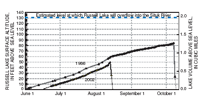 |
| Figure 5. Filling and emptying of Russell Lake during 1986 and 2002 . |
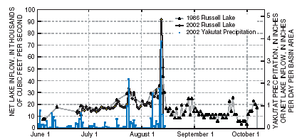 |
| Figure 6. Russell Lake filling rates and 2002 precipitation at Yakutat, Alaska. |
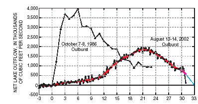
The 1986 dam failed catastrophically during the night of October 8 (fig. 7) releasing a flood that rapidly accelerated to a maximum of about 4,000,000 ft³/s about 6 hours after the initial failure (fig. 7). The 2002 dam began to fail when the lake surface altitude reached about 49 feet above sea level (fig. 5). A rainstorm caused a rapid lake rise that increased the volume of water flowing over the moraine dam, which also increased the rate of erosion of the dam. The growth of the moraine dam by glacier flow did not keep pace with erosion and the dam progressively failed (fig. 7). Dam failure released a flood that reached a maximum discharge of 1,850,000 ft³/s about 21 hours later (about midnight on August 14). These two floods are the largest recorded glacial-lake outburst flood events in historical time (table 1).
 |
| Figure 7. Russell Lake 1986 and 2002 outburst floods. |
| Table 1. Peak discharges of largest known historic glacial lake outbursts | |||
| Location | Data | Peak discharge (ft³/s) | |
|---|---|---|---|
| 1. | Russell Lake, Alaska | 1986 | 3,970,000 |
| 2. | Russell Lake, Alaska | 2002 | 1,850,000 |
| 3. | Grimsvatn, Iceland | 1934 | 1,770,000 |
| 4. | Chong Kumdan, India |
1939 | 800,000 |
| 5. | Berg Lake, Alaska | 1983 | 600,000 |
| 6. | Chakachamna Lake, Alaska | 1971 |
470,000 |
| 7. | Lake George, Alaska | 1958 | 360,000 |
| Peak discharge of Mississippi R. at Memphis, Tennessee | 1937 | 1,980,000 | |
| The maximum recorded discharge of the Mississippi River upstream from the flood-control structures on the lower river is about 7 percent larger than the maximum discharge during the 2002 outburst flood from Russell Lake and about one-half the size of the 1986 outburst flood from Russell Lake. |
Hubbard Glacier has advanced at a rate of about 80 feet per year since 1895 (fig. 8). Although the timing is uncertain, the prospect of the glacier continuing to advance and again blocking the entrance to Russell Fiord is much more certain.
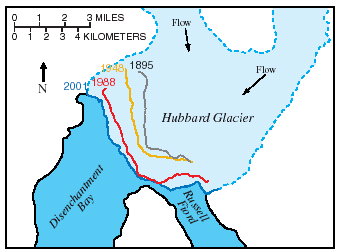 |
| Figure 8. Terminus positions of Hubbard Glacier in 1895, 1948, 1988, and 2001 showing advances over/during the last 106 years. |
 |
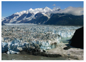
| Hubbard Glacier, June 13, 1986. Photo by Rod March, U.S. Geological Survey. |
Mayo, L.R., 1989, Advance of Hubbard Glacier and 1986 outburst of Russell Fiord, Alaska, U.S.A.: Annals of Glaciology, v. 13, p. 189-194.
Seitz, H.R., Thomas, D.S., and Tomlinson, B., 1986, The storage and release of water from a large glacier-dammed lake: Russell Lake near Yakutat, Alaska, 1986: U.S. Geological Survey Open-File Report 86–545, 10 p.
Trabant, D.C., Krimmel, R.M., and Post, A., 1991, A preliminary forecast of the advance of Hubbard Glacier and its influence on Russell Fiord, Alaska: U.S. Geological Survey Water-Resources Investigations Report 90–4172, 34 p.
U.S. Forest Service
Tongass National Forest
648 Mission Street
Federal Building
Ketchikan, AK 99901-6591 907-225-3101
http://www.fs.fed.us/r10/tongass/
National Park Service
Wrangell-St. Elias National Park and Preserve
107 Richardson Highway
P.O. Box 439 Copper Center,
AK 99573 907-822-5234
U.S. Geological Survey
4230 University Drive, Suite 201
Anchorage, AK 99508-4664
907-786-7100
U.S. Geological Survey
Glaciology
P.O. Box 75-7300
930 Koyukuk Drive
Fairbanks, AK 99775-7300
907-474-1934
http://ak.water.usgs.gov/glaciology/
| AccessibilityFOIAPrivacyPolicies and Notices | |
 |
|