 |
|
|
||||
| Fact Sheet 076–95 |
| About USGS / Science Topics / Maps, Products & Publications / Education / FAQ |
The computer programs of the Potential-Field Software Package run under the DOS operating system on IBM-compatible personal computers. They are used for the processing, display, and interpretation of potential-field geophysical data (gravity- and magnetic-field measurements) and other data sets that can be represented as grids or profiles. These programs have been developed on a variety of computer systems over a period of 25 years by the U.S. Geological Survey.
The Potential-Field Software Package is designed to take geophysical (primarily gravity-field and magnetic-field) measurements in the form of point data, flight- line data, or gridded data; process them; display them; and aid in their interpretation. Among the basic elements of the package are a forward and inverse cartographic projection routine, a minimum- curvature gridding routine, various plotting and contouring routines, Fourier and spatial filtering routines, and a graphical editing routine for spatially registered point data. More advanced elements include image generation and display routines and forward and inverse modeling routines for interpreting map and profile data.
One of the strengths of the Potential-Field Software Package lies in the common data formats used for point, flight-line, and gridded data. These standard formats have allowed a variety of scientists to write and contribute computer programs that work smoothly together. The combined expertise of these scientists has produced a software package containing algorithms at the forefront of potential-field interpretation.
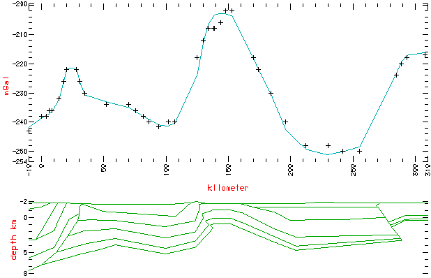
Figure - A geophysical density model (bottom) having a calculated gravity anomaly (continuous curve, top) that fits observed gravity measurements (+ symbols, top).
Additional advantages have accrued from adapting the package to run on a common and generally available platform, the IBM-compatible personal computer running under the DOS operating system. These personal computers are available in classrooms and scientific laboratories throughout the world. Their standard graphics screens, keyboards, and mouse pointers are used to great advantage for manipulating and displaying geophysical data.
A menu-driven user interface and extensive online help files are designed to aid the new user in becoming familiar with the more than 200 programs in the software package. The programs are broken into seven categories: (1) programs for displaying and generating contour maps and images, (2) programs for filtering grids, (3) utility programs for grids, (4) interpretation and modeling programs, (5) programs for gridding and manipulating point and flight-line data, (6) programs for extracting, manipulating, and interpreting profile data, and (7) miscellaneous programs.
The software package is available
on diskettes (OFR 92-18[A-G] and
OFR 93-560B) or on CD-ROM
(DDS-9) from:
USGS Information Services
Box 25286, Building 810
Denver Federal Center
Denver, Colorado 80225
(303) 202-4200
The package is also available by anonymous FTP in the pub/pf directory on musette.cr.usgs.gov
[136.177.80.14].
Click here to download.
Jeffrey D. Phillips
U.S. Geological Survey
Box 25046, MS 964
Denver Federal Center
Denver, Colorado 80225
(303) 236-1206
Fax: (303) 236-1425
EMail: jeff@usgs.gov

| AccessibilityFOIAPrivacyPolicies and Notices | |
| |
|