This report is available in pdf 513KB.
Estimates of the magnitude and frequency of flood-peak discharges and flood hydrographs are used for a variety of purposes, such as for the design of bridges, culverts, and flood-control structures; and for the management and regulation of flood plains. To provide simple methods of estimating flood peak-discharges, the U.S. Geological Survey (USGS) has developed and published equations for every State, the Commonwealth of Puerto Rico, American Samoa, and a number of metropolitan areas in the United States. In 1993, the USGS, in cooperation with the Federal Emergency Management Agency and the Federal Highway Administration, compiled all current USGS statewide and metropolitan area equations into a computer program, titled “The National Flood-Frequency (NFF) Program” (Jennings and others, 1994).
Since 1993, new or updated equations have been developed by the USGS for various areas of the Nation. These new equations have been incorporated into an updated version of the NFF Program.
This Fact Sheet describes the application of the updated NFF Program to streams that drain rural areas in Oklahoma and describes equations that can be manually applied to urban areas in Oklahoma. Information on obtaining the NFF software and fact sheets for other areas of the Nation is provided at the end of this Fact Sheet.
Tortorelli (1997) developed statewide regression equations for estimating peak discharge (QT), in cubic feet per second, for selected recurrence intervals (T) that range from 2 to 500 years for ungaged, unregulated rural streams with a contributing drainage area of less than 2,510 mi2 in Oklahoma (table 1). The report presents techniques for adjusting QT estimates computed for unregulated rural streams to estimate QT for ungaged sites on urban streams (table 2), and also presents equations for estimating peak discharge for ungaged sites on streams regulated by floodwater-retarding structures (table 3). Tortorelli (1997) also listed peak-discharge estimates and basin and climatic characteristics for the 251 streamgaging stations in Oklahoma and adjacent states that were used in the regression analyses.
Recurrence interval is the reciprocal of the annual exceedance probability and represents the average number of years between exceedances. For example, a flood-peak discharge with an exceedance probability of 0.01 has a recurrence interval of 100 years. This does not imply that the 100-year flood will be equaled or exceeded each 100 years, but that it will be equaled or exceeded on the average once every 100 years.
|
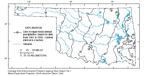
| Figure 1. Mean annual precipitation, Oklahoma. |
The equations presented in this fact sheet are based on the inch-pound system of units, but the NFF Program will accept and report either the inch-pound or metric system of units. The explanatory watershed variables used in the regression equations for estimating QT are as follow:
Drainage area (A), in square miles, is the contributing drainage area of the site of interest; noncontributing areas are not included. Drainage areas can be determined from topographic maps or by use of a Geographic Information System (GIS) and an available 1:100,000-scale digital elevation model of Oklahoma (Cederstrand and Rea, 1995)
Main-channel slope (S), in feet per mile, is computed from topographic maps by dividing the difference in elevation between points that are 10 and 85 percent of the distance along the main-channel from the location of interest to the drainage-basin divide, by the distance between those points.
Mean-annual precipitation (P), in inches, is the mean-annual precipitation for the period 1961-90 at the location of interest. P can be estimated from figure 1 or by use of a GIS and an available digital map grid of mean annual precipitation (Rea and Tortorelli, 1997).
The regression equations were developed using weighted, forward step-wise, multiple-linear regression analysis. Logarithmic transformation was used to increase linearity between the response variable (QT) and the explanatory variables. A weighting factor was computed for each station on the basis of the number of annual peak discharges for the gaged station under unregulated conditions, the length of the historical site record, and the number of high statistical outliers for the station (Tortorelli, 1997). Ultimately, the three explanatory watershed variables described above were selected, both as a result of the step-wise variable-selection procedure and because of the relative ease with which equations composed of those variables can be applied in Oklahoma.
The regression equations, the weighted standard errors of estimate, and the equivalent years of record for the equations are given in table 1. The weighted standard error of estimate is a measure of how well a regression equation fits the data used in the analysis. Errors in the regression-equation estimates of QT for about two thirds of the gaged sites used to derive the equations were within the given standard errors. Errors in the estimates of QT for ungaged sites are somewhat larger than the standard errors of estimate shown in table 1. These errors increase appreciably when the drainage area is near or beyond the range limits shown below. The equivalent years of record is the number of years of streamflow record needed to achieve the same accuracy as the regression equation.
| Table 1. Flood peak-discharge
regression equations and associated statistics for ungaged, unregulated,
rural streams in rural Oklahoma (from Tortorelli,
1997) [QT(U)r, regression estimate of peak discharge, in cubic feet per second for recurrence interval T, 2 to 500 years, U denotes ungaged (U is replaced by G when equations are used for gaged sites), r denotes rural; A, drainage area, in square miles; S, main-channel slope, in feet per mile; P, mean annual precipitation, in inches] |
||
|
|
||
| Regression Equation | Weighted standard error of estimate, in percent |
Equivalent years of record |
|---|---|---|
|
|
||
| Q2(U)r=0.075A0.615 S0.159 P2.103 | 59 | 3 |
| Q5(U)r=0.799A0.616 S0.173 P1.637 | 47 | 5 |
| Q10(U)r=2.62A0.615 S0.181 P1.404 | 45 | 8 |
| Q25(U)r=8.80A0.614 S0.190 P1.171 | 45 | 11 |
| Q50(U)r=18.6A0.614 S0.197 P1.029 | 47 | 13 |
| Q100(U)r=35.6A0.614 S0.202 P0.907 | 49 | 14 |
| Q500(U)r=126A0.612 S0.213 P0.674 | 58 | 14 |
The statewide regression equations for ungaged, unregulated streams are applicable for watersheds in Oklahoma that are not significantly affected by regulation from man-made structures. The equations are not intended for use outside Oklahoma or for conditions where one or more of the explanatory watershed variables are near or beyond the ranges of the variables for the stations used for the regression analysis. The ranges of the explanatory watershed variables that were used in the analysis were:
A — 0.144 to 2,510 mi2,
S — 1.89 to 288 ft/mi, and
P — 15.0 to 55.2 in.
The U.S. Water Resources Council (1981, appendix 8) described weighting techniques to improve estimates of peak discharge at gaged locations by combining the estimates derived from analysis of gage records with estimates derived from other means, including regression equations. The weights of the two independent estimates are based on the length of the gage record (in years) and the equivalent years of record of the applicable regression equation. The weighted estimate of peak discharge for the gaged site is computed as:
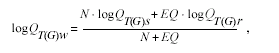
where
| QT(G)w | is the weighted estimate of discharge Q for recurrence interval T at the gaged location, |
| QT(G)s | is the estimate of QT derived from analysis of the systematic gage records, |
| QT(G)r | is the estimate of QT derived from application of the appropriate regression equation in table 1, |
| N | is the number of years in the gage record used to compute QT(G)s, and |
| EQ | is the equivalent years of record (table 1). |
The accuracy of the weighted discharge estimate, in equivalent years of record, is equal to N + EQ. The NFF Program contains an algorithm to perform these computations, which differs slightly from the computations described by Tortorelli ( 1997).
Tortorelli (1997) showed how the weighted estimates of peak discharge at a gaged site, QT(G)w, can be used to improve estimates of peak discharge at an ungaged site on the same unregulated stream that has a drainage area that is between 50 and 150 percent of the drainage area for the gaged site. The weighted estimate of peak discharge at the ungaged site, QT(U)w, is obtained by multiplying the regression estimate, QT(U)r, by an adjustment factor, AF, derived by Sauer (1974a) as follows:
where
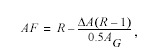
| R | is the ratio QT(G)w/QT(G)r, and |
| ΔA | is the absolute value of the difference between the drainage areas of the gaged site, AG, and the ungaged site, AU, |AG -AU| |
The regression equations should be used without adjustment when the drainage area at the ungaged site is not within 50 to 150 percent of the drainage area of the gaged site.
Flood-peak discharges for ungaged sites on urban streams can be estimated by using information on the percentage of the basin area that is impervious area and the percentage of the basin area that is served by storm sewers. These data are required in addition to the variables needed for ungaged sites on natural, unregulated streams. The percentage of the basin area that is impervious can be estimated by using aerial photographs or recent USGS topographic maps, or by doing field surveys. The percentage of the basin that is served by storm sewers should be determined from the best available storm sewer and drainage map. The percentage of the basin area that is impervious and the percentage that is served by storm sewers can be used to obtain RL, the urban adjustment factor, by using a nomogram developed by Leopold (1968) (fig. 2). The nomogram is also presented in Tortorelli (1997, fig. 4). Equations developed by Sauer (1974b), which are presented in table 2, can then be used to adjust regression-derived peak-discharge estimates for ungaged, unregulated streams, QT(U)r, to obtain peak-discharge estimates for urban settings (UT).
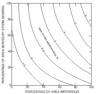 |
| Figure 2. Relationship of urban adjustment factor, RL, to the percentage of the area impervious, and area served by storm sewer. |
The equations to adjust the rural regression estimates for urban settings are not included in the NFF software. The equations can be solved manually after obtaining rural regression estimates from the NFF software, or the Sauer and others (1983) national urban equations included in the NFF software can be used instead.
|
Table 2. Equations for adjusting regression-derived
estimates of flood peak discharge for unregulated streams in rural Oklahoma
to obtain estimates of flood peak discharge for urban streams (from
Tortorelli, 1997). |
|
|
|
|
| U2= | RL Q2(U)r |
| U5= | 1.60 (RL-1) Q2(U)r+ 0.167 (7-RL) Q5(U)r |
| U10= | 1.87 (RL-1) Q2(U)r + 0.167 (7-RL) Q10(U)r |
| U25= | 2.21 (RL-1) Q2(U)r + 0.167 (7-RL) Q25(U)r |
| U50= | 2.46 (RL-1) Q2(U)r + 0.167 (7-RL) Q50(U)r |
| U100= | 2.72 (RL-1) Q2(U)r + 0.167 (7-RL) Q100(U)r |
| U500= | 3.30 (RL-1) Q2(U)r + 0.167 (7-RL) Q500(U)r |
|
|
|
Flood-peak discharges for many Oklahoma streams are regulated by floodwater-retarding structures. Many of these structures are small- to medium-sized dams. The structures, of which about 2,100 existed in 1997, are designed for up to 12,500 acre-ft of floodwater detention and have drainage areas that generally range from 1 to 20 mi2. The main effect of floodwater-retarding structures on a watershed streamflow hydrograph at a point downstream from the structures is that flood-peak discharge is reduced, and this reduction is related to the percentage of the basin that is regulated. Tortorelli (1997) showed how regression estimates for ungaged sites on regulated streams can be computed from the rural regression equations (table 1) by substituting for A the contributing drainage area of the basin that is downstream from the floodwater-retarding structure. This method for estimating flood-peak discharges on regulated streams is not applicable for watersheds in which floodwater-retarding structures regulate more than 86 percent of the drainage area.
|
Table 3. Equations for estimating flood peak
discharge for sites in Oklahoma that are affected by floodwater-retarding
structures (from Tortorelli, 1997). |
|
| F2= | 0.075Ac0.615S0.159P2.103 |
| F5= | 0.799Ac0.616S0.173P1.637 |
| F10= | 2.62Ac0.615S0.181P1.404 |
| F25= | 8.80Ac0.614S0.190P1.171 |
| F50= | 18.6Ac0.614S0.197P1.029 |
| F100= | 35.6Ac0.614S0.202P0.907 |
| F500= | 126Ac0.612S0.213P0.674 |
Cederstrand, J.T.,and Rea, Alan, 1995, Watershed boundaries and digital elevation model of Oklahoma derived from 1:100,000-scale digital topo- graphic maps: U.S. Geological Survey Water-Resources Investigations Report 95-727, CD-ROM.
Jennings, M.E., Thomas, W.O., Jr., and Riggs, H.C., comps., 1994, Nationwide summary of U.S. Geological Survey regional regression equations for estimating magnitude and frequency of floods for ungaged sites, 1993: U.S. Geological Survey Water-Resources Investigations Report 94–4002, 196 p.
Leopold, L.B., 1968, Hydrology for urban land planning - A guidebook on the hydrologic effects of urban land use: U.S. Geological Survey Circular 554, 18 p.
Rea, Alan, and Tortorelli, R.L., 1997, Digital-map grids for 1961-90, and generalized skew coefficients of annual maximum streamflow for Oklahoma, U.S. Geological Survey Open-File Report 97-574, CD-ROM.
Sauer, V.B., Thomas, W.O., Jr., Stricker, V.A., and Wilson, K.V., 1983, Flood characteristics of urban watersheds in the United States: U.S. Geological Survey Water-Suppy Paper 2207, 62 p.
Sauer, V.B., 1974a, Flood characteristics of Oklahoma streams: U.S. Geological Survey Water-Resources Investigations Report 52-73, 301 p.
Sauer, V.B.,1974b, An approach to estimating flood frequency for urban areas in Oklahoma: U.S. Geological Survey Water-Resources Investigations Report 23-74, 10 p.
Tortorelli, R.L., 1997, Techniques for estimating peak-streamflow frequency for unregulated streams and streams regulated by small floodwater-retarding structures in Oklahoma: U.S. Geological Survey Water-Resources Investigations Report 97-4202, 39 p.
U.S. Water Resources Council, 1981, Guidelines for determining flood flow frequency: U.S. Water Resources Council Bulletin 17B, 28p. 14 appendixes.
For more information contact:
U.S. Geological Survey
Office of Surface Water
415 National Center
Reston, Virginia 20192
(703) 648-5301
USGS hydrologic analysis software is available for electronic retrieval through
the World Wide Web (WWW) at :
http://water.usgs.gov/software/
and through anonymous File Transfer Protocol (FTP) from water.usgs.gov (directory:
/pub/software).
The WWW page and anonymous FTP directory from which the National Flood-Frequency
software and user documentation can be retrieved are http://water.usgs.gov/software/nff.html
and /pub/software/surface_water/nff,
respectively.
Additional earth science information is available from the USGS through the
WWW at http://www.usgs.gov/ or by calling
1-888-ASK-USGS.
| AccessibilityFOIAPrivacyPolicies and Notices | |
 |
|