
|
September 1999 The entire USGS Fact Sheet FS-145-99 can be successfully viewed or downloaded (4 MB), for use with Adobe Acrobat Reader (version 3.0 or later). If you do not already have Acrobat Reader version 3.0 or later, you may download the latest version here. |
|
|
Federally Owned Coal and Federal Lands in the Colorado Plateau Region |
|
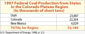
Federally
owned coal plays a major role in the energy supply of the United States.
About 1.1 billion tons of coal were produced in the United States in 1997
(U.S. Department of Energy, 1998). About 30 percent of that total, or about
330 million tons, came from Federal lands. (See USGS Fact Sheet FS-012-98,
http://greenwood.cr.usgs.gov/pub/fact-sheets/fs-0012-98/.) Almost all of
the Federal coal production is from Wyoming, Montana, and three States
in the Colorado Plateau RegionUtah, Colorado, and New Mexico1
(see table below).
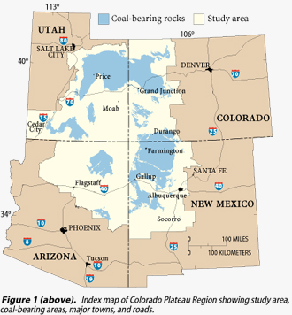
The National Coal Assessment, a multi-year effort by the U.S. Geological Survey, included studies of Federally owned coal in seven areas (called priority assessment units) in the Colorado Plateau Region. The goal of the assessment was to identify and characterize major coal resources that will supply the Nations energy needs during the first quarter of the 21st century, and, likely, well beyond. This Fact Sheet presents resource estimates, never before calculated, for Federal coal in the seven priority assessment units in Utah, Colorado, and New Mexico. More than 360 billion tons of Federal coal exist in those areas. Knowing where the Federal coal is located, how much Federal coal exists, and its geologic setting helps land managers, planners, and mineral developers to make informed land-use decisions. The Colorado Plateau Region has extensive coal-bearing areas (fig. 1) and approximately 40 active coal mines which supply fuel for many of the region's electrical power plants. From figures 1 and 2, we see that coal-bearing areas occur beneath lands administered by the Department of the Interiors Bureau of Land Management (BLM) and National 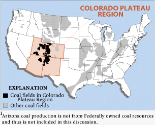 |
Park Service (NPS), or the Department of Agricultures
U.S. Forest Service (USFS). Additionally, coal is present beneath
many Tribal, State, and private lands in the Colorado Plateau Region.
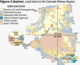
About 50 percent of the surface of the Colorado Plateau Region is administered by the BLM, USFS, NPS, or other Federal agencies. About 23 percent of the area consists of Tribal lands; although those lands are held in trust by the U.S. Government, they are not considered Federal lands and their coal resources are not included in this study. About 26 percent of the region is administered by State agencies or is privately owned. USGS Fact Sheet FS-145-99
|