 |
|
|
||||
| Fact Sheet 163–95 |
| About USGS / Science Topics / Maps, Products & Publications / Education / FAQ |
Abandoned and unrecorded wells may act as conduits for the contamination of groundwater supplies by oil field brines and other pollutants. The casings of abandoned wells eventually develop leaks, which, if not properly plugged, can allow pollutants to reach freshwater aquifers that supply drinking water. Sources of pollutants include brine ponds, landfill sites, agricultural activities, industrial activities, illegal disposal sites, or accidental spills. The problem is particularly acute in regions where there are old petroleum fields or where water wells have been extensively used for agricultural irrigation. Even urban areas can contain wells that were abandoned and concealed during development. Carefully designed ground magnetic or aeromagnetic surveys can be used to locate abandoned wells by mapping the magnetic disturbances or "anomalies" produced by their steel well casings. The U.S. Geological Survey (USGS) can, at the request of other Federal, State, or local agencies, conduct, process, and interpret such surveys, or it can aid in the design and monitoring of contracts for such surveys.
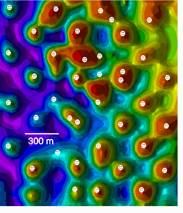
Figure - Color shaded-relief total field aeromagnetic map over part of the Coon Creek oil field near Arcadia, Oklahoma.
Red shades indicate high magnetic field values; blue shades indicate low magnetic field values. White symbols represent wells located on aerial photographs. The aeromagnetic data have been corrected for latitude-dependent effects under the assumption that all induced magnetization is parallel to the regional magnetic field. This correction brings most anomalies directly over their sources. There is good correspondence between the wells and the positive magnetic anomalies. Positive anomalies that do not correspond to identified wells may be due to tanks, metal buildings, or concealed wells. Wells that do not correspond to positive anomalies may be uncased.
The USGS has 50 years of experience in the development and application of aeromagnetic and ground magnetic survey methods. In particular, the USGS has taken the leading role in the study of abandoned well sites through the use of magnetic anomaly data. Examples include aeromagnetic surveys over four oil fields near Oklahoma City, Oklahoma, and one near Denver, Colorado (Frischknecht and Raab, 1984; Frischknecht and others, 1985; Frischknecht, 1990), and ground magnetic surveys over historical well sites in industrial and residential areas of the Santa Clara Valley, California (Jachens and others, 1986).
Isostatic residual gravity anomaly maps are produced by subtracting long-wavelength anomalies, produced by masses deep within the crust or mantle, from the Bouguer anomaly map. Isostatic residual gravity anomaly maps therefore reveal more clearly than Bouguer anomaly maps the density distributions within the upper crust that are of interest in many geologic and tectonic studies.
Locating abandoned wells is an important step toward reducing groundwater contamination. Once located, the wells can be sealed to prevent the transmission of contaminants into and between aquifers. Unfortunately, older well locations are frequently unrecorded or inaccurately recorded. Aeromagnetic and ground magnetic surveys provide an efficient direct method for locating these abandoned wells.
Jeffrey D. Phillips
U.S. Geological Survey
Box 25046, MS 964
Denver Federal Center
Denver, Colorado 80225
(303) 236-1206
Fax: (303) 236-1425
EMail: jeff@usgs.gov
| AccessibilityFOIAPrivacyPolicies and Notices | |
| |
|