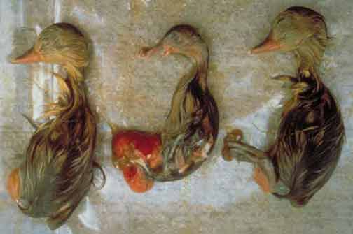
Selenium is an element required in trace amounts for human and animal health, but it can cause health problems for livestock, wildlife, and humans when ingested in higher-than-required concentrations. Incidences of mortality, birth defects, and reproductive failure in waterfowl were discovered at Kesterson National Wildlife Refuge, San Joaquin Valley, California, by the U.S. Fish and Wildlife Service (USFWS) in 1983 (Presser, 1994). These problems were attributed to elevated concentrations of selenium in irrigation drainage that discharged to the refuge. Because of concern about possible adverse effects from irrigation drainage on Department of the Interior (DOI) projects elsewhere in the United States, the DOI organized scientists from the U.S. Geological Survey (USGS), USFWS, Bureau of Reclamation (BOR), and Bureau of Indian Affairs (BIA) to form the National Irrigation Water-Quality Program (NIWQP). The objectives of the program are to investigate DOI-managed lands for potential contamination related to irrigation drainage, conduct studies to identify the problems, investigate methodologies to remediate those problems, and implement remediation plans (U.S. Department of the Interior, 2002).
Reconnaissance Studies directed by the NIWQP investigated 26 areas during 1986-95 (Engberg and others, 1998). Nine of these areas were further studied through NIWQP Detailed Studies. The completed Detailed Studies identified five areas with problems of sufficient magnitude to require further study or remediation:
| • Middle Green River basin of Utah, Colorado, and Wyoming (fig. 1), |
| • Kendrick Reclamation Project Area near Casper, Wyoming, |
| • Gunnison River/Grand Valley area of western Colorado, |
| • Stillwater National Wildlife Refuge near Carson City, Nevada, |
| • Salton Sea in southern California near the border with Mexico. |
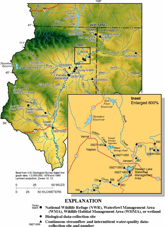
This fact sheet presents information about selenium in two areas of the middle Green River basin: Stewart Lake Waterfowl Management Area (WMA), located adjacent to the Green River near Jensen, Utah; and Ashley Creek, which flows near Vernal and Naples, Utah, and discharges to the Green River immediately south of Stewart Lake WMA (fig. 1). The purpose of this fact sheet is to summarize the scope of selenium contamination at each area and to discuss the progress toward reducing the concentration of selenium in water, bottom sediments, and biota at these important wetland and riparian habitats.
 Download the movie (QuickTime, 6.7 mb)
Selenium occurs naturally and is present in many sedimentary formations; however, it is often present in elevated amounts in marine formations of Tertiary and Cretaceous age and in soils derived from these formations (Seiler and others, 1999). Natural precipitation and irrigation water that infiltrates through these geologic formations and soils can oxidize selenium to soluble selenate (SeO42-) and, under proper hydrologic conditions, the mobilized selenium can be transported through irrigation drains and shallow ground-water movement and discharged to wildlife areas such as ponds, lakes, streams, and wetlands. In arid climates and terminal drainage basins, evaporation and transpiration can concentrate selenium in natural waters to toxic concentrations.
Studies indicate that adverse effects may occur in some fish and wildlife species when the concentration of total recoverable selenium in water is as small as 2 to 4 micrograms per liter (mg/L), which is equivalent to parts per billion, and when the concentration of selenium in sediment is greater than 4 micrograms per gram (mg/g) dry weight, which is equivalent to parts per million (U.S. Department of the Interior, 1998) (fig. 2). Reproductive impairment in some species of fish can occur when the concentration of selenium in whole-body fish tissue reaches 4 to 6 (mg/g) dry weight (U.S. Department of the Interior, 1998).
Stewart Lake WMA covers more than 500 acres and lies adjacent to the Green River (fig. 1), and is an important part of the migratory bird flyway. The State of Utah set the area aside in 1936 primarily for waterfowl habitat, and it is currently managed by the Utah Division of Wildlife Resources (DWR). At least 209 species of birds inhabit the area; nearly half are migrants. Several species of waterfowl use the area in large numbers including coot (Fulica atra), mallard (Anas platyrhynchos), and gadwall (Anas strepera). The endangered whooping crane (Grus americana) has been spotted in the area. Historically, Stewart Lake has served as a backwater area for two species of endangered fish that occur in the Green River, the Colorado pikeminnow (Ptychocheilus lucius) and the razorback sucker (Xyrauchen texanus) (Stephens and Waddell, 1998) (fig. 3).

Stewart Lake has a water-surface area of about 300 acres (fig 4). Ashley Creek and flood water from the Green River were the principal sources of water to the lake until 1981. Between 1981 and 1997, the primary sources of water to the lake were five subsurface irrigation drains from the agricultural area of Jensen, Utah. The drainage system services about 700 acres of irrigated farmland that is underlain by soils derived from the Cretaceous-age Mancos Shale, a geologic formation known to be seleniferous. Except for a short period of about one month each year and excluding water in shallow surface drains in the lake bed, Stewart Lake has been dry since 1997.

The Reconnaissance and Detailed Studies of the middle Green River basin showed that the median dissolved-selenium concentration in irrigation drainage discharging to Stewart Lake continually exceeded 5 µg/L and was as high as 140 µg/L (Stephens and others, 1988; Stephens and others, 1992). Measurements of dissolved selenium and discharge at the irrigation drains and the outflow from Stewart Lake showed that 75 percent of the selenium load from the drains was retained in Stewart Lake, presumably in the bottom sediment and biota (Stephens and others, 1992). Concentrations of total selenium in bottom-sediment samples collected in 1991 near the discharge points of the drains were as high 720 µg/g dry weight but declined to 4 to 7 µg/g near the outflow of Stewart Lake (Stephens and Waddell, 1998). Elevated concentrations of selenium were measured in biota at Stewart Lake, which resulted in decreased nesting success by water birds and low benthic insect populations (benthic insects are an important food source in aquatic environments) (Stephens and others, 1992).
Recent biological data collected by the USFWS between 1995 and 2000 showed that the median concentration of selenium in whole-body carp samples collected from Stewart Lake was 19.8 µg/g dry weight, and the median concentration in carp from nearby sites on the Green River was 6.4 µg/g dry weight (fig. 5, top) (Rowland and others, 2002). The concentration of selenium in muscle plugs collected from four razorback suckers that were captured and released by the USFWS at Stewart Lake in June 1997 ranged from 12.1 to 21.5 µg/g dry weight (Rowland and others, 2002).

As a result of the elevated concentrations of selenium measured in biota from Stewart Lake WMA, the State of Utah Health Department issued a health advisory on September 26, 1988, limiting human consumption of fish and waterfowl from the area. The elevated concentrations of selenium measured in water, bottom-sediment, and biota, including endangered fish, at Stewart Lake prompted the NIWQP to initiate planning for remediation in 1997. The NIWQP assumed responsibility for remediation of Stewart Lake because the source of selenium was related to irrigation drainage from a DOI irrigation project.
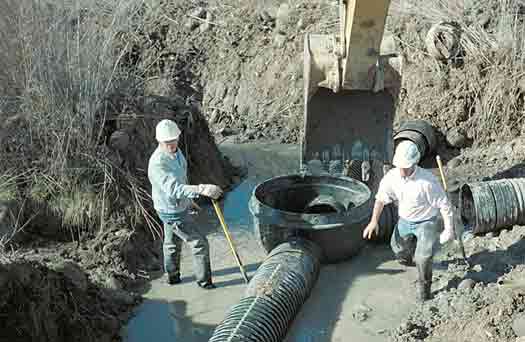
Under the direction of the NIWQP, and with the cooperation of all concerned parties, including the agricultural community, an environmental assessment was completed for the Stewart Lake area in September 1997 (Bureau of Reclamation, 1997). Following an initial evaluation of more than 80 possible alternatives, eight were considered in detail. A two-phased approach was selected to restore the biological productivity of Stewart Lake WMA and to eliminate selenium hazards to waterfowl and endangered fish that use the area. Phase 1 activities were completed between 1997 and 1998. In May 1997, an inlet channel linking the eastern part of Stewart Lake to the Green River was constructed (fig. 4). This was done to capture high flows that periodically occur on the Green River. To discourage waterfowl and fish from using Stewart Lake during remediation activities and to dry the bottom sediment, drainage channels were cut in the lake in October 1997. In November 1997 and June 1998, the subsurface irrigation drains that were the principal source of selenium to Stewart Lake were extended to the Green River where the selenium they carry is diluted to less than 1 µg/L (Stephens and Waddell, 1998) (fig. 6, top). Phase 2 activities began in 1999 and included the installation of flow-control structures at the inlet and outlet of Stewart Lake. These structures are used to facilitate seasonal flooding of the lake with water from the Green River and will aid its future management (fig. 6, bottom). In addition, good-quality water (selenium concentration less than 2 µg/L) from Brush Creek was secured as a permanent water supply for the lake, and a pipeline to deliver the water was completed in 2001. One of the remaining tasks is to reduce the concentration of selenium in the bottom sediment at Stewart Lake.

To reduce the concentration of selenium in the sediment, Stewart Lake has been flooded with water from the Green River and immediately drained on an annual basis since 1997. The theory behind the flood and drain cycle is that elemental selenium and adsorbed selenium, in the form of selenite, are oxidized when the lake is drained. The oxidized selenium, in the form of selenate, is then dissolved in floodwater from the Green River and discharged to the Green River when the lake is drained. The annual flood cycle also should enhance the conversion of elemental selenium to methylated forms, which are gaseous and may be released to the atmosphere. The conversion of elemental selenium to methylated forms is a process mediated by certain types of plants, fungi, and bacteria (Frankenberger and Karlson, 1995). The goal is to reduce the concentration of selenium in the upper layer of bottom sediment to 4 µg/g or less.
Ashley Creek drains Ashley Valley, near Vernal, Utah, and discharges to the Green River just south of Stewart Lake WMA (fig. 1). Discharge in Ashley Creek varies seasonally and at site 09271550, near Stewart Lake, can range from 0.03 cubic foot per second (ft3/s) in late summer to 4,300 ft3/s during spring run off (Herbert and others, 2002, p. 84). During 1992-2001, annual mean discharge in Ashley Creek at this site was 67.5 ft3/s (Herbert and others, 2002, p. 84). Wetlands adjacent to Ashley Creek near U.S. Highway 40 provide considerable wildlife habitat, and the endangered razorback sucker and Colorado pikeminnow are known to inhabit the Green River near the mouth of Ashley Creek (Stephens and others, 1992). In 1981, a sewage-lagoon system (Vernal sewage lagoons, fig. 1) was constructed on the hills east of Ashley Creek, which consist of Mancos Shale. This system of lagoons did not directly discharge treated wastewater to Ashley Creek; however, later study linked the Vernal sewage lagoons to elevated concentrations of selenium in Ashley Creek.
Selenium contamination in Ashley Creek was first documented during the Reconnaissance Study of the middle Green River basin (Stephens and others, 1988), which reports that the concentration of selenium in water from the lower reach of the creek ranged from 25 to 75 µg/L and that the creek discharged 8 kilograms (kg) of selenium per day to the Green River. Synoptic sampling along Ashley Creek indicated that the area contributing the most selenium to the creek was immediately downgradient of the Vernal sewage lagoons (fig. 1). Stephens and Waddell (1998) hypothesized that selenium-free water in the lagoons leaked from the facility, infiltrated through fractured Mancos Shale (mobilizing high concentrations of selenium), and discharged to Ashley Creek in seeps and shallow ground water. Stephens and Waddell (1998) estimated that 85 percent of the selenium load in Ashley Creek was a result of leakage from the lagoons.
Biota collected from Ashley Creek during the Reconnaissance and Detailed Studies had selenium concentrations that ranked among the highest measured in the middle Green River basin. The concentration of selenium in whole-body fish samples from four sites on Ashley Creek downgradient of the Vernal sewage lagoons ranged from 1.6 to 122 µg/g dry weight with a geometric mean of 32.7 µg/g (Stephens and Waddell, 1998). The large selenium load in Ashley Creek may account in part for the relatively high concentrations of selenium in carp collected from the Green River near the mouth of Ashley Creek. Data collected by the USFWS during 1995-2000 showed that the median dry weight concentration of selenium in whole-body tissue samples of carp was 14.9 µg/g near the mouth of Ashley Creek (at site SA), 7.9 µg/g at site EB (upstream from site SA), and 3.4 µg/g at site SB (downstream from site SA) (Rowland and others, 2002) (fig. 5, bottom).
The toxic concentrations of selenium measured in water and biota from Ashley Creek prompted the USFWS to urge the Ashley Valley Water and Sewer District, the Utah Department of Environmental Quality, and the U.S. Environmental Protection Agency to take action to prevent seepage from the lagoons from contaminating Ashley Creek (Stephens and Waddell, 1998). The NIWQP was not asked to participate in the remediation of Ashley Creek because the source of selenium was not related to a DOI irrigation project; however, NIWQP scientists identified the selenium problem in Ashley Creek and helped to determine that the source of selenium in the creek was leakage from the Vernal sewage lagoons.
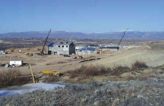
In May 1999, construction began on a wastewater-treatment facility adjacent to the Vernal sewage lagoons (fig. 7). The facility was operational in April 2001 and the sewage lagoons were decommissioned at that time. The new wastewater-treatment facility utilizes a sealed oxidation ditch containing activated sludge to break down organic matter. Wastewater is then passed through secondary clarifiers and an ultraviolet disinfection system before it is discharged to Ashley Creek. Wastewater and treated wastewater do not come in contact with the Mancos Shale, eliminating the potential for selenium contamination. The concentration of selenium in the effluent from the wastewater-treatment facility is monitored monthly. In 2001, the maximum concentration of selenium in the effluent was 2.8 µg/L and averaged 1.7 µg/L (Pryor Harrell, Ashley Valley Sewer Management Board, written commun., 2002).
The BOR collects bottom-sediment samples from numerous sites at Stewart Lake to evaluate the effectiveness of the flood and drain remediation cycle for removing selenium (fig. 4). As many as 10 samples from the top 6 inches of sediment at each site are composited and analyzed for total selenium before and after each flood (Rowland and others, 2002). Post-flood bottom-sediment data for 1995 to 2001 show that the flood and drain cycle, which began in 1997, has not been effective for decreasing the concentration of selenium to the remediation goal of 4 µg/g or less (fig. 8). The data also show that samples from sites near uncontrolled seepage in the north Stewart Lake area contain a higher concentration of selenium relative to samples from sites located in non-seepage areas (fig. 4). The BOR is experimenting with soil amendments to enhance selenium removal during the flood and drain cycles and is planning a new drain to capture the seepage in the north Stewart Lake area.
To evaluate changes in water quality in Ashley Creek that may result from operation of the new wastewater-treatment facility and abandonment of the Vernal sewage lagoons, the USGS, in cooperation with the BOR, Colorado River Basin Salinity Control Program, installed continuous-monitoring stations upstream (site 09271400) and downstream (site 09271450) of the Vernal sewage lagoons in November 1999 (fig. 1). The stations monitor stage, specific conductance, and temperature. Water samples are collected at the monitoring stations nine times each year and analyzed for selenium and dissolved-solids concentration. In addition, several seeps and monitoring wells near the Vernal sewage lagoons are monitored. Preliminary analysis of data collected up to May 2002 show that discharge from seeps near the sewage lagoons declined after the sewage lagoons were decommissioned and the selenium load discharged to the Green River via Ashley Creek declined by about 6 percent during the same period (Dave Naftz, U.S. Geological Survey, written commun., 2003). Monitoring will continue through September 2003.

The remediation goal of the NIWQP at Stewart Lake WMA is to reduce or eliminate the impacts of selenium to biota, which will help restore the lake and wetlands as part of the migratory bird corridor and restore critical habitat to fish species endemic to the Green River drainage. The goal of the State and Federal effort to remediate Ashley Creek is to reduce the salt load (including selenium) it delivers to the Green River. This will improve conditions in the Green River at the mouth of Ashley Creek and improve the riparian ecosystem on lower Ashley Creek. At Stewart Lake, efforts to reduce the concentration of selenium in sediment will continue with soil ammendment experiments, and the last major source of selenium will be diverted from the lake by a new irrigation drain. At Ashley Creek, ongoing monitoring will determine if the selenium load it carries will continue to decline as seepage from the decommissioned sewage lagoons decreases.
Bureau of Reclamation, 1997, Middle Green River Basin study-Stewart Lake Waterfowl Management Area: Final Environmental Assessment PRO-EA-97-001, Provo, Utah, 113 p. and 5 attachments.
Engberg, R.A., Westcot, D.W., Delamore, M., and Holtz, D.D., 1998, Federal and state perspectives on regulation and remediation of irrigation-induced selenium problems, in Frankenberger, W.T., Jr., and Engberg, R.A., eds., Environmental Chemistry of Selenium: New York, Marcel Dekker, Inc., p. 1-25.
Frankenberger, W.T., and Karlson, U., 1995, Volatilization of selenium from a dewatered seleniferous sediment: A field study: Journal of Industrial Microbiology, v. 14, p. 226-232.
Herbert, L.R., Wilberg, J.R., and Tibbetts, J.R., 2002, Water resources data, Utah, water year 2001: U.S. Geological Survey Water-Data Report UT-01-1.
Presser, T.S., 1994, The Kesterson effect: Environmental Management, v. 18, no. 13, p.437454.
Rowland, R.C., Allen, D.V., Stephens, D.W., Yahnke, J.W., Darnall, N.L., and Waddell, Bruce, 2002, Hydrologic, sediment, and biological data associated with irrigation drainage in the middle Green River basin, Utah and Colorado, water years 1991-2000: U.S. Geological Survey Open File Report 02-343, 112 p.
Seiler, R.L., Skorupa, J.P., and Peltz, L.A., 1999, Areas susceptible to irrigation-induced selenium contamination of water and biota in the western United States: U.S. Geological Survey Circular 1180, 36 p.
Stephens, D.W., and Waddell, Bruce, 1998, Selenium sources and effects on biota in the Green River basin of Wyoming, Colorado, and Utah, in Frankenberger, W.T., Jr., and Engberg, R.A., eds., Environmental Chemistry of Selenium: New York, Marcel Dekker, Inc., p. 183-203.
Stephens, D.W., Waddell, Bruce, and Miller, J.B., 1988, Reconnaissance investigation of water quality, bottom sediment, and biota associated with irrigation drainage in the middle Green River basin, Utah, 1986-87: U.S. Geological Survey Water-Resources Investigations Report 88-4011, 70 p.
Stephens, D.W., Waddell, Bruce, Peltz, L.A., and Miller, J.B., 1992, Detailed study of selenium and selected elements in water, bottom sediment, and biota associated with irrigation drainage in the middle Green River basin, Utah, 1988-90: U.S. Geological Survey Water-Resources Investigations Report 92-4084, 164 p.
U.S. Department of the Interior, 1998, National Irrigation Water-Quality Program Information Report No. 3: Guidelines for Interpretation of the Biological Effects of Selected Constituents in Biota, Water, and Sediment, accessed June 25, 2002, at URL http://www.usbr.gov/niwqp/guidelines/
______ 2002, National Irrigation Water-Quality Program: Program Description, accessed June 25, 2002, at URL http://www.usbr.gov/niwqp/info/phases/
Information on technical reports and hydrologic data related to the National Irrigation Water-Quality Program can be obtained from:
NIWQP internet home page— http://www.usbr.gov/niwqp/
Or by writing to:
John Harb, Manager
National Irrigation Water-Quality Program
Bureau of Reclamation
P.O. Box 25007 (D-5010)
Denver Federal Center
Denver, CO 80225
1 U.S. Geological Survey
2329 Orton Circle
Salt Lake City, UT 84119-2047
2 U.S. Fish and Wildlife Service
2369 Orton Circle Suite 50
Salt Lake City, UT 84119
Document Accessibility: Adobe Systems Incorporated has information about PDFs and the visually impaired. This information provides tools to help make PDF files accessible. These tools convert Adobe PDF documents into HTML or ASCII text, which then can be read by a number of common screen-reading programs that synthesize text as audible speech. In addition, an accessible version of Acrobat Reader 5.0 for Windows (English only), which contains support for screen readers, is available. These tools and the accessible reader may be obtained free from Adobe at Adobe Access.
Send questions or comments about this report to the author, David L. Naftz (dlnaftz@usgs.gov) 801.908.5000.
For more information about USGS activities in Utah, visit the USGS Utah District home page.
| AccessibilityFOIAPrivacyPolicies and Notices | |
 |
|